
Milwaukee County ( ) is a county located in the U.S. state of Wisconsin. At the 2020 census, the population was 939,489, down from 947,735 in 2010. It is both the most populous and most densely populated county in Wisconsin, and the 45th most populous county nationwide; Milwaukee, its eponymous county seat, is also the most populous city in the state. It was named after the Milwaukee River. The county was created in 1834 as part of Michigan Territory and organized the following year.

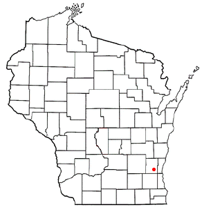
Cudahy is a city in Milwaukee County, Wisconsin, United States. The population was 18,204 at the 2020 census. A suburb south of Milwaukee along the shore of Lake Michigan, it is part of the Milwaukee metropolitan area.

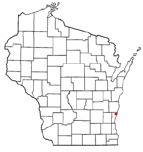
Oak Creek is a city in Milwaukee County, Wisconsin, United States. It sits on the southwestern shore of Lake Michigan and is located immediately south of Milwaukee. The population was 36,497 at the 2020 census. The city is one of the fastest growing in Milwaukee County and all of Wisconsin. The area has experienced an economic boom in recent years, with the addition of large companies such as Amazon, IKEA, and the Astronautics Corporation of America.

Whitefish Bay is a village in Milwaukee County, Wisconsin, United States. The population was 14,954 at the 2020 census. A suburb north of Milwaukee along the shore of Lake Michigan, it is part of the Milwaukee metropolitan area.

Caledonia is a village in Racine County, Wisconsin, United States. The population was 25,361 at the 2020 census. The residential community of Franksville is located within the village. Franksville is a former census-designated place. The residential neighborhood of Husher is also located within the village. The lakeside community of Tabor is also in the village.

Sturtevant is a village in Racine County, Wisconsin, United States. The population was 6,919 at the 2020 census.

Bayside is a village in Milwaukee and Ozaukee counties in the U.S. state of Wisconsin. The population was 4,482 at the 2020 census. Of this, 4,378 were in Milwaukee County, and only 104 were in Ozaukee County.

Granville is a town on the eastern border of Washington County, New York, United States, abutting Rutland County, Vermont. It is part of the Glens Falls Metropolitan Statistical Area. The town population was 6,215 at the 2020 census.
Belgium is a town in Ozaukee County, Wisconsin, United States. The population was 1,513 at the 2000 census. The Village of Belgium is surrounded on all sides by the town, and the unincorporated communities of Decker, Holy Cross, Lake Church, and Sauk Trail Beach are located in the town, as is the ghost town of Stonehaven. The unincorporated community of Dacada is also partially located in the town.

Belgium is a village in Ozaukee County, Wisconsin, United States. Located along Interstate 43, the village is one of the northernmost communities in the Milwaukee metropolitan area. The population was 2,245 at the 2020 census.

Fredonia is a village in Ozaukee County, Wisconsin, United States. Located on the Milwaukee River, the village is in the Milwaukee metropolitan area. The population was 2,160 at the 2010 census.

Fredonia is a town in Ozaukee County, Wisconsin, United States. The population was 2,903 at the 2000 census. The Village of Fredonia is surrounded by the town. The unincorporated communities of Little Kohler and Waubeka are also located in the town.

The Town of Grafton is a town located in Ozaukee County, Wisconsin, United States, and is in the Milwaukee metropolitan area. The town was created in 1846 and at the time of the 2020 Census had a population of 4,157.

Grafton is a village in Ozaukee County, Wisconsin, United States. Located about 20 miles (32 km) north of Milwaukee and in close proximity to Interstate 43, it is a suburban community in the Milwaukee metropolitan area. The village incorporated in 1896, and at the time of the 2020 census the population was 12,094.

Port Washington is a town in Ozaukee County in the U.S. state of Wisconsin. It surrounds the northern and western side of the city of Port Washington. As of the 2020 census, the town population was 1,538. The unincorporated communities of Druecker and Knellsville are also located in the town.
Germantown is a town in Washington County, Wisconsin, United States. The population was 278 at the 2000 census. It is surrounded by the village of Germantown.

Germantown is a village in Washington County, Wisconsin, United States. The population was 20,917 at the 2020 census. The village surrounds the Town of Germantown. In July 2007, Germantown was ranked the 30th most appealing place to live in the United States by Money Magazine.

Jackson is a town in Washington County, Wisconsin, United States. The population was 3,516 at the 2000 census. The Village of Jackson is located partially within the town. The unincorporated community of Kirchhayn is also located in the town.

Pewaukee is a city in Waukesha County, Wisconsin, United States. The population was 15,914 at the 2020 census. It is part of the Milwaukee metropolitan area.

Granville was a town located in Milwaukee County, Wisconsin, United States. One portion was incorporated as the village of Brown Deer in 1955; the remainder consolidated with the City of Milwaukee in 1956, and became a neighborhood of Milwaukee.


