Pewaukee (village), Wisconsin

Last updated

Pewaukee, Wisconsin
Forest Grove Drive, Village of Pewaukee (October 2023) 02.jpg
Waukesha County Wisconsin Incorporated and Unincorporated areas Pewaukee Highlighted 5562250.svg
Location of Pewaukee in Waukesha County, Wisconsin.
Coordinates: 43°4′58″N88°15′10″W / 43.08278°N 88.25278°W / 43.08278; -88.25278
Country Flag of the United States.svg  United States
State Flag of Wisconsin.svg  Wisconsin
County Waukesha
Area
[1]
  Total4.58 sq mi (11.85 km2)
  Land4.16 sq mi (10.77 km2)
  Water0.42 sq mi (1.08 km2)
Elevation
[2]
873 ft (266 m)
Population
 (2020) [3]
  Total8,238
  Density1,950.71/sq mi (753.21/km2)
Time zone UTC-6 (Central (CST))
  Summer (DST) UTC-5 (CDT)
Area code 262
FIPS code 55-62250 [4]
GNIS feature ID1583915 [2]
Website www.villageofpewaukee.com

Pewaukee is a village in Waukesha County, Wisconsin, United States. The population was 8,238 at the 2020 census. The village is nearly surrounded by the City of Pewaukee. The village was incorporated from what was formerly the Town of Pewaukee, and the remainder of the town later incorporated as a city.

Contents

History

The present-day village of Pewaukee was settled in about 1837 by the Deacon Asa Clark of Lunenburg, Vermont, when he erected a hotel, sawmill, and church in this location. Pewaukee became a town in the year 1840, and then a village later in 1876. [5] [6]

Pewaukee is constructed upon aki or (w)aukee, which means "land" or "location" in several Algonquian languages. The significance and outright etymology of the initial syllable of the name is uncertain. Sources in Ojibwe nibiwaki "watery (i.e., swampy) place", Potawatomi pee-wauk-ee-wee-nick "the dusty water" or "lake of shells", and Menominee pee-wau-nau-kee "place of flint" have been suggested, as well as rather less unclear attributed meanings such as "snail lake," "flinty place," and "clean land". [5] [7] [8] [9] [10]

Geography

Pewaukee is located at 43°4′57″N88°15′10″W / 43.08250°N 88.25278°W / 43.08250; -88.25278 (43.082659, -88.252842). [11]

According to the United States Census Bureau, the village has a total area of 4.53 square miles (11.73 km2), of which, 4.13 square miles (10.70 km2) of it is land and 0.40 square miles (1.04 km2) is water. [12]

Demographics

Historical population
CensusPop.Note
1960 2,484
1970 3,27131.7%
1980 4,63741.8%
1990 5,28714.0%
2000 8,17054.5%
2010 8,1660.0%
2020 8,2380.9%

2010 census

As of the census [3] of 2010, there were 8,166 people, 3,903 households, and 2,043 families living in the village. The population density was 1,977.2 inhabitants per square mile (763.4/km2). There were 4,160 housing units at an average density of 1,007.3 per square mile (388.9/km2). The racial makeup of the village was 92.4% White, 1.1% African American, 0.2% Native American, 3.9% Asian, 0.1% Pacific Islander, 1.1% from other races, and 1.2% from two or more races. Hispanic or Latino of any race were 3.5% of the population.

There were 3,903 households, of which 24.9% had children under the age of 18 living with them, 40.0% were married couples living together, 8.8% had a female householder with no husband present, 3.5% had a male householder with no wife present, and 47.7% were non-families. 41.3% of all households were made up of individuals, and 15.8% had someone living alone who was 65 years of age or older. The average household size was 2.08 and the average family size was 2.87.

The median age in the village was 41.4 years. 20.8% of residents were under the age of 18; 6.5% were between the ages of 18 and 24; 27.8% were from 25 to 44; 28.5% were from 45 to 64; and 16.4% were 65 years of age or older. The gender makeup of the village was 47.1% male and 52.9% female.

2000 census

As of the census [4] of 2000, there were 8,170 people, 3,635 households, and 2,079 families living in the village. The population density was 1,986.2 people per square mile (767.5/km2). There were 3,761 housing units at an average density of 914.3/sq mi (353.3/km2). The racial makeup of the village was 96.19% White, 0.58% Black or African American, 0.22% Native American, 1.80% Asian, 0.35% from other races, and 0.86% from two or more races. 1.21% of the population were Hispanic or Latino of any race.

There were 3,635 households, out of which 28.3% had children under the age of 18 living with them, 46.7% were married couples living together, 7.7% had a female householder with no husband present, and 42.8% were non-families. 35.5% of all households were made up of individuals, and 7.6% had someone living alone who was 65 years of age or older. The average household size was 2.19 and the average family size was 2.89.

In the village, the population was spread out, with 22.2% under the age of 18, 7.1% from 18 to 24, 37.3% from 25 to 44, 21.3% from 45 to 64, and 12.1% who were 65 years of age or older. The median age was 36 years. For every 100 females, there were 90.4 males. For every 100 females age 18 and over, there were 86.6 males.

The median income for a household in the village was $53,874, and the median income for a family was $66,940. Males had a median income of $43,284 versus $31,477 for females. The per capita income for the village was $26,656. About 1.2% of families and 2.3% of the population were below the poverty line, including 2.5% of those under age 18 and 3.0% of those age 65 or over.

Business

The village of Pewaukee is home to one of the three locations of Dynex/Rivett Inc., a manufacturer of hydraulic components and systems. It was also home to Necco Stark, formerly Stark Candy Co. The Pewaukee candy location closed on May 30, 2008. Pewaukee is also the home of Logic Design Corporation, the developers of Global Edge Engineering and Manufacturing Software. Another business located in Pewaukee is PM Plastics, a custom injection molding company.

The village is home to the Old Main Street building on Wisconsin Avenue. Opened in 2002 across from the beach on Pewaukee Lake, Old Main Street replicates the charm of a late 1800s building with modern up to date facilities. It is the home of small businesses that include restaurants (Seesters and The Chocolate Factory), a salon, a bakery, a pilates/yoga/barre studio, a bead shop, a home builder, a construction management firm, a recruitment firm (Joel Frank & Associates), and a software company (Logic Design Corporation).

Education

Pewaukee School District serves both the village and the city of Pewaukee, Wisconsin. The district includes four separate buildings all contained in a single-campus environment. The school buildings serve early childhood through 2nd grades, 3rd through 5th, 6th through 8th, and 9th through 12th grades.

WCTC's main campus is located in the village of Pewaukee, Wisconsin. The technical college is part of the 16 technical colleges that make up the Wisconsin Technical College System (WTCS). WCTC has a small but modern campus in Pewaukee within the heart of the lake country area. While Pewaukee is the main campus for WCTC, it also has a satellite campus in Waukesha.

See also

Related Research Articles

<span class="mw-page-title-main">Menominee, Illinois</span> Village in Illinois, United States

Menominee is a village in Jo Daviess County, Illinois, United States. The population was 248 at the 2010 census, up from 237 in 2000. The village is located on the Little Menominee River near East Dubuque and Galena.

<span class="mw-page-title-main">Ashwaubenon, Wisconsin</span> Village in Wisconsin, United States

Ashwaubenon is a village in Brown County in the U.S. state of Wisconsin. The population was 16,991 at the 2020 census. A suburb of Green Bay, Ashwaubenon is part of the Green Bay Metropolitan Statistical Area and carries a Green Bay mailing address. Part of the Oneida Nation of Wisconsin is in Ashwaubenon.

<span class="mw-page-title-main">Nasewaupee, Wisconsin</span> Town in Wisconsin, United States

Nasewaupee is a town in Door County, Wisconsin, United States. The population was 2,061 at the 2010 census. The unincorporated community of Idlewild is located in the town, as is Sherwood Point Light and Potawatomi State Park.

<span class="mw-page-title-main">Meeme, Wisconsin</span> Town in Wisconsin, United States

Meeme is a town in Manitowoc County, Wisconsin, United States. The population was 1,538 at the 2000 census. Its Menominee name is Omīnīw which means "pigeon". The Menominee sold this land to the United States in the 1831 Treaty of Washington.

<span class="mw-page-title-main">Keshena, Wisconsin</span> CDP in Wisconsin, United States

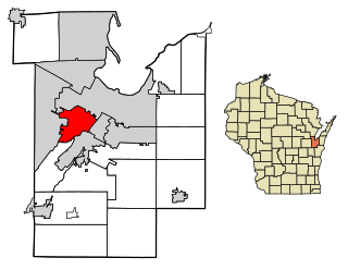
Keshena is a census-designated place (CDP) in and the county seat of Menominee County, Wisconsin, United States. Located on the Menominee Indian Reservation, it had a population of 1,257 at the 2020 census. Keshena was named for an Indian chief; the Menominee name is Kesīqnaeh which means "Swift Flying".

<span class="mw-page-title-main">Neopit, Wisconsin</span> CDP in Wisconsin, United States

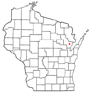
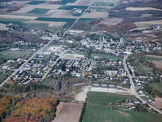
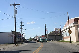
Neopit is a census-designated place (CDP) in Menominee County, Wisconsin, United States. The population was 616 at the 2020 census. Neopit is located along Wisconsin Highway 47 at its intersection with County Road M, approximately 3 miles (4.8 km) southeast of Zoar. The name derives from the Menominee name Neyōpet which means "four sitting".

<span class="mw-page-title-main">Zoar, Wisconsin</span> CDP in Wisconsin, United States

Zoar is a census-designated place (CDP) and unincorporated community in Menominee County, Wisconsin, United States. The population was 107 at the 2020 census. Zoar is located along Wisconsin Highway 47, approximately 3 miles (4.8 km) northwest of Neopit. Situated within traditional Menominee territory, it is known in the Menominee language as Saqnawehnaen, a name which refers to a fork in a stream.

<span class="mw-page-title-main">River Hills, Wisconsin</span> Village in Milwaukee County, Wisconsin

River Hills is a village in Milwaukee County, Wisconsin, United States. The population was 1,602 at the 2020 census.

<span class="mw-page-title-main">Stiles, Wisconsin</span> Town in Wisconsin, United States

Stiles is a town in Oconto County, Wisconsin, United States. The population was 1,465 at the 2000 census. The unincorporated communities of Stiles and Stiles Junction are located in the town. Situated within ancestral Menominee territory that was ceded to the United States in the 1836 Treaty of the Cedars, its Menominee name is Pæhkuahkiw which means "pointed hillock".

<span class="mw-page-title-main">Shiocton, Wisconsin</span> Village in Wisconsin, United States

Shiocton is a village in Outagamie County, Wisconsin, United States. The population was 921 at the 2010 census. It is wholly surrounded by the Town of Bovina.

<span class="mw-page-title-main">Bonduel, Wisconsin</span> Village in Wisconsin, United States

Bonduel is a village in Shawano County, Wisconsin, United States. The population was 1,478 at the 2010 census.

<span class="mw-page-title-main">Waukechon, Wisconsin</span> Town in Wisconsin, United States

Waukechon is a town in Shawano County, Wisconsin, United States. The population was 928 at the 2000 census. The unincorporated community of Lunds is located in the town. Its Menominee name is Wākecānāpāēw, meaning "crooked beak man", a reference to the Thunderbird Clan of the Ho-Chunk.

<span class="mw-page-title-main">Clintonville, Wisconsin</span> City in Wisconsin, United States

Clintonville is a city in Waupaca County, Wisconsin, United States. The population was 4,591 at the 2020 census. The area that became Clintonville was first settled in March, 1855.

<span class="mw-page-title-main">Middle Village, Wisconsin</span> CDP in Wisconsin, United States

Middle Village is a census-designated place (CDP), in the towns of Menominee and Red Springs, in Menominee and Shawano counties in the U.S. state of Wisconsin. It does not have any legal status as an incorporated municipality. The population was 290 at the 2020 census.

Edwards is a hamlet in St. Lawrence County, New York, United States. The population was 439 at the 2010 census. It was an incorporated village until dissolution in 2012.

<span class="mw-page-title-main">Mishicot, Wisconsin</span> Village in Wisconsin, United States

Mishicot is a village in Manitowoc County, Wisconsin, United States. The population was 1,442 at the 2010 census. The village is adjacent to the Town of Mishicot.

<span class="mw-page-title-main">Wausaukee, Wisconsin</span> Village in Wisconsin, United States

Wausaukee is a village in Marinette County, Wisconsin, in the United States. The population was 596 at the 2020 census. The village is part of the Marinette, WI–MI Micropolitan Statistical Area.

<span class="mw-page-title-main">Pewaukee, Wisconsin</span> City in Wisconsin, United States

Pewaukee is a city in Waukesha County, Wisconsin. The population was 15,914 at the 2020 census. The Village of Pewaukee, which was incorporated out of the town before it incorporated as a city, is surrounded by the city.

Winneconne is a town in Winnebago County, Wisconsin, United States. The population was 2,350 at the 2010 census. The Village of Winneconne is located within the town, on both sides of the Wolf River. The unincorporated community of Butte des Morts, named for a French and Native American trading war, is also located in the town. The town's water resources of rivers and lakes makes it a center of hunting and fishing, including winter ice fishing.

<span class="mw-page-title-main">Winneconne, Wisconsin</span> Village in Wisconsin, United States

Winneconne is a village in Winnebago County, Wisconsin. The population was 2,383 at the time of the 2010 census. The village is located within the Town of Winneconne. Developed along the Wolf River, the city is in the middle of the Wolf Chain of lakes, including Poygan, Winneconne, and Butte des Morts. It is host to numerous bass fishing tournaments.

References

  1. "2019 U.S. Gazetteer Files". United States Census Bureau. Retrieved August 7, 2020.
  2. 1 2 "US Board on Geographic Names". United States Geological Survey. October 25, 2007. Retrieved January 31, 2008.
  3. 1 2 "U.S. Census website". United States Census Bureau . Retrieved November 18, 2012.
  4. 1 2 "U.S. Census website". United States Census Bureau . Retrieved January 31, 2008.
  5. 1 2 Callary, Edward (2016). Place Names of Wisconsin. Madison, Wisconsin: University of Wisconsin Press. ISBN   9780299309640.
  6. "Pewaukee Area Historical Society - Online". Pewaukee Area Historical Society. Retrieved January 14, 2019.
  7. Virgil J., Vogel (1991). Indian Names on Wisconsin's Map. University of Wisconsin Press.
  8. "Approach of the White Man." History of Milwaukee. Chicago: The Western Historical Company, 1881. pp. 33-55.
  9. Dictionary of Wisconsin History
  10. Hoffman, Mike. Menominee Place Names in Wisconsin. The Menominee Clans Story.
  11. "US Gazetteer files: 2010, 2000, and 1990". United States Census Bureau. February 12, 2011. Retrieved April 23, 2011.
  12. "US Gazetteer files 2010". United States Census Bureau. Archived from the original on January 25, 2012. Retrieved November 18, 2012.