Menominee and SaukNative Americans lived in the area until the 1830s when the U.S. Federal Government forced them to leave Wisconsin. The first white settlers in the mid-1840s, and the Town of Saukville was organized in 1848. The early settlers were farmers, and dairy farming became the primary economic activity by the early 1900s. The Village of Saukville incorporated from some of the town's land in 1915, and while the village has become increasingly industrial, agriculture still plays a major role in the Town of Saukville's economy.
The town has thousands of acres of undeveloped, biodiverse bogs, coniferous swamps, and primeval beech-maple forests. The largest of the community's natural areas is the 2,200-acre Cedarburg Bog State Natural Area. The town's bogs are a habitat for many endangered species, birds, and carnivorous plants. Among other landforms, the Cedarburg Bog contains a string bog—a geographic feature that seldom occurs as far south as Wisconsin—which contains many plant species rarely seen outside remote parts of Canada.
History
Saukville was the site of a Native American village at the crossroads of two trails, one of which became the north-south Green Bay Road and the other the east-west Dekora Road.[3] Also located on the banks of the Milwaukee River, the village's inhabitants were probably Menominee and Sauk people.[4] The Native Americans were forced to leave Wisconsin in the 1830s, and white settlers arrived in the area around 1845 and began to build along Green Bay Road.
Saukville was part of the town of Port Washington until 1848 when the Town of Saukville was established. Throughout the 19th and early 20th centuries, Saukville was a rural community with many dairy farmers.[5] In 1871, a rail line was constructed through Saukville. It would eventually become part of the Chicago, Milwaukee & St. Paul Railway.
The Village of Saukville incorporated out of some of the Town of Saukville's land in 1915.[6] In 1973, the Village of Newburg incorporated from some of the Town of Saukville's land as well as land from the neighboring Town of Trenton in Washington County.[7]
Geography
The Cedarburg Beech Woods State Natural Area west of the village contains an old-growth beech-maple forest, much like the ones that blanketed Saukville before settlers arrived in the 1800s.The Cedarburg Bog State Natural Area contains many biodiverse wetlands with plant species seen in few other ecosystems.
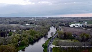
The town is located in the Southeastern Wisconsin glacial till plains that were created by the Wisconsin glaciation during the most recent ice age. The town has many glacial landforms, including kames, kettles, and moraines. Much of the community is located on the Racine Dolomite formation that stretches through eastern Wisconsin and Illinois. The formation contains Silurian marine fossils, and while much of the rock lies between 25 and 50 feet below the surface, the fossils of a prehistoric reef can be seen in some old quarries in the northern part of the Village of Saukville as well as in the 50-foot-high bluff along the Milwaukee River at Riveredge Nature Center.[8]
Before white settlers arrived in the area, the Saukville area was an upland forest dominated by American beech and sugar maple trees. There were also white cedars growing along the Milwaukee River and several thousand acres of coniferous swamp in Saukville's southwest quadrant. Much of the original forest—with the exception of the coniferous swamps—was cleared to prepare the land for agriculture. The Cedarburg Beech Woods State Natural Area in the western part of the town has old growth endemic trees with minimal damage from logging and retains the character of the pre-settlement beech-maple forests.[8]
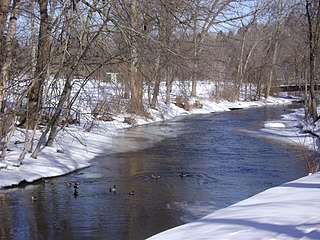
A network of streams, ponds and lakes flow through the Cedarburg Bog. Many of the Saukville area's bogs and swamps are flooded glacial kettles formed during the most recent ice age.
The town has many nature preserves and other undisturbed natural areas, the largest of which is the Cedarburg Bog State Natural Area, a 2,200-acre National Natural Landmark with high biodiversity, which is home to many endangered plant and animal species. The largest and best preserved bog in eastern Wisconsin, it contains two lakes, extensive white cedar and tamarack coniferous swamps, and the southernmost string bog on Earth.[8] The bog is a habitat for several carnivorous plant species, including bladderworts, pitcher plants, and round-leafed sundews.[9][10] The U.S. Fish and Wildlife Service also considers the Cedarburg Bog to be an important habitat for the endangered Hine's emerald dragonfly.[8]
As land development continues to reduce wild areas, wildlife is forced into closer proximity with human communities like Saukville. Large mammals, including white-tailed deer, coyotes, North American river otters and red foxes can be seen in the town. Many birds, including great blue herons and wild turkeys are found in the town with the many swamps and bogs providing a habit birds such as the osprey.[11]
As of the census[12] of 2000, there were 1,755 people, 622 households, and 518 families residing in the town. The population density was 53.7 people per square mile (20.7/km2). There were 644 housing units at an average density of 19.7 per square mile (7.6/km2). The racial makeup of the town was 98.29% White, 0.28% Black or African American, 0.40% Native American, 0.23% Asian, 0.57% from other races, and 0.23% from two or more races. 1.31% of the population were Hispanic or Latino of any race.
There were 622 households, out of which 35.2% had children under the age of 18 living with them, 76.2% were married couples living together, 4.2% had a female householder with no husband present, and 16.6% were non-families. 12.9% of all households were made up of individuals, and 4.8% had someone living alone who was 65 years of age or older. The average household size was 2.82 and the average family size was 3.11.
In the town, the population was spread out, with 26.5% under the age of 18, 5.5% from 18 to 24, 28.3% from 25 to 44, 28.4% from 45 to 64, and 11.3% who were 65 years of age or older. The median age was 40 years. For every 100 females, there were 107.9 males. For every 100 females age 18 and over, there were 102.2 males.
The median income for a household in the town was $60,435, and the median income for a family was $64,821. Males had a median income of $46,552 versus $31,406 for females. The per capita income for the town was $24,522. About 1.9% of families and 2.6% of the population were below the poverty line, including none of those under age 18 and 8.4% of those age 65 or over.
Law and government
Saukville is organized as a town governed by an elected board, comprising a chairman and two supervisors. The current chairman is Kevin Kimmes.[13]
The Town of Saukville is served by two public school districts: the joint Port Washington-Saukville School District and the Northern Ozaukee School District, which also covers Fredonia, Newburg, and parts of the Town of Belgium.[15] Students in the Port Washington-Saukville School District attend Saukville Elementary School for kindergarten through fourth grade, Thomas Jefferson Middle School for fifth through eighth grades, and Port Washington High School for ninth through twelfth grades.[16] Students in the Northern Ozaukee School District attend Ozaukee Elementary School for kindergarten through fifth grade, Ozaukee Middle School for sixth through eighth grades, and Ozaukee High School for grades nine through twelve.[17]
Additionally, the Riveredge School is a tuition-free, public elementary charter school authorized by the Northern Ozaukee School District. Located at the Riveredge Nature Center in the northwestern Town of Saukville near the municipal boundary with the Village of Newburg, the school serves children from kindergarten through fifth grade.[18]
The University of Wisconsin–Milwaukee Field Station is a 320-acre nature preserve and laboratory adjacent to the Cedarburg Bog State Natural Area in the town. The field station grounds and laboratories are not open to the general public, but are used by university students and faculty to conduct biological and ecological research.[19]
Saukville has limited public transit compared with larger cities. Ozaukee County and the Milwaukee County Transit System run the Route 143 commuter bus, also known as the "Ozaukee County Express," to Milwaukee via Interstate 43. The bus stops in the Saukville Walmart parking lot, near I-43 Exit 96. The stop is the route's northern terminus. The bus operates Monday through Friday with limited hours corresponding to peak commute times.[20][21][22] Ozaukee County Transit Services' Shared Ride Taxi is the public transit option for traveling to sites not directly accessible from the interstate. The taxis operate seven days a week and make connections to Washington County Transit and Milwaukee County Routes 12, 49 and 42u.[20][23]
The Wisconsin and Southern Railroad operates a freight line passing through the eastern part of the town.[24] The community currently does not have a passenger train station.
Nature preserves, parks and recreation
Hikers can access the 2,200-acre Cedarburg Bog via a network of trails and boardwalks.The boardwalk at the Cedarburg Bog extends into Mud Lake and provides opportunities for birdwatching.
State natural areas
Cedarburg Beech Woods: The Cedarburg Beech Woods is a 74-acre nature preserve owned by the University of Wisconsin-Milwaukee, containing tamarack swamps and old-growth beech-maple forests dating to the time before white settlers cleared much of Ozaukee County's forests for agriculture.[25]
Cedarburg Bog: The Cedarburg Bog State Natural Area is a 2,200-acre National Natural Landmark with high biodiversity. The area has hiking trails with views of the largest and best preserved bog in eastern Wisconsin and a boardwalk and birdwatching platform on Mud Lake in the center of the preserve.[9]
Riveredge Creek and Ephemeral Pond: The Riveredge Nature Center—a private, nonprofit education facility—maintains a 61-acre nature preserve rich in plant and insect life near the confluence of Riveredge Creek and the Milwaukee River. The nature center contains glacial landforms typical of the Kettle Moraine region and 50-foot-high Silurian dolomite bluffs along the river.[26][8]
Sapa Spruce Bog: The Sapa Spruce Bog is a 24-acre nature preserve owned by the University of Wisconsin-Milwaukee. Located in a flooded glacially formed kettle, the bog occurs farther south than other black spruce-tamarack bogs typically do. The Sapa Spruce Bog is more acidic than other bogs in the region, creating a unique ecosystem of flora and fauna—including six species of Sphagnum moss—not typically seen so far south.[27]
Ehlers Park: A narrow seven-acre park on the east bank of the Milwaukee River, Ehlers Park has 2,200 feet of river front with canoe launches and fishing spots.[28]
Hawthorne Hills Park, H. H. Peters Youth Camp, and Ozaukee County Pioneer Village: Located on the Milwaukee River in northeastern Saukville, these three, sandwiched-together county parks offer a wide range of activities. Hawthorne Hills Park features 57 acres of undeveloped forest with hiking trails on the river as well as an 18-hole golf course. The adjacent H. H. Peters Youth Camp is an additional 40 acres with hiking trails liked to Hawthorne Hills and a camp hall with showers and restrooms. Pioneer Village is directly north of the Hawthorne Hills Golf Course and is an open-air museum that preserves twenty-four buildings from the 1840s through the early 1900s, providing a snapshot of village life in early Ozaukee County.[29]
Tendick Nature Park: The 122-acre Tendick Nature Park has a boardwalk through wetlands, a canoe launch on the Milwaukee River, an archery range, and picnic facilities.[30]
Ozaukee Washington Land Trust
Shannon Preserve: A 34-acre nature preserve with hardwood forests, cattail swamps, and a lake, the Shannon Preserve has hiking trails and opportunities for birdwatching.[31]
Additionally, the Blue Heron Wildlife Sanctuary on the Milwaukee River is a private, nonprofit nature center with 92-acres of land, hiking trails, and wildlife rehabilitation facilities. North American river otters have been spotted from the sanctuary's trails.[32]
The Town of Saukville is also home to The Bog, a private, 18-hole golf course located east of the Cedarburg Bog.[33]
Related Research Articles
Ozaukee County is a county in the U.S. state of Wisconsin. As of the 2020 census, the population was 91,503. Its county seat is Port Washington. Ozaukee County is included in the Milwaukee–Waukesha–West Allis, WI Metropolitan Statistical Area.
Mequon is the largest city in Ozaukee County, in the U.S. state of Wisconsin, and the third-largest city in Wisconsin by land area. Located on Lake Michigan's western shore with significant commercial developments along Interstate 43, the community is a suburb in the Milwaukee metropolitan area. Despite being an incorporated city, approximately half of Mequon's land is undeveloped and agriculture plays a significant role in the local economy. At the time of the 2020 census the population was 25,142.
Thiensville is a village in Ozaukee County, Wisconsin, United States. Located on the west bank of a bend in the Milwaukee River, the community is bordered on all sides by the City of Mequon and is a suburb in the Milwaukee metropolitan area. The population was 3,235 at the 2010 census.
Newburg is a village in Ozaukee and Washington counties in the U.S. state of Wisconsin. The population was 1,254 at the 2010 census. Of this, 1,157 were in Washington County, and only 97 were in Ozaukee County.
Belgium is a town in Ozaukee County, Wisconsin, United States. The population was 1,513 at the 2000 census. The Village of Belgium is surrounded on all sides by the town, and the unincorporated communities of Decker, Holy Cross, Lake Church, and Sauk Trail Beach are located in the town, as is the ghost town of Stonehaven. The unincorporated community of Dacada is also partially located in the town.
Belgium is a village in Ozaukee County, Wisconsin, United States. Located along Interstate 43, the village is one of the northernmost communities in the Milwaukee metropolitan area. The population was 2,245 at the 2010 census.
Cedarburg is a town in Ozaukee County, Wisconsin, United States, and is in the Milwaukee metropolitan area. The town was created in 1849 and at the time of the 2020 census had a population of 6,162.
Cedarburg is a city in Ozaukee County, Wisconsin, United States. Located about 20 miles (32 km) north of Milwaukee and in close proximity to Interstate 43, it is a suburban community in the Milwaukee metropolitan area. The city incorporated in 1885, and at the time of the 2020 census the population was 12,121.
Fredonia is a village in Ozaukee County, Wisconsin, United States. Located on the Milwaukee River, the village is in the Milwaukee metropolitan area. The population was 2,160 at the 2010 census.
Fredonia is a town in Ozaukee County, Wisconsin, United States. The population was 2,903 at the 2000 census. The Village of Fredonia is surrounded by the town. The unincorporated communities of Little Kohler and Waubeka are also located in the town.
The Town of Grafton is a town located in Ozaukee County, Wisconsin, United States, and is in the Milwaukee metropolitan area. The town was created in 1846 and at the time of the 2020 Census had a population of 4,157.
Grafton is a village in Ozaukee County, Wisconsin, United States. Located about 20 miles (32 km) north of Milwaukee and in close proximity to Interstate 43, it is a suburban community in the Milwaukee metropolitan area. The village incorporated in 1896, and at the time of the 2020 census the population was 12,094.
Port Washington is a town in Ozaukee County in the U.S. state of Wisconsin. It surrounds the northern and western side of the city of Port Washington. As of the 2020 census, the town population was 1,538. The unincorporated communities of Druecker and Knellsville are also located in the town.
Port Washington is the county seat of Ozaukee County in the U.S. state of Wisconsin. Located on Lake Michigan's western shore east of Interstate 43, the community is a suburb in the Milwaukee metropolitan area 27 miles (43 km) north of the City of Milwaukee. The city's artificial harbor at the mouth of Sauk Creek was dredged in the 1870s and was a commercial port until the early 2000s. The population was 12,353 at the 2020 census.
Saukville is a village in Ozaukee County, Wisconsin, United States. Located on the Milwaukee River with a district along Interstate 43, the community is a suburb in the Milwaukee metropolitan area. The population was 4,258 at the 2020 census.
The Milwaukee metropolitan area is a major metropolitan area located in Southeastern Wisconsin, consisting of the city of Milwaukee and some of the surrounding area. There are several definitions of the area, including the Milwaukee–Waukesha–West Allis metropolitan area and the Milwaukee–Racine–Waukesha combined statistical area. It is the largest metropolitan area in Wisconsin, and the 39th largest metropolitan area in the United States.
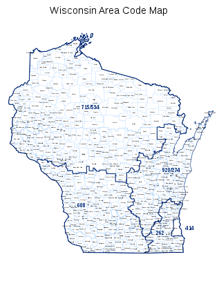
Area code 262 is a telephone area code in the North American Numbering Plan for the southeastern part of the U.S. state of Wisconsin. The numbering plan area comprises suburbs that are a part of the Milwaukee and Chicago metropolitan areas. The area code was created on September 25, 1999, in an area code split of area code 414.
Cedar Creek is a 53-kilometre-long (33 mi) stream in southeastern Wisconsin in the United States. The Cedar Creek watershed is a 330 km2 (127 mi2) sub-basin of the larger Milwaukee River watershed.
Waubeka is an unincorporated census-designated place in the Town of Fredonia, Ozaukee County, Wisconsin, United States. Located on the Milwaukee River, the community is part of the Milwaukee metropolitan area. As of the 2010 census, its population is 657.
The 59th Assembly District of Wisconsin is one of 99 districts in the Wisconsin State Assembly. Located in eastern Wisconsin, the district comprises parts of northern Washington County, northern Ozaukee County, southern Sheboygan County, northeast Dodge County, and southeast Fond du Lac County. It includes the villages of Adell, Belgium, Campbellsport, Cedar Grove, Eden, Fredonia, Kewaskum, Random Lake, Saukville, and Theresa, along with part of the city of West Bend. It also contains the University of Wisconsin–Milwaukee at Washington County campus, the West Bend campus of Moraine Park Technical College, Kettle Moraine State Forest Northern Unit, Cedarburg Bog, Harrington Beach State Park, and most of the Theresa Marsh. The district is represented by Republican Ty Bodden, since January 2023.
This page is based on this Wikipedia article Text is available under the CC BY-SA 4.0 license; additional terms may apply. Images, videos and audio are available under their respective licenses.