St. Francis, Wisconsin

Last updated

Saint Francis, Wisconsin
Motto: 
Where Your Heart Remains
Milwaukee County Wisconsin incorporated and unincorporated areas St. Francis highlighted.svg
Location of St. Francis in Milwaukee County, Wisconsin.
Coordinates: 42°58′11″N87°52′36″W / 42.96972°N 87.87667°W / 42.96972; -87.87667
Country Flag of the United States.svg  United States
State Flag of Wisconsin.svg  Wisconsin
County Milwaukee
Incorporated July 25, 1951;72 years ago (1951-07-25)
Government
   Mayor Ken Tutaj [1]
Area
[2]
  Total2.57 sq mi (6.65 km2)
  Land2.57 sq mi (6.65 km2)
  Water0.00 sq mi (0.00 km2)
Elevation
[3]
692 ft (211 m)
Population
 (2020) [4]
  Total9,161
  Estimate 
(2021) [5]
9,457
  Density3,776.87/sq mi (1,458.51/km2)
Time zone UTC-6 (Central (CST))
  Summer (DST) UTC-5 (CDT)
ZIP code
53235 [6]
Area code 414
FIPS code 55-70650 [7]
GNIS feature ID1572924 [3]
Website http://www.stfranciswi.org

St. Francis is a city in Milwaukee County, Wisconsin, United States. The population was 9,161 at the 2020 census.

Contents

History

St. Francis Seminary. St Francis Seminary.jpg
St. Francis Seminary.

The area that is now St. Francis was known as "Nojoshing" by local Native Americans at the time that the first white settlers arrived. [8] St. Francis Seminary was established in what is now the city in 1845. The Sisters of St. Francis of Assisi settled there in the mid-19th century. [8]

Historically, what is now the city of St. Francis was part of the Town of Lake. As large parts of the Town of Lake were gradually being annexed into the city of Milwaukee, residents in the St. Francis area sought to incorporate their community to prevent this from happening to them. A movement to split St. Francis off from the rest of the Town of Lake as a city existed as early as the 1920s, but faced resistance from residents of the rest of the town. Ultimately, the residents successfully voted to incorporate on July 24, 1951, and the result was certified the next day. The rest of the Town of Lake was annexed into Milwaukee in 1954. [8] [9]

The city took its name from St. Francis Seminary, founded by Archbishop John Henni, the first Archbishop of Milwaukee, who placed it under the patronage of Francis de Sales, the first Catholic bishop of Switzerland after the Swiss Reformation. [10]

Geography

St. Francis is located at 42°58′11″N87°52′36″W / 42.96972°N 87.87667°W / 42.96972; -87.87667 (42.969615, -87.876745). [11]

According to the United States Census Bureau, the city has a total area of 2.55 square miles (6.60 km2), all of it land. [12]

The city is located directly south and east of the City of Milwaukee, directly west of Lake Michigan, and directly north of Cudahy, Wisconsin. Milwaukee's primary airport, Milwaukee Mitchell International Airport, is bordered on one side by St. Francis. [13]

Demographics

Historical population
CensusPop.Note
1960 10,065
1970 10,4603.9%
1980 10,095−3.5%
1990 9,245−8.4%
2000 8,662−6.3%
2010 9,3638.1%
2020 9,161−2.2%
2021 (est.)9,457 [5] 3.2%
U.S. Decennial Census [4]

2010 census

As of the census [14] of 2010, there were 9,365 people, 4,494 households, and 2,210 families living in the city. The population density was 3,672.5 inhabitants per square mile (1,418.0/km2). There were 4,828 housing units at an average density of 1,893.3 per square mile (731.0/km2). The racial makeup of the city was 88.8% White, 2.7% African American, 1.0% Native American, 2.1% Asian, 2.8% from other races, and 2.5% from two or more races. Hispanic or Latino of any race were 9.4% of the population.

There were 4,494 households, of which 19.8% had children under the age of 18 living with them, 36.6% were married couples living together, 8.7% had a female householder with no husband present, 3.9% had a male householder with no wife present, and 50.8% were non-families. 42.6% of all households were made up of individuals, and 13.7% had someone living alone who was 65 years of age or older. The average household size was 2.02 and the average family size was 2.80.

The median age in the city was 42 years. 15.9% of residents were under the age of 18; 8.6% were between the ages of 18 and 24; 29.3% were from 25 to 44; 28.8% were from 45 to 64; and 17.5% were 65 years of age or older. The gender makeup of the city was 48.6% male and 51.4% female.

2000 census

As of the census [7] of 2000, there were 8,662 people, 4,050 households, and 2,158 families living in the city. The population density was 3,421.7 people per square mile (1,321.9/km2). There were 4,193 housing units at an average density of 1,656.4 per square mile (639.9/km2). The racial makeup of the city was 93.77% White, 0.97% African American, 0.88% Native American, 1.05% Asian, 0.02% Pacific Islander, 1.50% from other races, and 1.81% from two or more races. Hispanic or Latino of any race were 4.53% of the population.

There were 4,050 households, out of which 21.8% had children under the age of 18 living with them, 41.0% were married couples living together, 8.7% had a female householder with no husband present, and 46.7% were non-families. 40.8% of all households were made up of individuals, and 13.9% had someone living alone who was 65 years of age or older. The average household size was 2.11 and the average family size was 2.88.

In the city, the population was spread out, with 19.3% under the age of 18, 8.9% from 18 to 24, 30.9% from 25 to 44, 23.0% from 45 to 64, and 17.9% who were 65 years of age or older. The median age was 40 years. For every 100 females, there were 96.1 males. For every 100 females age 18 and over, there were 92.7 males.

The median income for a household in the city was $36,721, and the median income for a family was $49,896. Males had a median income of $37,013 versus $27,129 for females. The per capita income for the city was $21,837. About 2.7% of families and 6.5% of the population were below the poverty line, including 4.6% of those under age 18 and 14.1% of those age 65 or over.

Education

The Saint Francis School District, which provides public education for the area, includes three schools: [15] [16]

Notable residents

Related Research Articles

<span class="mw-page-title-main">Morganton, Georgia</span> City in Georgia, United States

Morganton is a city in Fannin County, Georgia, United States. The population was 285 at the 2020 census.

<span class="mw-page-title-main">St. Francis, Kansas</span> City in Cheyenne County, Kansas

St. Francis is a city in and the county seat of Cheyenne County, Kansas, United States. As of the 2020 census, the population of the city was 1,263.

<span class="mw-page-title-main">Union Township, Schuylkill County, Pennsylvania</span> Township in Pennsylvania, United States

Union Township is a township that is located in Schuylkill County, Pennsylvania, United States. The population was 1,231 at the time of the 2020 census.

<span class="mw-page-title-main">Pittsfield Township, Pennsylvania</span> Township in Pennsylvania, United States

Pittsfield Township is a township in Warren County, Pennsylvania, United States. The population was 1,283 at the 2020 census, down from 1,405 at the 2010 census. 1,519 at the 2000 census.

<span class="mw-page-title-main">Valley Falls, Rhode Island</span> Village and census-designated place in Rhode Island, US

Valley Falls is a village and census-designated place (CDP) in the town of Cumberland, Providence County, Rhode Island, United States. The population was 12,094 at the 2020 census.

<span class="mw-page-title-main">Juneau, Wisconsin</span> City in Wisconsin, United States

Juneau is a city in Dodge County, Wisconsin, United States. The population was 2,658 at the 2020 census. It is the county seat of Dodge County.

<span class="mw-page-title-main">Cudahy, Wisconsin</span> City in Wisconsin, United States

Cudahy is a city in Milwaukee County, Wisconsin, United States. The population was 18,204 at the 2020 census.

<span class="mw-page-title-main">Glendale, Wisconsin</span> City in Milwaukee County, Wisconsin

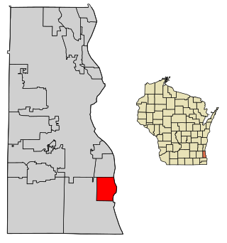
Glendale is a city in Milwaukee County, Wisconsin, United States. It is a suburb of the neighboring Milwaukee. The population was 13,357 at the 2020 census.

<span class="mw-page-title-main">South Milwaukee, Wisconsin</span> City in Wisconsin, United States

South Milwaukee is a city in Milwaukee County, Wisconsin, United States. The population was 20,795 at the 2020 census.

<span class="mw-page-title-main">Cashton, Wisconsin</span> Village in Wisconsin, United States

Cashton is a village in Monroe County, Wisconsin, United States. The population was 1,158 at the 2020 census.

<span class="mw-page-title-main">Union Grove, Wisconsin</span> Village in Wisconsin, United States

Union Grove is a village in Racine County, Wisconsin, United States. The population was 4,806 at the 2020 census.

<span class="mw-page-title-main">Elkhorn, Wisconsin</span> City in Wisconsin, United States

Elkhorn is a city in Walworth County, Wisconsin, United States. It is located 40 miles (64 km) southwest of Milwaukee. As of the 2020 census, it was home to 10,247 people, up from 10,084 at the 2010 census. It is the county seat.

<span class="mw-page-title-main">Montfort, Wisconsin</span> Village in Wisconsin, United States

Montfort is a village in Grant and Iowa Counties in the U.S. state of Wisconsin. The population was 718 at the 2010 census. Of this, 622 were in Grant County, and 96 were in Iowa County.

<span class="mw-page-title-main">Genoa City, Wisconsin</span> Village in Wisconsin, United States

Genoa City is a village located in Kenosha and Walworth counties in the U.S. state of Wisconsin, 43 mi (69 km) south-southwest of Milwaukee, located on the Illinois–Wisconsin border. The population was 2,982 at the 2020 census. It was named after Genoa, New York, which was named after Genoa in Italy.

<span class="mw-page-title-main">Newburg, Wisconsin</span> Village in Ozaukee and Washington counties, Wisconsin

Newburg is a village in Ozaukee and Washington counties in the U.S. state of Wisconsin. The population was 1,254 at the 2010 census. Of this, 1,157 were in Washington County, and only 97 were in Ozaukee County.

<span class="mw-page-title-main">Adams, Wisconsin</span> City in Wisconsin, United States

Adams is a city in Adams County in the U.S. state of Wisconsin. The population was 1,761 at the 2020 census. The city is located within the Town of Adams.

<span class="mw-page-title-main">Boscobel, Wisconsin</span> City in Wisconsin, United States

Boscobel is a city in Grant County, Wisconsin, United States. The population was 3,286 at the 2020 census. Approximately 0.6 mi. (1 km) to the north of the city, across a riparian swamp, is the Wisconsin River. U.S. Route 61 crosses the Wisconsin River at Boscobel. To the south, the city is bordered by the Town of Boscobel.

<span class="mw-page-title-main">Darien, Wisconsin</span> Village in Wisconsin, United States

Darien is a village in Walworth County, Wisconsin, United States. The population was 1,573 at the 2020 census. The village is located within the Town of Darien.

<span class="mw-page-title-main">Delafield, Wisconsin</span> Place in Wisconsin, United States

Delafield is a city in Waukesha County, Wisconsin, along the Bark River. The population was 7,085 at the 2010 census.

<span class="mw-page-title-main">Pewaukee, Wisconsin</span> City in Wisconsin, United States

Pewaukee is a city in Waukesha County, Wisconsin. The population was 15,914 at the 2020 census. The Village of Pewaukee, which was incorporated out of the town before it incorporated as a city, is surrounded by the city.

References

  1. Mayor. City of St. Francis.
  2. "2019 U.S. Gazetteer Files". United States Census Bureau. Retrieved August 7, 2020.
  3. 1 2 "US Board on Geographic Names". United States Geological Survey. October 25, 2007. Retrieved January 31, 2008.
  4. 1 2 "Census of Population and Housing". Census.gov. Retrieved August 10, 2022.
  5. 1 2 "Population and Housing Unit Estimates". United States Census Bureau. May 16, 2022. Retrieved August 10, 2022.
  6. "Saint Francis ZIP Code". zipdatamaps.com. 2022. Retrieved November 30, 2022.
  7. 1 2 "U.S. Census website". United States Census Bureau . Retrieved January 31, 2008.
  8. 1 2 3 "City of St. Francis", Encyclopedia of Milwaukee.
  9. Chicago and North Western Railway Company (1908). A History of the Origin of the Place Names Connected with the Chicago & North Western and Chicago, St. Paul, Minneapolis & Omaha Railways. p. 121.
  10. "US Gazetteer files: 2010, 2000, and 1990". United States Census Bureau. February 12, 2011. Retrieved April 23, 2011.
  11. "US Gazetteer files 2010". United States Census Bureau. Archived from the original on January 25, 2012. Retrieved November 18, 2012.
  12. OpenStreetMap contributors (November 22, 2023). "St. Francis" (Map). OpenStreetMap . Retrieved November 22, 2023.
  13. "U.S. Census website". United States Census Bureau . Retrieved November 18, 2012.
  14. "St. Francis School District - Schools Home". www.stfrancisschools.org. Retrieved March 17, 2019.
  15. "Search for Public Schools - Saint Francis School District". National Center for Education Statistics . Retrieved November 22, 2023.