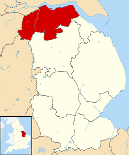
Lincolnshire is a county in eastern England, with a long coastline on the North Sea to the east. It borders Norfolk to the south east, Cambridgeshire to the south, Rutland to the south west, Leicestershire and Nottinghamshire to the west, South Yorkshire to the north west, and the East Riding of Yorkshire to the north. It also borders Northamptonshire in the south for just 20 yards (18 m), England's shortest county boundary. The county town is the city of Lincoln, where the county council has its headquarters.

Hatton is a small village and civil parish in the East Lindsey district of Lincolnshire, England. It is situated 3 miles (5 km) east from the town of Wragby, 6 miles (10 km) north-west from the town of Horncastle, and just north from the A158 road.

Tetney is a village in the East Lindsey district of Lincolnshire, England, and just west of the Prime Meridian.

Messingham is a village and civil parish in North Lincolnshire, England.

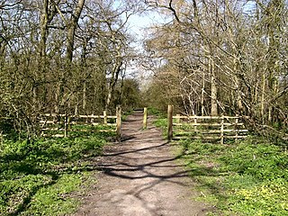
Atkinsons Warren is a large area of woodland in northwest Scunthorpe, North Lincolnshire, England. It is a Local Nature Reserve, and includes a meadow grazed by rabbits, rough grassland, developing scrub, and birch and oak woodland. It also features tree carvings. The Warren can be publicly accessed on foot or by car, and is used for walking dogs and riding bicycles.
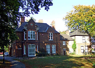
North Lincolnshire Museum is a local museum in the town of Scunthorpe, north Lincolnshire, England.

Frodingham was a hamlet in Lincolnshire which has grown into a suburb of Scunthorpe, North Lincolnshire. Although the village lay directly to the south of what is now Scunthorpe town centre, the name Frodingham is now often used to refer to the area directly to the north of the town centre.

Scunthorpe General Hospital is the main hospital for North Lincolnshire. It is situated on Church Lane in the west of Scunthorpe, off Kingsway (A18), and north of the railway. A & E is at the far north of the site, accessed via Highfield Avenue, off Doncaster Road (A1029). As well as North Lincolnshire, it also serves Gainsborough. It is managed by Northern Lincolnshire and Goole Hospitals NHS Foundation Trust.

The Iron and Steel Industry in Scunthorpe was established in the mid 19th century, following the discovery and exploitation of middle Lias ironstone east of Scunthorpe, Lincolnshire, England.
Outwood Academy Brumby, is a mixed secondary school with academy status, in Scunthorpe (Brumby), North Lincolnshire, England.

Scunthorpe was an Urban District from 1894 to 1919 and Municipal Borough from 1919 to 1974 in Parts of Lindsey, Lincolnshire, England.
Axholme Line–Haxey is a 7.23-hectare Local Nature Reserve near the village of Haxey in North Lincolnshire. It is owned and managed by North Lincolnshire Council. It is composed of neutral calcareous grassland encompassing a stretch of the disused Axholme Joint Railway which runs from Haxey to land adjacent to Low Burnham. The site can be accessed by the public opposite Haxey Primary School.
Bradley and Dixon Woods is a 41.77-hectare Local Nature Reserve near the town of Grimsby in North East Lincolnshire. It is owned and managed by North East Lincolnshire Council. It is composed of ancient woodland, meadows, ponds and bird feeding sites, and is located south-west of Grimsby and south of the village of Bradley; the site is bounded to the north by Woodlands Farm and Bradley Woodlands Independent Hospital. The LNR can be accessed by the public via the B1444 off the A46 road.

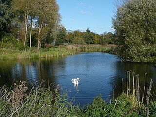
Cleethorpes Country Park is a 62.01 hectares (0.6201 km2) Local Nature Reserve situated between the town of Cleethorpes and the village of Humberston in North East Lincolnshire. It is owned and managed by North East Lincolnshire Council. It is composed of woodland, grassland and a lake. The site is a good habitat for wildflowers, invertebrates, wildfowl and skylarks. Over winter, wading birds roost on the park at high tide. The LNR is bounded to the north by Cleethorpes, and forms the northern boundary of Humberston's residential area; it is bounded to the west by the A1031 road and to the east by Cleethorpes Golf Club.
Lollycocks Field is a 2.15-hectare Local Nature Reserve in Sleaford, a market town and civil parish in the North Kesteven district of Lincolnshire. It is owned by North Kesteven District Council and managed jointly by Leisure Connection and rangers from Hill Holt Wood. Lollycocks Field provides mostly wildflower and wetlands habitats; its pond attracts range of wildlife. It is bounded to the north by Eastgate, to the east by the North Kesteven District Council offices and car park, and to the south by the River Slea. It is just east of Cogglesford Mill. The site can be accessed by the public from Eastgate, and car parks are located on East Road, further into the town and also off East Banks.
Mareham Pastures is an 11-hectare Local Nature Reserve in Sleaford, a market town and civil parish in the North Kesteven district of Lincolnshire. It is owned by Lincolnshire County Council and managed jointly by Lincolnshire County Council and the Friends of Mareham Pastures. The reserve consists of wildflower meadows, new woodland, hedges and open grassland, providing a good habitat for butterflies and potentially barn owls; it is located westwards off Mareham Lane and is bounded to the north and north-west by residential developments at Quarrington and by farmland to the south; it is adjacent to a disused recycling centre, situated to its east. The site can be accessed by the public on foot via Bullock Pastures Lane, which begins at Sleaford Cricket Ground off London Road; visitors travelling by car can park next to the former recycling centre off Mareham Lane and gain access that way.
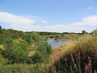
Stanton's Pit is an 8.05-hectare Local Nature Reserve situated between Little Bytham and Witham-on-the-Hill, villages in the South Kesteven district of Lincolnshire. It is owned and managed by Lincolnshire Wildlife Trust. The reserve mostly comprises a disused sand pit with adjacent grasslands which was donated by its former owner to the Lincolnshire Wildlife Trust so that it could be classified as a Local Nature Reserve. It has been designated as such on the basis of its ornithological interest, with 50 species of birds recorded visiting the site and 19 breeding, including little grebe, little ringed plover, sand martin, turtle dove and lesser whitethroat. Wading birds known to occupy the site in autumn include little stint, ruff and spotted redshank, greenshank, and common, curlew, green and wood sandpipers. Stanton's Pit is suspected to be situated on a migratory route from The Wash to Rutland Water. The site is bounded to the north by a minor road between Little Bytham and Witham-on-the-Hill, to the south and west by farmland and to the east by Bush Lees wood.