Havenside

Last updated
Havenside
Type Local Nature Reserve
Location Fishtoft, Lincolnshire
OS grid TF 351 413
Area 18.91 hectares

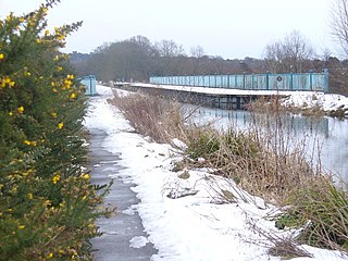
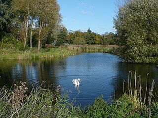
Havenside is an 18.91-hectare Local Nature Reserve in Fishtoft, a civil parish in the Boston borough of Lincolnshire. [1] It is a thin piece of land along the eastern edge of The Haven (a stretch of the River Witham), running southwards from the built-up area around Skirbeck (within Fishtoft's parish boundaries but separate from the village of Fishtoft) to a point just north of the junction where Hobhole Drain merges with The Haven; the reserve is mostly bounded to the east by fields, but is backed onto by residential and industrial buildings at Skirbeck and is adjacent to a sewerage works further south. It contains a mixture of rough grassland with scrub and brambles, cattle-grazed meadows, seasonal ponds, estuary, and mud flats. It also contains the Pilgrim Fathers' Memorial on the site (formerly called Scotia Creek) where a group of puritans were arrested in 1607 while trying to escape religious persecution. [1] [2] The reserve's main entrance is near Finn Forest's works on the industrial estate off Fishtoft Road, Skirbeck. Another car park is off Scalp Road in Fishtoft village. [1] [2]

Fishtoft village and civil parish in Lincolnshire, England

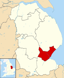
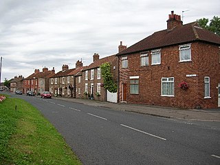
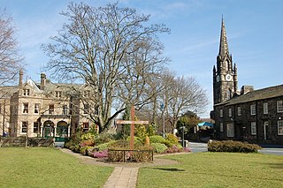
Fishtoft is one of eighteen civil parishes which, together with Boston, form the Borough of Boston in the county of Lincolnshire, England. Local government has been arranged in this way since the reorganization of 1 April 1974, which resulted from the Local Government Act 1972. This parish forms an electoral ward in itself. Hitherto, the parish had formed part of Boston Rural District, in the Parts of Holland. Holland was one of the three divisions of the traditional county of Lincolnshire. Since the Local Government Act of 1888, Holland had been in most respects, a county in itself. The population of the civil parish at the 2011 census was 6,835.

Lincolnshire County of England

Lincolnshire is a county in eastern England, with a long coastline on the North Sea to the east. It borders Norfolk to the south east, Cambridgeshire to the south, Rutland to the south west, Leicestershire and Nottinghamshire to the west, South Yorkshire to the north west, and the East Riding of Yorkshire to the north. It also borders Northamptonshire in the south for just 20 yards (18 m), England's shortest county boundary. The county town is the city of Lincoln, where the county council has its headquarters.

River Witham river in east of England

The River Witham is a river almost entirely in the county of Lincolnshire in the east of England. It rises south of Grantham close to South Witham at SK8818, passes Lincoln at SK9771 and at Boston, TF3244, flows into The Haven, a tidal arm of The Wash, near RSPB Frampton Marsh. The name "Witham" seems to be extremely old and of unknown origin. Archaeological and documentary evidence shows the importance of the Witham as a navigable river from the Iron Age onwards. From Roman times it was navigable to Lincoln, from where the Fossdyke was constructed to link it to the River Trent. The mouth of the river moved in 1014 following severe flooding, and Boston became important as a port.

Related Research Articles

Boston, Lincolnshire town in Lincolnshire, England

Boston is a town and small port in Lincolnshire, on the east coast of England, approximately 100 miles (160 km) north of London. It is the largest town of the wider Borough of Boston local government district. The town itself had a population of 35,124 at the 2001 census, while the borough had a total population of 66,900, at the ONS mid-2015 estimates. It is due north of Greenwich on the Prime Meridian.

Borough of Boston Borough in England

The Borough of Boston is a local government district with borough status in Lincolnshire, England. Its council is based in the town of Boston.

Dunnington village in United Kingdom

Dunnington is a village and civil parish in the City of York and ceremonial county of North Yorkshire, England. The population of the civil parish was 3,230 at the 2011 Census. The village is approximately 4 miles (6 km) east from York city centre.

Thurmaston farm village in the United Kingdom

Thurmaston is a village and civil parish in Leicestershire, England, located within the Borough of Charnwood. At the 2011 census, it had a population of 9,668.

Saltfleetby village in the United Kingdom

Saltfleetby is a village and civil parish in the East Lindsey district of Lincolnshire, England. It is on the coast of the North Sea, approximately 7 miles (11 km) east from Louth and 10 miles (16 km) north from Mablethorpe. The parish had a population of 599 in the 2001 Census, decreasing to 568 at the 2011 Census.

Babcary village in the United Kingdom

Babcary is a village and parish in Somerset, England, situated 5 miles (8.0 km) east of Somerton and 6 miles (9.7 km) south west of Castle Cary in the South Somerset district. The village has a population of 248. It lies close to the River Cary and the A37.

Hooe, East Sussex village in the United Kingdom

Hooe is both a small village and a civil parish in the Wealden District of East Sussex; the village being located about two miles (3 km) north-west of Bexhill, and north of the A259 coast road, on the B2095 road from Ninfield. The parish name takes account of local usage, and the location of the parish church; in fact the main population centre is to the north, and is called Hooe Common.

Burley in Wharfedale village in the United Kingdom

Burley in Wharfedale is a village and civil parish in the county of West Yorkshire, England, and is situated within the Wharfedale valley.

Netherton, West Midlands human settlement in United Kingdom

Netherton is an area of the Metropolitan Borough of Dudley, 1.5 miles (2 km) south of Dudley town centre in the West Midlands of England, but historically in Worcestershire. In the Black Country, Netherton is bordered by nature reserves to the east and west, and an industrial area and the Dudley Southern By-Pass to the north.

Ash Vale village in Surrey, England

Ash Vale is a village in the borough of Guildford in Surrey, England and the larger, northern settlement of the civil parish of Ash. It is 7 miles (11 km) from Guildford but is closer to the Hampshire towns of Aldershot and Farnborough, the centres of which are each about two miles (4 km) away, immediately across the two crossings of the River Blackwater, to the southwest and northwest.

Rodney Stoke a village located in Mendip, United Kingdom

Rodney Stoke is a small village and civil parish, located at grid reference ST486501, 5 miles north-west of Wells, in the English county of Somerset. The village is on the A371 between Draycott and Westbury-sub-Mendip.

Ebernoe village in United Kingdom

Ebernoe is a hamlet and civil parish in the District of Chichester in West Sussex, England located six kilometres (4 miles) north of Petworth near the A283 road.

Tetney a village located in East Lindsey, United Kingdom

Tetney is a village in the East Lindsey district of Lincolnshire, England, and just west of the Prime Meridian.

West Thorney village and civil parish in West Sussex, England

West Thorney is a village and civil parish in the District of Chichester in West Sussex, England located nine kilometres (5.4 miles) west of Chichester south of the A27 road.

Leyton Marsh

Leyton Marsh is located in Leyton in the London Borough of Waltham Forest.

Upton Warren village in United Kingdom

Upton Warren is a village and civil parish in the Wychavon district, in Worcestershire, England. The village is situated just off the A38 road between Bromsgrove and Droitwich Spa, and on the River Salwarpe. In the 2001 census, the parish, which also contains the small hamlet of Cooksey Green, had a population of 291.

Pepper Gowt Plot hamlet in Lincolnshire, England

Pepper Gowt Plot, also known as Rowlands Marsh, was a hamlet and small tract of extra-parochial land, created when the River Witham was straightened in the early 19th century, and lies about 2 miles (3 km) north of the town of Boston, Lincolnshire, England, and immediately south of Anton's Gowt.

Lollycocks Field

Lollycocks Field is a 2.15-hectare Local Nature Reserve in Sleaford, a market town and civil parish in the North Kesteven district of Lincolnshire. It is owned by North Kesteven District Council and managed jointly by Leisure Connection and rangers from Hill Holt Wood. Lollycocks Field provides mostly wildflower and wetlands habitats; its pond attracts range of wildlife. It is bounded to the north by Eastgate, to the east by the North Kesteven District Council offices and car park, and to the south by the River Slea. It is just east of Cogglesford Mill. The site can be accessed by the public from Eastgate, and car parks are located on East Road, further into the town and also off East Banks.

Mareham Pastures is an 11-hectare Local Nature Reserve in Sleaford, a market town and civil parish in the North Kesteven district of Lincolnshire. It is owned by Lincolnshire County Council and managed jointly by Lincolnshire County Council and the Friends of Mareham Pastures. The reserve consists of wildflower meadows, new woodland, hedges and open grassland, providing a good habitat for butterflies and potentially barn owls; it is located westwards off Mareham Lane and is bounded to the north and north-west by residential developments at Quarrington and by farmland to the south; it is adjacent to a disused recycling centre, situated to its east. The site can be accessed by the public on foot via Bullock Pastures Lane, which begins at Sleaford Cricket Ground off London Road; visitors travelling by car can park next to the former recycling centre off Mareham Lane and gain access that way.

References

  1. 1 2 3 "Havenside". Local Nature Reserves. Natural England. Retrieved 28 January 2018.
  2. 1 2 "Magic Map". Department for the Environment, Food and Rural Affairs. Retrieved 28 January 2018.