The A15 is a major road in England. It runs north from Peterborough via Market Deeping, Bourne, Sleaford and Lincoln along a variety of ancient, Roman, and Turnpike alignments before it is interrupted at its junction with the M180 near Scawby. The road restarts 10 miles (16 km) east, and then continues north past Barton-upon-Humber, crossing the Humber on the Humber Bridge before terminating at Hessle near Kingston upon Hull.

Saltfleetby is a village and civil parish in the East Lindsey district of Lincolnshire, England. It is on the coast of the North Sea, approximately 7 miles (11 km) east from Louth and 10 miles (16 km) north from Mablethorpe. The parish had a population of 599 in the 2001 Census, decreasing to 568 at the 2011 Census.

Sleaford and North Hykeham is a constituency in the House of Commons of the UK Parliament. It has been represented since December 2016 by Dr Caroline Johnson, a Conservative.

Ruskington is a large village and civil parish in the North Kesteven district of Lincolnshire, England, located on the north-south B1188 road and slightly north of the A153 road. The village contains approximately 2,200 dwellings and is approximately 1 mile (1.6 km) in length, measured from east to west. The population of the civil parish was 5,169 at the 2001 census, increasing to 5,637 at the 2011 census.

The Yorkshire Wildlife Trust is a wildlife trust that covers the Yorkshire and the Humber region of England. When it was founded, it covered the traditional county of Yorkshire, England, but under the 1974 county boundary changes, some of the trust's boundaries were amended to reflect those changes. The Trust is part of the UK-wide partnership of 47 Wildlife Trusts. It was formed in 1946, as the Yorkshire Naturalists’ Trust, essentially to preserve its first nature reserve Askham Bog on the outskirts of York. It now manages more than ninety reserves across the county, including some of the best wildlife sites in the UK. These nature reserves cover the diversity of Yorkshire’s landscape, from woodland to grassland, wetland and moorland, fen and bog, and river and coast. One of the flagship reserves is Potteric Carr, a mixed wetland habitat to the south of Doncaster.
Navenby is a village and civil parish in Lincolnshire, England. Lying 8 miles (13 km) south from the county town of Lincoln and 9 miles (14 km) north-northwest from Sleaford, Navenby had a population of 2,128 at the time of the 2011 census and is a dormitory village for Lincoln. It forms part of the North Kesteven local government district and, in March 2011, it was named as the 'Best Value Village' in England following a national survey.

Burton Pedwardine is a hamlet and civil parish in the district of North Kesteven, Lincolnshire, England. The population at the 2011 census was 187. The hamlet is situated approximately 4 miles (6 km) south-east from the market town of Sleaford and south-west of the village of Heckington.

The Sleaford Navigation was a 12.5 mile (20.1 km) canalisation of the River Slea in Lincolnshire, England, which opened in 1794. It ran from a junction with the River Witham, near Chapel Hill to the town of Sleaford through seven locks, most of which were adjacent to mills. Lack of finance meant that it stopped short of its intended terminus, but it gradually grew to be successful financially. The coming of the railways in 1857 led to a rapid decline, and it was officially abandoned by an act of Parliament in 1878, but remained open for a further three years. The lower part of it remained navigable until the 1940s, when it was blocked by a sluice.

Stow Fair was an English medieval fair inaugurated in 1233. The Prior of Sempringham was granted permission in 1268 to hold this annual fair, from 23–25 June, confirming an earlier charter. The fair continued until living memory, being run as a horse fair until 1954.

St George's Academy is a co-educational comprehensive secondary school based in the English market town of Sleaford in Lincolnshire, with a satellite school at nearby Ruskington. Its origins date to 1908, when Sleaford Council School opened at Church Lane to meet the growing demand for elementary education in the town. After the Education Act 1944, the senior department became a secondary modern. A second school building was constructed at Westholme in the 1950s and expanded in 1983, allowing the Church Lane site to close; to mark the occasion, it was renamed St George's School. After it became grant-maintained, the school became a comprehensive, received a Technology specialism, became a Technology College in 1994 and later converted to Foundation status. Coteland's School in Ruskington federated with St George's in 2007; they merged to form the Academy in 2010.

Quarrington is a village and former civil parish, now part of the civil parish of Sleaford, in the North Kesteven district of Lincolnshire, a non-metropolitan county in the East Midlands of England. The old village and its church lie approximately 1.2 miles (2 km) south-west from the centre of Sleaford, the nearest market town, but suburban housing developments at New Quarrington and Quarrington Hill effectively link the two settlements. Bypassed by the A15, it is connected to Lincoln and Peterborough, as well as Newark and King's Lynn. At the 2011 Census, Quarrington and Mareham ward, which incorporates most of the settlement, had an estimated population of 7,046.
Mareham Lane is an unclassified road between Graby and Sleaford in Lincolnshire, England. It is approximately 10.6 miles (17.1 km) long.
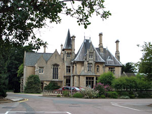
Westholme House is a historic building in the English market town of Sleaford in Lincolnshire, set in 32 acres of parkland and school grounds. Built around 1849 in the style of a French Gothic mansion by Charles Kirk for his business partner Thomas Parry, it was privately owned until the 1940s, when Kesteven County Council acquired the house and its grounds. It subsequently served as the county library and part of Sleaford Secondary Modern School. The stone house follows an asymmetrical layout and incorporates a range of Gothic elements in its design. In 1974, it was recorded in the National Heritage List for England as a designated Grade II listed building, recognising it as of "special interest".

The Bass Maltings in Sleaford, England are a large group of eight disused malt houses originally owned by the Bass Brewery of Burton upon Trent. Constructed between 1901 and 1907 to Herbert A. Couchman's design, the maltings are the largest group of malt houses in England; they have been designated Grade II* on the National Heritage List for England, recognising them as "particularly important ... of more than special interest."
Axholme Line–Haxey is a 7.23-hectare Local Nature Reserve near the village of Haxey in North Lincolnshire. It is owned and managed by North Lincolnshire Council. It is composed of neutral calcareous grassland encompassing a stretch of the disused Axholme Joint Railway which runs from Haxey to land adjacent to Low Burnham. The site can be accessed by the public opposite Haxey Primary School.
Bradley and Dixon Woods is a 41.77-hectare Local Nature Reserve near the town of Grimsby in North East Lincolnshire. It is owned and managed by North East Lincolnshire Council. It is composed of ancient woodland, meadows, ponds and bird feeding sites, and is located south-west of Grimsby and south of the village of Bradley; the site is bounded to the north by Woodlands Farm and Bradley Woodlands Independent Hospital. The LNR can be accessed by the public via the B1444 off the A46 road. The woods are the subject of local folklore.
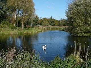
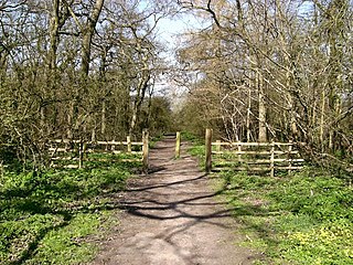
Lollycocks Field is a 2.15-hectare Local Nature Reserve in Sleaford, a market town and civil parish in the North Kesteven district of Lincolnshire. It is owned by North Kesteven District Council and managed jointly by Leisure Connection and rangers from Hill Holt Wood. Lollycocks Field provides mostly wildflower and wetlands habitats; its pond attracts range of wildlife. It is bounded to the north by Eastgate, to the east by the North Kesteven District Council offices and car park, and to the south by the River Slea. It is just east of Cogglesford Mill. The site can be accessed by the public from Eastgate, and car parks are located on East Road, further into the town and also off East Banks.