
Lincolnshire is a county in the East Midlands of England, with a long coastline on the North Sea to the east. It borders Norfolk to the south-east, Cambridgeshire to the south, Rutland to the south-west, Leicestershire and Nottinghamshire to the west, South Yorkshire to the north-west, and the East Riding of Yorkshire to the north. It also borders Northamptonshire in the south for just 20 yards (19 m), England's shortest county boundary. The county town is the city of Lincoln, where the county council has its headquarters.

Bradley Stoke is a newly developed and planned town in South Gloucestershire, England, situated on the north side of the city of Bristol, 6 miles northeast of Bristol city centre and 103 miles (166 km) due west of London. Not far from the Severn Estuary of the Bristol Channel, Bradley Stoke is bordered by three motorways; the M5 to the north, the M4 to the east and the M32 to the south.

North East Lincolnshire is a unitary authority area in the ceremonial county of Lincolnshire in England. It borders the unitary authority of North Lincolnshire and the non-metropolitan county of Lincolnshire, the three areas making up the ceremonial county. The population of the Unitary Authority at the 2011 Census was 159,616. North East Lincolnshire is part of the Yorkshire and the Humber region.
The Lincolnshire Wildlife Trust,, covers the whole ceremonial county of Lincolnshire, England. It was founded in 1948 as a voluntary charitable organisation dedicated to conserving the wildlife and wild places of Lincolnshire and to promoting the understanding and enjoyment of the natural world.

Kent Wildlife Trust (KWT) is a conservation charity in the United Kingdom that was founded in 1958, previously known as the Kent Trust for Nature Conservation. It aims to "work with people to restore, save and improve our natural spaces" and to "ensure that 30% of Kent and Medway – land and sea – is managed to create a healthy place for wildlife to flourish". In 2016 it had thirty-one thousand members and an annual income of £4 million. KWT manages fifty-four nature reserves, of which twenty-four are Sites of Special Scientific Interest, two are National Nature Reserves, nine are Nature Conservation Review sites, seven are Special Areas of Conservation, three are Special Protection Areas, seven are Local Nature Reserves, one is a Geological Conservation Review site, thirteen are in Areas of Outstanding Natural Beauty and one is a Scheduled Monument.

Nunsthorpe is a suburb and housing estate in the western part of Grimsby, North East Lincolnshire, England. It is situated between Laceby Road (A46) and Scartho Road (A1243), which respectively form its northern and eastern boundaries. The population is listed in the South ward of the North East Lincolnshire Unitary Council.

Bradley is a village and civil parish in North East Lincolnshire, England. It is situated approximately 3 miles (5 km) south-west from Grimsby and 2 miles (3 km) north from Barnoldby le Beck. Its population recorded in the census for both 2001 and 2011 was 198.
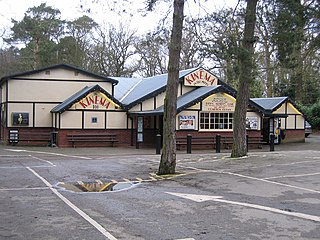
Woodhall Spa is a former spa town and civil parish in Lincolnshire, England, on the southern edge of the Lincolnshire Wolds, 6 miles (10 km) south-west of Horncastle, 23 miles (37 km) west of Skegness, 15 miles (24 km) east-south-east of Lincoln and 17 miles (27 km) north-west of Boston. It is noted for its mineral springs, cinema and its Second World War association with the RAF 617 Squadron. The cinema has the last remaining rear screen projector in the country.

Little Coates is an area of western Grimsby, North East Lincolnshire, England. It is in the Yarborough ward of the North East Lincolnshire Unitary Council.

Castle Bytham is a village and civil parish of around 300 houses in South Kesteven, Lincolnshire, England. It is located 9 miles (15 km) north of Stamford and 9 miles (15 km) west of Bourne.The population was measured at 768 in 317 households at the 2011 census.

Tetney is a village in the East Lindsey district of Lincolnshire, England, and just west of the Prime Meridian.

Sheepleas is a 99.9-hectare (247-acre) biological and geological Site of Special Scientific Interest east of Guildford in Surrey. It is a Geological Conservation Review site and a Local Nature Reserve. It is owned by Surrey County Council and managed by the Surrey Wildlife Trust.
Bradley Wood is an English footballer.

Tumby is a village in the East Lindsey district of Lincolnshire, England. It is situated approximately 2 miles (3.2 km) north from Coningsby and 6.5 miles (10.5 km) south from Horncastle, and in the civil parish of Kirkby on Bain.

Brumby Wood is a 21.84-hectare Local Nature Reserve in the town of Scunthorpe in North Lincolnshire. It is owned and managed by North Lincolnshire Council. It is composed of ancient woodland which provides a good habitat for birds, mammals, invertebrates, bluebell, wild garlic and yellow archangel; the site is located in Scunthorpe and is bounded to the north by the South Humberside Main Line railway, to the east and west by playing fields and to the south by an industrial site, a crematorium and a cemetery; the wood is bisected by the A18 road.

Cleethorpes Country Park is a 62.01 hectares (0.6201 km2) Local Nature Reserve situated between the town of Cleethorpes and the village of Humberston in North East Lincolnshire. It is owned and managed by North East Lincolnshire Council. It is composed of woodland, grassland and a lake. The site is a good habitat for wildflowers, invertebrates, wildfowl and skylarks. Over winter, wading birds roost on the park at high tide. The LNR is bounded to the north by Cleethorpes, and forms the northern boundary of Humberston's residential area; it is bounded to the west by the A1031 road and to the east by Cleethorpes Golf Club.
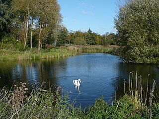
Lollycocks Field is a 2.15-hectare Local Nature Reserve in Sleaford, a market town and civil parish in the North Kesteven district of Lincolnshire. It is owned by North Kesteven District Council and managed jointly by Leisure Connection and rangers from Hill Holt Wood. Lollycocks Field provides mostly wildflower and wetlands habitats; its pond attracts range of wildlife. It is bounded to the north by Eastgate, to the east by the North Kesteven District Council offices and car park, and to the south by the River Slea. It is just east of Cogglesford Mill. The site can be accessed by the public from Eastgate, and car parks are located on East Road, further into the town and also off East Banks.
Mareham Pastures is an 11-hectare Local Nature Reserve in Sleaford, a market town and civil parish in the North Kesteven district of Lincolnshire. It is owned by Lincolnshire County Council and managed jointly by Lincolnshire County Council and the Friends of Mareham Pastures. The reserve consists of wildflower meadows, new woodland, hedges and open grassland, providing a good habitat for butterflies and potentially barn owls; it is located westwards off Mareham Lane and is bounded to the north and north-west by residential developments at Quarrington and by farmland to the south; it is adjacent to a disused recycling centre, situated to its east. The site can be accessed by the public on foot via Bullock Pastures Lane, which begins at Sleaford Cricket Ground off London Road; visitors travelling by car can park next to the former recycling centre off Mareham Lane and gain access that way.
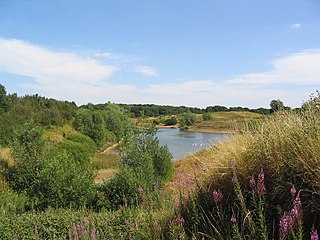
Stanton's Pit is an 8.05-hectare Local Nature Reserve situated between Little Bytham and Witham-on-the-Hill, villages in the South Kesteven district of Lincolnshire. It is owned and managed by Lincolnshire Wildlife Trust. The reserve mostly comprises a disused sand pit with adjacent grasslands which was donated by its former owner to the Lincolnshire Wildlife Trust so that it could be classified as a Local Nature Reserve. It has been designated as such on the basis of its ornithological interest, with 50 species of birds recorded visiting the site and 19 breeding, including little grebe, little ringed plover, sand martin, turtle dove and lesser whitethroat. Wading birds known to occupy the site in autumn include little stint, ruff and spotted redshank, greenshank, and common, curlew, green and wood sandpipers. Stanton's Pit is suspected to be situated on a migratory route from The Wash to Rutland Water. The site is bounded to the north by a minor road between Little Bytham and Witham-on-the-Hill, to the south and west by farmland and to the east by Bush Lees wood.

