
Lincolnshire is a county in eastern England, with a long coastline on the North Sea to the east. It borders Norfolk to the south east, Cambridgeshire to the south, Rutland to the south west, Leicestershire and Nottinghamshire to the west, South Yorkshire to the north west, and the East Riding of Yorkshire to the north. It also borders Northamptonshire in the south for just 20 yards (18 m), England's shortest county boundary. The county town is the city of Lincoln, where the county council has its headquarters.

Cleethorpes was a local government district in Humberside, England from 1974 to 1996. It was granted borough status in 1975. It was formed on 1 April 1974 and covered Cleethorpes itself along with a wider area including Humberston, Laceby, Stallingborough, New Waltham, and Immingham. It was abolished on 1 April 1996 when it was merged with the borough of Great Grimsby as the new unitary North East Lincolnshire.
Local nature reserve (LNR) is a designation for nature reserves in Great Britain. The designation has its origin in the recommendations of the Wild Life Conservation Special Committee which established the framework for nature conservation in the United Kingdom and suggested a national suite of protected areas comprising national nature reserves, conservation areas, national parks, geological monuments, local nature reserves and local educational nature reserves.
The ceremonial county of Lincolnshire is the second largest of the English counties and one that is predominantly agricultural in character. Despite its relatively large physical area, it has a comparatively small population. The unusually low population density that arises gives the county a very different character from the much more densely populated an urbanised counties of south-east and northern England, and is, in many ways, key to understanding the nature of the county.

Cleethorpes is a constituency created in 1997, represented in the House of Commons of the UK Parliament since 2010 by Martin Vickers of the Conservative Party.
New Waltham is a village and civil parish in North East Lincolnshire, England. It is situated just south of Grimsby and Cleethorpes, close to the A16, and between the villages of Waltham and Humberston.

Weelsby is located in the Weelsby Road area of eastern Grimsby, North East Lincolnshire, England. Previously separate from Grimsby, Weelsby Woods and Weelsby Hall lie within the area, as does the Grimsby Tennis Centre, Peaks Lane fire station, Saint Andrews Hospice, Saint Hughs Hospital and the local branch of the YMCA. It is home to a local drama group, the Weelsby Players and Weelsby Park Riding School. There is a Weelsby Tenants and Residents Association, which is represented on the Boroughwide Tenants Assembly.

Ingrebourne Valley is a local nature reserve (LNR) in Hornchurch in the London Borough of Havering. It is owned and managed by Havering Council, and has a visitor centre managed by the Essex Wildlife Trust. Most of it is in Hornchurch Country Park west of the River Ingrebourne, but there are also areas north and south of the park which are part of the LNR. It has a wide range of habitats, including woodland, grassland, the river and marshes. It is an important site for a range of species of plants, animals and birds, including great crested newts, slow worms, the harvest mouse and the water vole.
Stagecoach Grimsby-Cleethorpes is the sector of the Stagecoach Group that operates buses in and around North East Lincolnshire (England), serving a population of over 150,000.
The A1031 is a major secondary route in Lincolnshire that runs most of the North East coast of the county. It is 24.75 miles. It runs from Cleethorpes at Love Lane Corner Roundabout with the A46 road and ends at the A1104 road at Mablethorpe.

Tetney is a village in the East Lindsey district of Lincolnshire, England, and just west of the Prime Meridian.

Humberston Academy is a secondary school with academy status based in Humberston, North East Lincolnshire, England.
North East Lincolnshire is a unitary authority in Lincolnshire, England. It was created on 1 April 1996 replacing Cleethorpes, Great Grimsby and Humberside County Council.
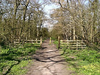
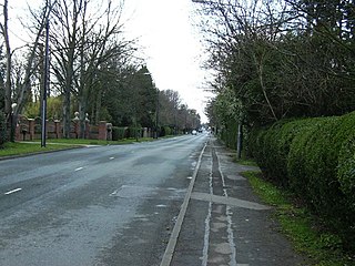
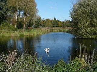
Bradley and Dixon Woods is a 41.77-hectare Local Nature Reserve near the town of Grimsby in North East Lincolnshire. It is owned and managed by North East Lincolnshire Council. It is composed of ancient woodland, meadows, ponds and bird feeding sites, and is located south-west of Grimsby and south of the village of Bradley; the site is bounded to the north by Woodlands Farm and Bradley Woodlands Independent Hospital. The LNR can be accessed by the public via the B1444 off the A46 road.
Lollycocks Field is a 2.15-hectare Local Nature Reserve in Sleaford, a market town and civil parish in the North Kesteven district of Lincolnshire. It is owned by North Kesteven District Council and managed jointly by Leisure Connection and rangers from Hill Holt Wood. Lollycocks Field provides mostly wildflower and wetlands habitats; its pond attracts range of wildlife. It is bounded to the north by Eastgate, to the east by the North Kesteven District Council offices and car park, and to the south by the River Slea. It is just east of Cogglesford Mill. The site can be accessed by the public from Eastgate, and car parks are located on East Road, further into the town and also off East Banks.
Mareham Pastures is an 11-hectare Local Nature Reserve in Sleaford, a market town and civil parish in the North Kesteven district of Lincolnshire. It is owned by Lincolnshire County Council and managed jointly by Lincolnshire County Council and the Friends of Mareham Pastures. The reserve consists of wildflower meadows, new woodland, hedges and open grassland, providing a good habitat for butterflies and potentially barn owls; it is located westwards off Mareham Lane and is bounded to the north and north-west by residential developments at Quarrington and by farmland to the south; it is adjacent to a disused recycling centre, situated to its east. The site can be accessed by the public on foot via Bullock Pastures Lane, which begins at Sleaford Cricket Ground off London Road; visitors travelling by car can park next to the former recycling centre off Mareham Lane and gain access that way.


