
Victoria is the capital city of the Canadian province of British Columbia, on the southern tip of Vancouver Island off Canada's Pacific coast. The city has a population of 91,867, and the Greater Victoria area has a population of 397,237. The city of Victoria is the seventh most densely populated city in Canada with 4,406 inhabitants per square kilometre (11,410/sq mi).

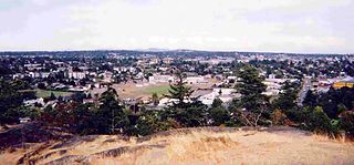
Saanich is a district municipality on Vancouver Island in British Columbia, within the Greater Victoria area. The population was 117,735 at the 2021 census, making it the most populous municipality in the Capital Regional District and Vancouver Island, and the eighth-most populous in the province. The district adopted its name after the Saanich First Nation, meaning "emerging land" or "emerging people". The district acts as a bedroom community immediately to the north of Victoria, British Columbia.
The Township of Esquimalt is a municipality at the southern tip of Vancouver Island, in British Columbia, Canada. It is bordered to the east by the provincial capital, Victoria, to the south by the Strait of Juan de Fuca, to the west by Esquimalt Harbour and Royal Roads, to the northwest by the New Songhees 1A Indian reserve and the town of View Royal, and to the north by a narrow inlet of water called the Gorge, across which is the district municipality of Saanich. It is almost tangential to Esquimalt 1 Indian Reserve near Admirals Road. It is one of the 13 municipalities of Greater Victoria and part of the Capital Regional District.

Greater Victoria is located in British Columbia, Canada, on the southern tip of Vancouver Island. It is usually defined as the thirteen municipalities of the Capital Regional District (CRD) on Vancouver Island as well as some adjacent areas and nearby islands.

Sidney is a town located at the northern end of the Saanich Peninsula, on Vancouver Island in the province of British Columbia. It is one of the thirteen Greater Victoria municipalities. It has a population of approximately 11,583. Sidney is located just east of Victoria International Airport, and about 6 km (4 mi) south of BC Ferries' Swartz Bay Terminal. The town is also the only Canadian port-of-call in the Washington State Ferries system, with ferries running from Sidney to the San Juan Islands and Anacortes. Sidney is located along Highway 17, which bisects the town from north to south. It is generally considered part of the Victoria metropolitan area.

Oak Bay is a municipality incorporated in 1906 that is located on the southern tip of Vancouver Island, in the Canadian province of British Columbia. It is one of thirteen member municipalities of the Capital Regional District, and is bordered to the west by the city of Victoria and to the north by the district of Saanich. It is an eastern residential suburb of Victoria.

Uplands, Victoria is a 188.17-hectare (465.0-acre) neighbourhood located in the north east part of the District of Oak Bay, a suburb adjacent to Victoria, British Columbia, Canada, and situated between the neighbourhoods of Cadboro Bay and North Oak Bay. Uplands is a prominent example of a garden suburb designed in the early part of the 20th century.
The District of North Saanich is located on the Saanich Peninsula of British Columbia, approximately 25 km (16 mi) north of Victoria on southern Vancouver Island. It is one of the 13 Greater Victoria municipalities. The district is surrounded on three sides by 20 km (12 mi) of ocean shoreline, and consists of rural/residential areas and a large agricultural base. It is home to the Victoria International Airport and the Swartz Bay Ferry Terminal.

Mount Douglas, usually referred to as Mount Doug by locals, is a prominent, 225 m (738 ft) hill in Saanich, British Columbia. It is located in (PKOLS) Mount Douglas Park in the municipality of Saanich.
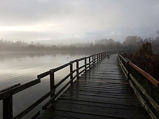
Swan Lake Christmas Hill Nature Sanctuary is a nature reserve located in Saanich, British Columbia. The sanctuary includes a lake, adjacent marshy lowlands, and the Nature House, as well as a good part of the summit regions of Christmas Hill.

Discovery Island is located off the eastern side of Vancouver Island and is viewable from Ten Mile Point, near Cadboro Bay, and Oak Bay. Discovery Island Marine Provincial Park occupies the southern portion of Discovery Island, 3 miles (4.8 km) east of Oak Bay. The northern portion of the island is part of Discovery Island Indian Reserve 3, under the control of the Songhees First Nation.

Gordon Head is a seaside neighbourhood in the municipality of Saanich in Greater Victoria, British Columbia, Canada. Gordon Head lies north of McKenzie Avenue and east of the Blenkinsop Valley. The University of Victoria is located partly within Gordon Head along the southeast boundary. Finnerty Road separates Gordon Head from the adjacent neighbourhood of Cadboro Bay. The local area is dominated physically by Mount Douglas, a coastline along Haro Strait, and the central plateau.

The Lekwungen or Lekungen nation are an Indigenous North American Coast Salish people who reside on southeastern Vancouver Island, British Columbia in the Greater Victoria area. Their government is the Songhees First Nation, a member of the Te'mexw Treaty Association and the Naut'sa Mawt Tribal Council. Their traditional language is Lekwungen, a dialect of the North Straits Salish language.

The Craigflower Manor and Craigflower Schoolhouse are National Historic Sites of Canada located in View Royal, British Columbia and Saanich near Victoria. The centerpiece of each historic site is a 19th-century building — a manor and schoolhouse commissioned by the Hudson's Bay Company to provide education and lodging for their employees. Built as part of the agricultural community Craigflower Farm, the buildings served as a focal point for the community into the modern era; they remain open to the public today as museums devoted to the colonial history of Victoria.

Victoria Harbour is a harbour, seaport, and seaplane airport in the Canadian city of Victoria, British Columbia. It serves as a cruise ship and ferry destination for tourists and visitors to the city and Vancouver Island. It is both a port of entry and an airport of entry for general aviation. Historically it was a shipbuilding and commercial fishing centre. While the Inner Harbour is fully within the City of Victoria, separating the city's downtown on its east side from the Victoria West neighbourhood, the Upper Harbour serves as the boundary between the City of Victoria and the district municipality of Esquimalt. The inner reaches are also bordered by the district of Saanich and the town of View Royal. Victoria is a federal "public harbour" as defined by Transport Canada. Several port facilities in the harbour are overseen and developed by the Greater Victoria Harbour Authority, however the harbour master's position is with Transport Canada.
Ten Mile Point is a neighbourhood in the District of Saanich in Victoria, British Columbia, and is the most easterly point on Vancouver Island. Ten Mile Point was so named because it was ten nautical miles from what was at the time the headquarters of the Pacific Station of the Royal Navy. Ten Mile Point is a wooded peninsula that forms one side of Cadboro Bay, the home of the Royal Victoria Yacht Club and the mythical Cadborosaurus sea monster. Cadboro Point is located on the east part of this peninsula. Prevost Hill was named after James Charles Prevost, British commissioner in the negotiations to settle the San Juan boundary dispute. Prevost Hill is the highest elevation on Ten Mile Point and is known informally in the neighbourhood as "Minnie Mountain". Prevost Hill is the location for a subdivision within Ten Mile Point called "Wedgewood Point" or "Wedgewood Estates". A small wooded island, "Flower Island", almost touches the southern shore of Ten Mile Point. Ten Mile Point has many secluded beaches and coves.
The 1862 Pacific Northwest smallpox epidemic was a smallpox outbreak that started in Victoria on Vancouver Island and spread among the indigenous peoples of the Pacific Northwest Coast and into the indigenous peoples of the Northwest Plateau, killing a large portion of natives from the Puget Sound region to Southeast Alaska. Two-thirds of British Columbia natives died—around 20,000 people. The death rate was highest in southeast Alaska and Haida Gwaii—over 70% among the Haida and 60% among the Tlingit. Almost all native nations along the coast, and many in the interior, were devastated, with a death rate of over 50% for the entire coast from Puget Sound to Sitka, Alaska, part of Russian America at the time. In some areas the native population fell by as much as 90%. The disease was controlled among colonists in 1862 but it continued to spread among natives through 1863.
The Dead Boats Disposal Society (DBDS) is a non-profit society dedicated to the removal and disposal of abandoned boats and marine debris from shorelines in British Columbia, Canada. The Victoria-based Society has hauled 124 boats out of the water since 2017, most from bays and inlets in the Capital Regional District from Sooke to the Gulf Islands. By February 2020, the group had removed 89,300 metric tonnes of marine debris.

The Esquimalt Lagoon Migratory Bird Sanctuary is a migratory bird sanctuary near Esquimalt Harbour in Colwood, British Columbia. The Esquimalt Lagoon is found on the traditional territories of the Esquimalt and Songhees Nations. The park was established in 1931 with the objective of creating a safe haven for migratory birds, and has become a popular place for birdwatching. Many other species can be found within the park, such as coho salmon and cutthroat trout. Pacific herring also spawn in nearby waters.

The Victoria Harbour Migratory Bird Sanctuary or VHMBS is a 30 km protected area on the southern tip of Vancouver Island, Canada, in the Greater Victoria metropolitan area. It is located within the traditional territory of the Lekwungen People. The sanctuary is federally recognized as a critical habitat for bird conservation, and is home to an estimated 270 bird species, many of which are migratory. The sanctuary encompasses about 30 kilometres of coastline, an area covering approximately 1841 hectares in total. Of this total, 31 hectares are terrestrial, and 1810 hectares are marine.
