Carmody Hills-Pepper Mill Village, Maryland

Last updated
Carmody Hills-Pepper Mill Village, Maryland
former Former CDP
Prince George's County Maryland Incorporated and Unincorporated areas Carmody Hills-Pepper Mill Village Highlighted.svg
Location of Carmody Hills-Pepper Mill Village, Maryland
Coordinates: 38°53′43″N76°53′24″W / 38.89528°N 76.89000°W / 38.89528; -76.89000
CountryFlag of the United States.svg  United States
State Flag of Maryland.svg  Maryland
County Flag of Prince George's County, Maryland (1963-present).svg Prince George's
Area
  Total0.7 sq mi (1.9 km2)
  Land0.7 sq mi (1.9 km2)
  Water0.0 sq mi (0.0 km2)
Population
 (2000)
  Total4,801
  Density6,501.9/sq mi (2,510.4/km2)
Time zone UTC−5 (Eastern (EST))
  Summer (DST) UTC−4 (EDT)
FIPS code 24-13312

Carmody Hills-Pepper Mill Village was a census-designated place (CDP) in Prince George's County, Maryland during the 2000 census. It consisted of two separate communities: Carmody Hills and Pepper Mill Village. For the 2010 census the area has been renamed as the Peppermill Village CDP.

Contents

Geography

Carmody Hills-Pepper Mill Village was located at 38°53′43″N76°53′24″W / 38.89528°N 76.89000°W / 38.89528; -76.89000 (38.895412, 76.890123). [1]

According to the United States Census Bureau, the place had a total area of 0.7 square miles (1.8 km2), all of it land.

Demographics

Historical population
CensusPop.Note
1970 6,245
1980 5,571−10.8%
1990 4,815−13.6%
2000 4,801−0.3%
source: [2]

As of the census [3] of 2000, there were 4,801 people, 1,578 households, and 1,256 families residing in the area. The population density was 6,501.9 inhabitants per square mile (2,510.4/km2). There were 1,686 housing units at an average density of 2,283.3 per square mile (881.6/km2). The racial makeup of the area was 1.46% White, 96.90% African American, 0.15% Native American, 0.15% Asian, 0.25% from other races, and 1.10% from two or more races. Hispanic or Latino of any race were 0.50% of the population.

There were 1,578 households, out of which 32.7% had children under the age of 18 living with them, 41.1% were married couples living together, 32.1% had a female householder with no husband present, and 20.4% were non-families. 16.9% of all households were made up of individuals, and 4.8% had someone living alone who was 65 years of age or older. The average household size was 3.03 and the average family size was 3.36.

In the area the population was spread out, with 29.4% under the age of 18, 7.6% from 18 to 24, 27.3% from 25 to 44, 25.5% from 45 to 64, and 10.2% who were 65 years of age or older. The median age was 35 years. For every 100 females, there were 88.0 males. For every 100 females age 18 and over, there were 81.2 males.

The median income for a household in the area was $49,068, and the median income for a family was $52,206. Males had a median income of $32,993 versus $35,357 for females. The per capita income for the area was $18,258. About 6.2% of families and 9.1% of the population were below the poverty line, including 15.2% of those under age 18 and 6.4% of those age 65 or over.

Related Research Articles

<span class="mw-page-title-main">Meridianville, Alabama</span> Census-designated place in Alabama, United States

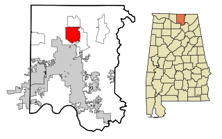
Meridianville is an unincorporated community and census-designated place (CDP) in Madison County, Alabama, United States, and is included in the Huntsville-Decatur Combined Statistical Area. As of the 2020 census, the population of the CDP was 8,209.

<span class="mw-page-title-main">Kongiganak, Alaska</span> CDP in Alaska, United States

Kongiganak is a census-designated place (CDP) in Bethel Census Area, Alaska, United States, and primarily sits on the eastern shore of the Kongiganak River. As of the 2010 census, the population was 439, up from 359 in 2000.

<span class="mw-page-title-main">Brunswick Station, Maine</span> Census-designated place in Maine, United States

Brunswick Station was a census-designated place (CDP) within the town of Brunswick in Cumberland County, Maine, United States. The population was 578 at the 2010 census. It consists of an area that was part of the former Naval Air Station Brunswick and was part of the Portland–South Portland–Biddeford, Maine Metropolitan Statistical Area. The 2020 census shows it as part of the Brunswick CDP.

<span class="mw-page-title-main">Hillsmere Shores, Maryland</span> Former census-designated place in Maryland, United States

Hillsmere Shores was a census-designated place (CDP) in Anne Arundel County, Maryland, United States. It is a suburb of Annapolis. The population was 2,977 at the 2000 census. It was included in the Annapolis Neck CDP at the 2010 census. Built in phases, beginning in 1960, the community has been home to The Key School, a non-sectarian private school, since the 1960s.

<span class="mw-page-title-main">Selby-on-the-Bay, Maryland</span> Former census-designated place in Maryland, United States

Selby-on-the-Bay is a census-designated place (CDP) in Anne Arundel County, Maryland, United States, for the 2000 census, at which time its population was 3,674. It was added to the Mayo CDP for the 2010 census.

<span class="mw-page-title-main">Kingsville, Maryland</span> Census-designated place in Maryland, United States

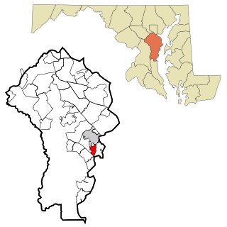
Kingsville is a semi-rural, unincorporated community and census-designated place in Baltimore County, Maryland, United States. It is a close-knit and rustic community bounded by the Little Gunpowder Falls river and the Big Gunpowder Falls river which join to form the Gunpowder River. The population of Kingsville was 4,318 at the 2010 census.

<span class="mw-page-title-main">Milford Mill, Maryland</span> Census-designated place in Maryland, United States

Milford Mill is an unincorporated community and census-designated place in Baltimore County, Maryland, United States. Per the 2020 census, the population was 30,622.

<span class="mw-page-title-main">Seat Pleasant, Maryland</span> City in Maryland

Seat Pleasant is an incorporated city in Prince George's County, Maryland, United States, located immediately east of Washington D.C.. Per the 2020 census, the population was 4,522. Two state highways pass through the community — Maryland routes 704 and 214. The Washington Metro's Blue and Silver Lines are nearby. The Washington Commanders' stadium is east of Seat Pleasant, near the Capital Beltway (I-95/495).

<span class="mw-page-title-main">Walker Mill, Maryland</span> Census-designated place in Maryland

Walker Mill is an unincorporated area and census-designated place (CDP) in Prince George's County, Maryland, United States. Per the 2020 census, the population was 12,187.

<span class="mw-page-title-main">El Rancho, New Mexico</span> Census-designated place in New Mexico, United States

El Rancho is a census-designated place (CDP) in Santa Fe County, New Mexico, United States. It is part of the Santa Fe, New Mexico Metropolitan Statistical Area. The population was 1,199 at the 2010 census.

<span class="mw-page-title-main">Village Green, New York</span> Census-designated place in New York, United States

Village Green is a hamlet in Onondaga County, New York, United States. The population was 3,891 at the 2010 census.

<span class="mw-page-title-main">Forest Home, New York</span> CDP in New York, United States

Forest Home is a census-designated place (CDP) in the town of Ithaca, New York, United States. The population was 572 at the 2010 census. It is located immediately east of the Cornell University campus.

Lower Allen is a census-designated place (CDP) in Lower Allen Township in Cumberland County, Pennsylvania, United States. The population was 6,694 at the 2010 census. It is part of the Harrisburg–Carlisle metropolitan statistical area.

<span class="mw-page-title-main">Branchdale, Pennsylvania</span> CDP in Pennsylvania, United States

Branchdale is a census-designated place (CDP) in Schuylkill County, Pennsylvania, United States. The population was 436 at the 2000 census.

<span class="mw-page-title-main">Marlin, Pennsylvania</span> CDP in Pennsylvania, United States

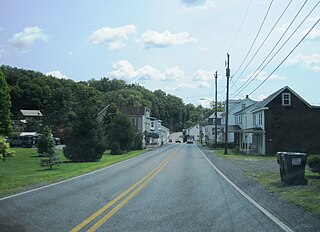
Marlin, or MarLin is a census-designated place (CDP) in Schuylkill County, Pennsylvania, United States. The population was 640 at the 2000 census. It is a village of Norwegian Township. The village is the seat of government for the township.

<span class="mw-page-title-main">Mount Carmel, South Carolina</span> CDP in South Carolina, United States

Mt. Carmel is a census-designated place (CDP) in McCormick County, South Carolina, United States. The population was 237 at the 2000 census.

<span class="mw-page-title-main">Prado Verde, Texas</span> Census-designated place in Texas, United States

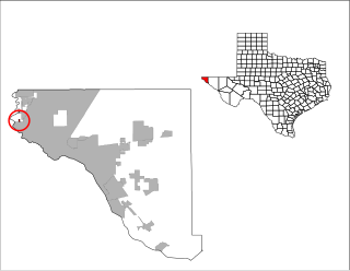
Prado Verde is a census-designated place (CDP) in El Paso County, Texas, United States. The population is 246 according to the 2010 census. It is part of the El Paso Metropolitan Statistical Area. The ZIP Code encompassing the CDP area is 79932.

<span class="mw-page-title-main">Wilder, Vermont</span> Census-designated place in Vermont, United States

Wilder is an unincorporated village and census-designated place (CDP) within the town of Hartford in Windsor County, Vermont, United States. It is the location of the Wilder Dam on the Connecticut River. The population of the CDP was 1,690 at the 2010 census. The village center is an early example of a planned mill community, and was listed on the National Register of Historic Places as the Wilder Village Historic District in 1999.

<span class="mw-page-title-main">Altona (CDP), New York</span> Census-designated place in New York, United States

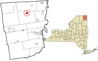
Altona is a hamlet and census-designated place (CDP) in the town of Altona, Clinton County, New York, United States. The population was 730 at the 2010 census, out of a total town population of 2,887.

Duncott is a census-designated place (CDP) in Schuylkill County, Pennsylvania, United States, near Minersville in the Coal Region. The population was 76 at the 2000 census. It is located in Cass Township.

References

  1. "US Gazetteer files: 2010, 2000, and 1990". United States Census Bureau. 2011-02-12. Retrieved 2011-04-23.
  2. "CENSUS OF POPULATION AND HOUSING (1790-2000)". U.S. Census Bureau . Retrieved 2010-07-18.
  3. "U.S. Census website". United States Census Bureau . Retrieved 2008-01-31.