Peppermill Village, Maryland

Last updated

Peppermill Village, Maryland
USA Maryland location map.svg
Red pog.svg
Peppermill Village, Maryland
Location within the U.S. state of Maryland
Usa edcp location map.svg
Red pog.svg
Peppermill Village, Maryland
Peppermill Village, Maryland (the United States)
Coordinates: 38°53′41″N76°53′12″W / 38.89472°N 76.88667°W / 38.89472; -76.88667
CountryFlag of the United States.svg  United States
StateFlag of Maryland.svg  Maryland
County Flag of Prince George's County, Maryland (1963-present).svg Prince George's
Area
[1]
  Total0.75 sq mi (1.94 km2)
  Land0.75 sq mi (1.94 km2)
  Water0.00 sq mi (0.00 km2)
Elevation
266 ft (81 m)
Population
 (2020)
  Total5,264
  Density7,028.04/sq mi (2,711.80/km2)
Time zone UTC−5 (Eastern (EST))
  Summer (DST) UTC−4 (EDT)
Area code 301, 240
FIPS code 24-60950
GNIS feature ID2391235

Peppermill Village is an unincorporated community near Maryland Route 214 (Central Avenue) in Prince George's County, Maryland, United States. [2] Per the 2020 census, the population was 5,264. [3] FedExField, Metrorail's Blue Line, and Hampton Mall shopping center are all located nearby. Because it is not formally incorporated, it has no official boundaries, but the United States Census Bureau has defined a census-designated place (CDP) consisting of Peppermill Village and the adjacent community of Carmody Hills, for statistical purposes.

Contents

Geography

According to the U.S. Census Bureau, Peppermill Village had a total area of 0.73 square miles (1.9 km2), all land. [4] The CDP is bordered to the west and north by the city of Seat Pleasant, to the north and east by the Summerfield CDP, and to the south by the Walker Mill CDP. Peppermill Village is bounded to the east by Hill Road, west by Carmody Hills Drive, north by Seat Pleasant Drive and south by Maryland Route 214, or Central Avenue, which to the west becomes East Capitol Street in the District of Columbia and to the east connects with the Capital Beltway and the town of Largo.

Demographics

Historical population
CensusPop.Note
2010 4,895
2020 5,2647.5%
U.S. Decennial Census [5]
2010 [6] 2020 [7]

2020 census

Peppermill Village CDP, Maryland – Racial and ethnic composition
Note: the US Census treats Hispanic/Latino as an ethnic category. This table excludes Latinos from the racial categories and assigns them to a separate category. Hispanics/Latinos may be of any race.
Race / Ethnicity (NH = Non-Hispanic)Pop 2010 [6] Pop 2020 [7] % 2010% 2020
White alone (NH)50861.02%1.63%
Black or African American alone (NH)4,4824,25491.56%80.81%
Native American or Alaska Native alone (NH)26140.53%0.27%
Asian alone (NH)13280.27%0.53%
Pacific Islander alone (NH)020.00%0.04%
Some Other Race alone (NH)3160.06%0.30%
Mixed Race or Multi-Racial (NH)641191.31%2.26%
Hispanic or Latino (any race)2577455.25%14.15%
Total4,8955,264100.00%100.00%

2010 Census

The population of the CDP was 4,895 at the 2010 census. [8] For previous censuses, the CDP was named "Carmody Hills-Pepper Mill Village".

It has a majority African-American population.

Schools

The CDP is served by the Prince George's County Public Schools district. [9]

Almost all of the CDP is zoned to Carmbody Hills elementary while a small section is zoned to Cora L. Rice Elementary. [10] All residents are zoned to G. James Gholson Middle School. [11] Most CDP residents are zoned to Central High School while some are zoned to Fairmont Heights High School and . [12]

Related Research Articles

<span class="mw-page-title-main">Camp Springs, Maryland</span> Census-designated place in Maryland

Camp Springs is an unincorporated area and census-designated place (CDP) in Prince George's County, Maryland, United States. The population was 22,734 at the 2020 census. Camp Springs is not an official post office designation; the area is divided among the surrounding mailing addresses of Temple Hills, Fort Washington, Clinton, and Suitland.

<span class="mw-page-title-main">Coral Hills, Maryland</span> Census-designated place in Maryland

Coral Hills is an unincorporated area and census-designated place (CDP) in Prince George's County, Maryland, United States. As of the 2020 census, the population was 9,997.

<span class="mw-page-title-main">Kettering, Maryland</span> Census-designated place in Maryland, United States

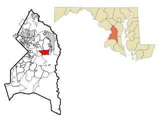
Kettering is an unincorporated area and census-designated place in Prince George's County, Maryland, United States. At the 2020 United States Census, the population was 14,424,. Kettering is adjacent to Prince George's Community College, the upscale gated community of Woodmore, Six Flags America, Evangel Temple megachurch, and the community of Largo at the end of the Washington Metro Blue Line. Watkins Regional Park in Kettering offers a large playground, a colorful carousel, miniature golf, a miniature train ride, and various animals.

<span class="mw-page-title-main">Temple Hills, Maryland</span> Census-designated place in Maryland, United States

Temple Hills is an unincorporated area and census-designated place (CDP) in Prince George's County, Maryland, United States. Temple Hills borders the communities of Hillcrest Heights, Marlow Heights, Camp Springs and Oxon Hill. Per the 2020 census, the population was 8,350.

<span class="mw-page-title-main">Walker Mill, Maryland</span> Census-designated place in Maryland

Walker Mill is an unincorporated area and census-designated place (CDP) in Prince George's County, Maryland, United States. Per the 2020 census, the population was 12,187.

Lanham is an unincorporated community and census-designated place in Prince George's County, Maryland. As of the 2020 United States Census it had a population of 11,282. The New Carrollton station as well as an Amtrak station are across the Capital Beltway in New Carrollton, Maryland. Doctors Community Hospital is located in Lanham.

Glassmanor is an unincorporated community and census-designated place in Prince George's County, Maryland, United States. As of the 2020 census, it had a population of 18,430. In the 1990 and 2000 censuses, the United States Census Bureau had placed Glassmanor and the adjacent community of Oxon Hill in the "Oxon Hill-Glassmanor" census-designated place for statistical purposes. Glassmanor was last delineated separately in 1980, when the CDP recorded a population of 7,751.

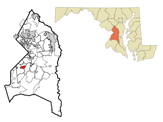
Silver Hill is an unincorporated community and census-designated place (CDP) in Prince George's County, Maryland, United States, approximately 1 mile (1.6 km) southeast of Washington, D.C. Per the 2020 census, the population was 6,381. Prior to 2010, Silver Hill was part of the Suitland-Silver Hill census-designated place.

Konterra is an unincorporated area and census-designated place (CDP) in Prince George's County, Maryland, United States. The population was 3,158 at the 2020 census.

<span class="mw-page-title-main">Aquasco, Maryland</span> Census-designated place in Maryland

Aquasco is an unincorporated area and census-designated place in southeastern Prince George's County, Maryland, United States, surrounding the town of Eagle Harbor and bordering Charles County. As of the 2020 census, the CDP had a population of 913. Aquasco was home to the Aquasco Speedway.

<span class="mw-page-title-main">Baden, Maryland</span> Census-designated place in Maryland, United States

Baden is an unincorporated area and census-designated place in southeastern Prince George's County, Maryland, United States. As of the 2020 census, the CDP had a population of 2,114.

<span class="mw-page-title-main">Brock Hall, Maryland</span> Census-designated place in Maryland

Brock Hall is an unincorporated area and census-designated place in eastern Prince George's County, Maryland, United States, located south of Largo and Bowie, and north of Upper Marlboro. As of the 2020 census, the CDP had a population of 13,181.

Cedarville is an unincorporated community and census-designated place in southern Prince George's County, Maryland, United States. As of the 2020 census the population was 639.

Fairwood is an unincorporated area and census-designated place (CDP) in Prince George's County, Maryland, United States. The population was 7,983 at the 2020 census.

<span class="mw-page-title-main">Marlboro Meadows, Maryland</span> Census-designated place in Maryland

Marlboro Meadows is an unincorporated community and census-designated place (CDP) in Prince George's County, Maryland, United States. Per the 2020 census, the population was 3,655. It was newly delineated for the 2010 census prior to which the area was part of the Greater Upper Marlboro census-designated place.

Marlboro Village is an unincorporated community and census-designated place (CDP) in Prince George's County, Maryland, United States. Per the 2020 census, the population was 9,221.

Melwood is an unincorporated community and census-designated place (CDP) in Prince George's County, Maryland, United States. It was newly delineated for the 2010 census, at which time its population was 3,051. Per the 2020 census, the population was 3,977.

Queensland is a census-designated place south of Upper Marlboro in Prince George's County, Maryland, United States. The population of the CDP was 2,191 at the 2020 census. It was formerly known as Queenland until 2014 when its name was changed to Queensland and a small portion of its geography was transferred to Upper Marlboro.

Summerfield is a census-designated place near Landover in Prince George's County, Maryland. As of the 2020 census, the population was 14,758. It is a suburb of Washington, D.C.

Westphalia is a census-designated place in southern Prince George's County, Maryland, United States. The population of the CDP was 11,770 at the 2020 census.

References

  1. "2020 U.S. Gazetteer Files". United States Census Bureau. Retrieved April 26, 2022.
  2. U.S. Geological Survey Geographic Names Information System: Peppermill Village, Maryland
  3. "Peppermill Village CDP, Maryland". United States Census Bureau . Retrieved April 15, 2022.
  4. "Geographic Identifiers: 2010 Demographic Profile Data (G001): Peppermill Village CDP, Maryland". United States Census Bureau . Retrieved December 16, 2011.
  5. "Decennial Census of Population and Housing by Decades". US Census Bureau.
  6. 1 2 "P2 Hispanic or Latino, and Not Hispanic or Latino by Race – 2010: DEC Redistricting Data (PL 94-171) – Peppermill Village CDP, Maryland". United States Census Bureau .
  7. 1 2 "P2 Hispanic or Latino, and Not Hispanic or Latino by Race – 2020: DEC Redistricting Data (PL 94-171) – Peppermill Village CDP, Maryland". United States Census Bureau .
  8. "Profile of General Population and Housing Characteristics: 2010 Demographic Profile Data (DP-1): Peppermill Village CDP, Maryland". United States Census Bureau . Retrieved December 16, 2011.
  9. "2010 CENSUS - CENSUS BLOCK MAP: Peppermill Village CDP, MD." U.S. Census Bureau. Retrieved on August 31, 2018.
  10. "NEIGHBORHOOD ELEMENTARY SCHOOLS AND BOUNDARIES SCHOOL YEAR 2018-2019." Prince George's County Public Schools. Retrieved on August 31, 2018.
  11. "NEIGHBORHOOD MIDDLE SCHOOLS AND BOUNDARIES SCHOOL YEAR 2018-2019." Prince George's County Public Schools. Retrieved on August 31, 2018.
  12. "NEIGHBORHOOD HIGH SCHOOLS AND BOUNDARIES SCHOOL YEAR 2018-2019." Prince George's County Public Schools. Retrieved on August 31, 2018.