Cascade-Sierra province

Last updated

Cascade Range
Mount Shuksan tarn.jpg
Highest point
PeakMount Rainier
Elevation 14,411 ft (4,392 m)
Dimensions
Length700 mi (1,100 km)
Geography
CountriesUnited States and Canada
States British Columbia, Washington, Oregon, and California
Sierra Nevada
Mount Whitney September 2009.JPG
Highest point
Peak Mount Whitney
Elevation 14,505 ft (4,421 m)
Dimensions
Length400 mi (640 km)north-south from Fredonyer Pass to Tehachapi Pass
Width65 mi (105 km)
Geography
CountryUnited States
StatesCalifornia and Nevada

The Cascade-Sierra province is a physiographic region of mountains in the western United States, east and adjacent to Pacific Border province and west and adjacent to the Basin and Range Province (in the south) and Columbia Plateau Province (in the north).

Contents

About the region

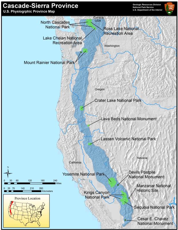
The Cascade-Sierra province stretches approximately 1,000 mi (1,609.34 km) from the high desert region of the Mojave Desert in Southern California to just north of the border between British Columbia and the state of Washington. [1] [2]

The region is extremely diverse geologically and ecologically and is commonly divided into two regions: the Cascade Mountains and the Sierra Nevada Mountains. This province is part of a larger physiographic region that extends from Alaska in the north to the southern tip of South America. Several tectonic plates meet and form this region and make it one of the most geologically active places in North America. [3]

The province is home to several national forests, including the Lassen, Modoc, and Plumas National Forests. The Modoc Plateau, an area of high elevation basalt flows between the Medicine Lake Highlands and the Warner Mountains, is also within the region. The ecology of the province is extremely diverse and contains areas of pine, aspen, and cypress forests, mixed conifer and evergreen forests, along with montane meadows, fens, mammoth granite outcroppings, vernal pools, and sagebrush flats. [4]

Cascade Mountain Range

The Cascade Mountains form the northern portion of the Cascade-Sierra province. The Cascades were created from thousands of small, short-lived volcanoes along the Cascadia subduction zone [5] that over millions of years built a foundation of lava and volcanic debris on which the mountains rise. This range includes thirteen major volcanic centers and are part of the Pacific Ocean's Ring of Fire. The two most recent eruptions are the Mount Lassen eruptions from 1914 to 1921, [6] and the Mount St. Helens eruption in 1980. [7]

Sierra Nevada Mountain Range

The Sierra Nevada Mountains form the southern portion of the Cascade-Sierra province. Like the Cascade Range, the Sierra Nevada Range formed from a chain of volcanoes along a subduction zone. However unlike the Cascade volcanoes, those that formed the Sierra Nevada Range are mostly extinct and buried deep within the earth forming a bed of solidified lava that is responsible for the gray granitic rocks of the Sierra. One of the best known areas in the Sierra Nevada range is Yosemite National Park. [3] [4]

Further reading

See also

Related Research Articles

<span class="mw-page-title-main">Geography of California</span>

California is a U.S. state on the western coast of North America. Covering an area of 163,696 sq mi (423,970 km2), California is among the most geographically diverse states. The Sierra Nevada, the fertile farmlands of the Central Valley, and the arid Mojave Desert of the south are some of the major geographic features of this U.S. state. It is home to some of the world's most exceptional trees: the tallest, most massive, and oldest. It is also home to both the highest and lowest points in the 48 contiguous states. The state is generally divided into Northern and Southern California, although the boundary between the two is not well defined. San Francisco is decidedly a Northern California city and Los Angeles likewise a Southern California one, but areas in between do not often share their confidence in geographic identity. The US Geological Survey defines the geographic center of the state at a point near North Fork, California.

<span class="mw-page-title-main">Cascade Range</span> Mountain range in western North America

The Cascade Range or Cascades is a major mountain range of western North America, extending from southern British Columbia through Washington and Oregon to Northern California. It includes both non-volcanic mountains, such as many of those in the North Cascades, and the notable volcanoes known as the High Cascades. The small part of the range in British Columbia is referred to as the Canadian Cascades or, locally, as the Cascade Mountains. The highest peak in the range is Mount Rainier in Washington at 14,411 feet (4,392 m).

<span class="mw-page-title-main">Ring of Fire</span> Region around the rim of the Pacific Ocean where many volcanic eruptions and earthquakes occur

The Ring of Fire is a tectonic belt of volcanoes and earthquakes, about 40,000 km (25,000 mi) long and up to about 500 km (310 mi) wide, which surrounds most of the Pacific Ocean. The exact number of volcanoes within the Ring of Fire is not universally agreed but, depending on which regions are included in any particular count, it contains between 750 and 915 active or dormant volcanoes, around two-thirds of the world total. About 90% of the world's earthquakes, including most of its largest, occur within the belt.

<span class="mw-page-title-main">Pacific Coast Ranges</span> Series of mountain ranges along the Pacific coast of North America

The Pacific Coast Ranges are the series of mountain ranges that stretch along the West Coast of North America from Alaska south to Northern and Central Mexico. Although they are commonly thought to be the westernmost mountain range of the continental United States and Canada, the geologically distinct Insular Mountains of Vancouver Island lie farther west.

<span class="mw-page-title-main">Basin and Range Province</span> Physiographic region extending through western United States and Mexico

The Basin and Range Province is a vast physiographic region covering much of the inland Western United States and northwestern Mexico. It is defined by unique basin and range topography, characterized by abrupt changes in elevation, alternating between narrow faulted mountain chains and flat arid valleys or basins. The physiography of the province is the result of tectonic extension that began around 17 million years ago in the early Miocene epoch.

<span class="mw-page-title-main">Lava Beds National Monument</span> National monument in California, United States

Lava Beds National Monument is located in northeastern California, in Siskiyou and Modoc counties. The monument lies on the northeastern flank of Medicine Lake Volcano, which is the largest volcano by area in the Cascade Range.

<span class="mw-page-title-main">Lassen Volcanic National Park</span> National park in California, United States

Lassen Volcanic National Park is an American national park in northeastern California. The dominant feature of the park is Lassen Peak, the largest plug dome volcano in the world and the southernmost volcano in the Cascade Range. Lassen Volcanic National Park is one of the few areas in the world where all four types of volcano can be found—plug dome, shield, cinder cone, and stratovolcano.

<span class="mw-page-title-main">Geology of the Lassen volcanic area</span> Geology of a U.S. national park in California

The Lassen volcanic area presents a geological record of sedimentation and volcanic activity in and around Lassen Volcanic National Park in Northern California, U.S. The park is located in the southernmost part of the Cascade Mountain Range in the Pacific Northwest region of the United States. Pacific Oceanic tectonic plates have plunged below the North American Plate in this part of North America for hundreds of millions of years. Heat and molten rock from these subducting plates has fed scores of volcanoes in California, Oregon, Washington and British Columbia over at least the past 30 million years, including these in the Lassen volcanic areas.

<span class="mw-page-title-main">Lassen Peak</span> Active volcano in California, United States

Lassen Peak, commonly referred to as Mount Lassen, is a lava dome volcano and the southernmost active volcano in the Cascade Range of the Western United States. Located in the Shasta Cascade region of Northern California, it is part of the Cascade Volcanic Arc, which stretches from southwestern British Columbia to northern California. Lassen Peak reaches an elevation of 10,457 ft (3,187 m), standing above the northern Sacramento Valley. It supports many flora and fauna among its diverse habitats, which are subject to frequent snowfall and reach high elevations.

<span class="mw-page-title-main">Chaos Crags</span> Mountain in the Cascade range in California

Chaos Crags is the youngest group of lava domes in Lassen Volcanic National Park, California. They formed as six dacite domes 1,100-1,000 years ago, one dome collapsing during an explosive eruption about 70 years later. The eruptions at the Chaos Crags mark one of just three instances of Holocene activity within the Lassen volcanic center. The cluster of domes is located north of Lassen Peak and form part of the southernmost segment of the Cascade Range in Northern California. Each year, a lake forms at the base of the Crags, and typically dries by the end of the summer season.

<span class="mw-page-title-main">Shasta Cascade</span> Mountainous region of California

The Shasta Cascade region of California is located in the northeastern and north-central sections of the state bordering Oregon and Nevada, including far northern parts of the Central Valley and the Sierra Nevada mountain range.

<span class="mw-page-title-main">Geology of the United States</span> National geology

The richly textured landscape of the United States is a product of the dueling forces of plate tectonics, weathering and erosion. Over the 4.5 billion-year history of the Earth, tectonic upheavals and colliding plates have raised great mountain ranges while the forces of erosion and weathering worked to tear them down. Even after many millions of years, records of Earth's great upheavals remain imprinted as textural variations and surface patterns that define distinctive landscapes or provinces.

<span class="mw-page-title-main">Mount Tehama</span> Eroded Andesitic stratovolcano in Northern California

Mount Tehama is an eroded andesitic stratovolcano in the Cascade Volcanic Arc and the Cascade Range in Northern California. Part of the Lassen volcanic area, its tallest remnant, Brokeoff Mountain, is itself the second highest peak in Lassen Volcanic National Park and connects to the park's highest point, Lassen Peak. Located on the border of Tehama County and Shasta County, Brokeoff's peak is the highest point in the former. The hikers that summit this mountain each year are treated to "exceptional" views of Lassen Peak, the Central Valley of California, and many of the park's other features. On clear days, Mount Shasta can also be seen in the distance.

<span class="mw-page-title-main">Lassen National Forest</span> United States national forest

Lassen National Forest is a United States national forest of 1,700 square miles (4,300 km2) in northeastern California. It is named after pioneer Peter Lassen, who mined, ranched and promoted the area to emigrant parties in the 1850s.

<span class="mw-page-title-main">Pacific Ranges</span> Subrange of the Coast Mountains in British Columbia, Canada

The Pacific Ranges are the southernmost subdivision of the Coast Mountains portion of the Pacific Cordillera. Located entirely within British Columbia, Canada, they run northwest from the lower stretches of the Fraser River to Bella Coola and Burke Channel, north of which are the Kitimat Ranges. The Coast Mountains lie between the Interior Plateau and the Coast of British Columbia.

<span class="mw-page-title-main">North American Cordillera</span> North American portion of the American Cordillera mountain chain

The North American Cordillera, sometimes also called the Western Cordillera of North America, the Western Cordillera or the Pacific Cordillera, is the North American portion of the American Cordillera, the mountain chain system (cordillera) along the western coast of the Americas. The North American Cordillera covers an extensive area of mountain ranges, intermontane basins and plateaus in Western/Northwestern Canada, Western United States and Mexico, including much of the territory west of the Great Plains.

<span class="mw-page-title-main">Cascade Volcanoes</span> Chain of stratovolcanoes in western North America

The Cascade Volcanoes are a number of volcanoes in a volcanic arc in western North America, extending from southwestern British Columbia through Washington and Oregon to Northern California, a distance of well over 700 miles (1,100 km). The arc formed due to subduction along the Cascadia subduction zone. Although taking its name from the Cascade Range, this term is a geologic grouping rather than a geographic one, and the Cascade Volcanoes extend north into the Coast Mountains, past the Fraser River which is the northward limit of the Cascade Range proper.

<span class="mw-page-title-main">Geology of the Pacific Northwest</span> Geology of Oregon and Washington (United States) and British Columbia (Canada)

The geology of the Pacific Northwest includes the composition, structure, physical properties and the processes that shape the Pacific Northwest region of North America. The region is part of the Ring of Fire: the subduction of the Pacific and Farallon Plates under the North American Plate is responsible for many of the area's scenic features as well as some of its hazards, such as volcanoes, earthquakes, and landslides.

<span class="mw-page-title-main">Outline of California</span> Overview of and topical guide to California

The following outline is provided as an overview of and topical guide to the U.S. state of California.

<span class="mw-page-title-main">California Volcano Observatory</span> Research center in California, United States

The California Volcano Observatory (CalVO) is the volcano observatory that monitors the volcanic and geologic activity of California and Nevada. It is a part of the Volcano Hazards Program of the United States Geological Survey, a scientific agency of the United States government.

References

  1. Fenneman, Nevin. (1928). Physiographic Divisions of the United States. Annals of the Association of American Geographers, 18(4), 261-353. Retrieved August 17, 2020.
  2. "Map of the Cascade-Sierra province". United States National Park Service. Retrieved August 16, 2020.
  3. 1 2 "Cascade-Sierra Mountains Province". U.S. National Park Service. Retrieved August 16, 2020.
  4. 1 2 "Region 5 - Plants & Animals". United States Department of AgricultureForest Service. Retrieved August 16, 2020.
  5. "Cascadia Subduction Zone". The Pacific Northwest Seismic Network. Retrieved August 16, 2020.
  6. "The Eruption of Lassen Peak - Lassen Volcanic National Park ()". U.S. National Park Service. Retrieved August 16, 2020.
  7. Tilling, Robert (1982). "Eruptions of Mount St Helens Past Present and Future". Washington D.C.: U.S. Geological Survey. doi:10.3133/7000008.