General information | |
---|---|
Location | Church Stretton, Shropshire England |
Grid reference | SO455935 |
Managed by | Transport for Wales |
Platforms | 2 |
Other information | |
Station code | CTT |
Classification | DfT category F1 |
Key dates | |
1852 | Opened |
1914 | Station moved |
Passengers | |
2018/19 | 0.124 million |
2019/20 | 0.127 million |
2020/21 | 45,818 |
2021/22 | 0.114 million |
2022/23 | 0.111 million |
Notes | |
Passenger statistics from the Office of Rail and Road |
Church Stretton railway station is a railway station serving the town of Church Stretton in Shropshire,England on the Welsh Marches Line,12+3⁄4 miles (20.5 km) south of Shrewsbury railway station; trains on the Heart of Wales Line also serve the station. All trains services are operated by Transport for Wales, who also manage the station.
The station is the highest point of the line between Shrewsbury and Craven Arms, and is the highest station in Shropshire. On the northbound platform, a small plinth notes the station's altitude: 613 ft (187 m) above sea level.
The station opened on 20 April 1852 as part of the newly created Shrewsbury and Hereford Railway. It was originally to the north of what is now Sandford Avenue and the old station building still remains, but is no longer in railway use. Sandford Avenue had been for centuries called Lake Lane and became Station Road with the arrival of the railway in the town, before becoming Sandford Avenue in 1884. [1] The original station building was designed by Thomas Mainwaring Penson. [2]
In 1914, the station was relocated just to the south of the Sandford Avenue road bridge. New station buildings were erected, but these were demolished in 1970, the station having become unstaffed in 1967. Today, the only station structures in use are two passenger shelters on the platforms and a footbridge. [1]
The station has two platforms, one for northbound services (platform 1), and the other for southbound services (platform 2), with a footbridge crossing the line connecting the two platforms. The platform shelters were replaced and electronic information displays were installed in 2011. CCTV was also installed, and together with the new shelters has resulted in anti-social behaviour becoming almost non-existent at the station. [3] In 2013, a ticket machine was installed on platform 1.
There are two small areas for car parking/dropping off on either side of the line – one can be accessed from Sandford Avenue (the B4371), the other from Crossways, off the A49.
The station has been adopted by local volunteers and is kept tidy by them, including the garden areas behind both platforms. [4] In 2008, a group of volunteers transformed the unattended station gardens and two years later won the Station Gardens of the Year competition. In 2011, a tree sculpture depicting two owls was carved by David Bytheway. [5] There is also a Church Stretton Rail Users' Association. [3] The main passenger footbridge connecting the two platforms was renovated and painted in 2013.
For a town of its size, Church Stretton is comparatively well served by trains, although services are less frequent on Sundays. A number of passenger services operating on the Welsh Marches Line do not stop at Church Stretton, particularly on weekdays. [6]
On weekdays, northbound trains run to Shrewsbury, and most continue to ultimate destinations such as Manchester Piccadilly and Holyhead. Southbound trains mostly run to Cardiff Central or beyond via the Welsh Marches Line, but four run to Swansea via the Heart of Wales Line.
The station has a large number of passengers using it considering the town has a population of just 5,000 and is the eighth most-used station in Shropshire. [7] The high usage can be explained by two reasons: the town is a popular tourist destination and many of its inhabitants travel to Shrewsbury and Ludlow for employment, education and shopping.
The track through the station is prone to flooding when heavy rain occurs as, although at the apex of the line, it is at the bottom of the valley in which Church Stretton lies and is effectively a saddle point. In the wet autumn of 2000, the space between the two platforms filled with water and train services had to be cancelled along the line.
Following serious flooding of the railway in 2000, the signal box at Church Stretton, to the north of the Sandford Avenue bridge, was "switched out" and closed in 2004. The set of points at the station lay defunct before being removed in 2009, together with the box (built 1872) and all signals. [1] Control of the line has been transferred to Marsh Brook signal box to the south. [8]
Church Stretton is served by the 435 Shrewsbury-Ludlow bus, operated by Minsterley Motors, which runs Monday-Saturday. [9] This connects the town with nearby villages including All Stretton, Dorrington, Leebotwood, Little Stretton and Marshbrook. In addition, there are two Shropshire Hills Shuttles services that operate at weekends and on Bank Holidays in the spring and summer. One route runs over the Long Mynd to Ratlinghope and Bridges, Stiperstones, Habberley, Pulverbatch, Minsterley and Pontesbury. The other route, called the "Wenlock Wanderer", runs to Much Wenlock via Little Stretton, Marshbrook, Acton Scott, Ticklerton and then along the B4371 which runs atop the Wenlock Edge to the market town of Much Wenlock. [10] Bus services run to and from Beaumont Road, 300 yards (270 m) from the station (grid reference SO454937 ).
Church Stretton is a market town and civil parish in Shropshire, England, 13 miles (21 km) south of Shrewsbury and 15 miles (24 km) north of Ludlow. The population in 2011 was 4,671.
The A49 is an A road in western England, which traverses the Welsh Marches region. It runs north from Ross-on-Wye in Herefordshire via Hereford, Leominster, Ludlow, Shrewsbury and Whitchurch, then continues through central Cheshire to Warrington and Wigan before terminating at its junction with the A6 road just south of Bamber Bridge, near the junction of the M6, M65 and M61 motorways.
Much Wenlock is a market town and parish in Shropshire, England, situated on the A458 road between Shrewsbury and Bridgnorth. Nearby, to the northeast, is the Ironbridge Gorge and Telford. The civil parish includes the villages of Homer, Wyke, Atterley, Stretton Westwood and Bourton. The population of the civil parish, according to the 2001 census, was 2,605, increasing to 2,877 at the 2011 Census.
Wenlock Edge is a limestone escarpment near Much Wenlock, Shropshire, England and a site of special scientific interest because of its geology. It is over 19 mi (31 km) long, running southwest to northeast between Craven Arms and Much Wenlock, and is roughly 1,083 feet above sea level. The deciduous woodland which runs along it covers much of the steep slopes of the escarpment and in parts it is very well preserved.
The English county of Shropshire has a fairly large railway network, with 19 National Rail stations on various national lines; there are also a small number of heritage and freight lines, including the famous heritage Severn Valley Railway running along its eastern border with Worcestershire.
The Welsh Marches line, known historically as the North and West Route, is the railway line running from Newport in south-east Wales to Shrewsbury in the West Midlands region of England by way of Abergavenny, Hereford and Craven Arms and thence to Crewe via Whitchurch. The line thus links the south of Wales to north-west England via the Welsh Marches region, bypassing Birmingham. Through services from south-west Wales, Swansea and Cardiff to Manchester and from Cardiff to Wrexham, Chester, the north coast of Wales and Anglesey constitute the bulk of passenger operations on the route.
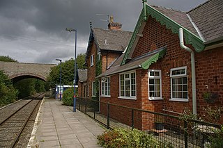
Ludlow railway station in Ludlow, Shropshire, England, lies on the Welsh Marches Line between Shrewsbury 27 miles 42 chains (44.3 km) to the north and Hereford. The station is on Station Drive, 1⁄2 mile (0.80 km) to the northeast of Ludlow town centre.
Shrewsbury railway station is in Shrewsbury, Shropshire, England. Built in 1848, it was designated a grade II listed building in 1969.
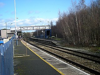
Craven Arms railway station serves the town of Craven Arms in Shropshire, England. Until 1974 it was known as "Craven Arms and Stokesay", named after the nearby coaching inn and the historic settlement of Stokesay to the south. It is situated at the junction of the Welsh Marches Line and the Heart of Wales Line, 20 miles (32 km) south of Shrewsbury. All passenger trains calling at the station are operated by Transport for Wales, who also manage it.
Gobowen railway station is a railway station on the Shrewsbury to Chester Line of the former Great Western Railway's London Paddington to Birkenhead Woodside via Birmingham Snow Hill line, serving the village of Gobowen in Shropshire, England. It is the nearest station to the town of Oswestry.
Leominster railway station lies on the Welsh Marches Line serving the Herefordshire town of Leominster in England. It is situated 11+1⁄4 miles (18.1 km) north of Hereford.
Hopton Heath railway station in Hopton Heath, Shropshire, England, lies on the Heart of Wales Line, 25+1⁄2 miles (41.0 km) south west of Shrewsbury.
Bucknell railway station serves the village of Bucknell in Shropshire, England 28+1⁄4 miles (45.5 km) south west of Shrewsbury on the Heart of Wales Line.
Chirk railway station serves the town of Chirk, Wrexham County Borough, Wales. The station is on the Shrewsbury to Chester Line 21 miles (34 km) north of Shrewsbury, which is part of the former Great Western Railway mainline route from London Paddington to Birkenhead Woodside. The original 19th-century Chirk / Y Waun station building was demolished in 1987, without consultation, by the local council.
Telford Central railway station serves the town of Telford, Shropshire, England. It is located on the Wolverhampton to Shrewsbury Line 15+1⁄2 miles (24.9 km) north west of Wolverhampton and is operated by West Midlands Trains. It is situated close to the Telford Shopping Centre, the main commercial district of the town.
Wem railway station serves the town of Wem in Shropshire, England. The station is 10¾ miles (17 km) north of Shrewsbury on the Welsh Marches Line to Crewe.
Whitchurch (Shropshire) railway station serves the town of Whitchurch in Shropshire, England. The station is 18¾ miles (30 km) north of Shrewsbury on the Welsh Marches Line. The station is maintained and served by Transport for Wales.
National Cycle Network Route 44, part of the National Cycle Network, connects Shrewsbury, Shropshire with Cinderford, Gloucestershire. The part of the route from Shrewsbury to Bromfield is signed - the remainder of the route is currently unsigned.
Preceding station | National Rail | Following station | ||
---|---|---|---|---|
Craven Arms | Transport for Wales Welsh Marches Line | Shrewsbury | ||
Transport for Wales Heart of Wales Line | ||||
Historical railways | ||||
Little Stretton Halt Line open, station closed | Shrewsbury and Hereford Railway | All Stretton Halt Line open, station closed |