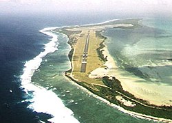
The Cocos (Keeling) Islands, officially the Territory of Cocos (Keeling) Islands, are an Australian external territory in the Indian Ocean, comprising a small archipelago approximately midway between Australia and Sri Lanka and relatively close to the Indonesian island of Sumatra. The territory's dual name reflects that the islands have historically been known as either the Cocos Islands or the Keeling Islands.
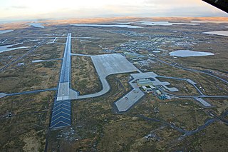
RAF Mount Pleasant is a Royal Air Force station in the British Overseas Territory of the Falkland Islands. The airfield goes by the motto of "Defend the right" and is part of the British Forces South Atlantic Islands (BFSAI). Home to between 1,000 and 2,000 British military personnel, it is about 33 miles (53 km) southwest of Stanley, the capital of the Falklands—on the island of East Falkland. The world's longest corridor, 2,600 feet (800 m) long, links the barracks, messes, and recreational and welfare areas of the station, and was nicknamed the "Death Star Corridor" by personnel.

London Biggin Hill Airport is the main international airport serving Biggin Hill in the London Borough of Bromley, located 12 NM south-southeast of Central London. The airport was formerly a Royal Air Force station RAF Biggin Hill, and a small enclave on the airport still retains that designation.

Operations Black Buck 1 to Black Buck 7 were seven extremely long-range ground attack missions conducted during the 1982 Falklands War by Royal Air Force (RAF) Vulcan bombers of the RAF Waddington Wing, comprising aircraft from Nos. 44, 50 and 101 Squadrons, against Argentine positions in the Falkland Islands. Five of the missions completed attacks. The objective of the missions was to attack Port Stanley Airport and its associated defences. The raids, at almost 6,600 nautical miles and 16 hours for the round trip, were the longest-ranged bombing raids in history at that time.

Royal Air Force Fairford or more simply RAF Fairford is a Royal Air Force (RAF) station in Gloucestershire, United Kingdom. While being an RAF station, Fairford hosts United States Air Force personnel. Since 2019, the base has played host to a Lockheed U-2S Dragon Lady detachment from the 99th Expeditionary Reconnaissance Squadron. It is the USAF's only European airfield for heavy bombers and routinely supports Bomber Task Force (BTF) operations. Its most prominent use in recent years has been as an airfield for United States Air Force B-52s during the 2003 Iraq War, Operation Allied Force in 1999, and the first Gulf War in 1991.

The Royal Netherlands Air Force is the military aviation branch of the Netherlands Armed Forces. It was created in 1953 to succeed its predecessor, the Luchtvaartafdeling of the Dutch Army, which was founded in 1913. The aerobatic display team of the Royal Netherlands Air Force, active from 1979 until 2019, was the Solo Display Team.
The history of the Royal Air Force, the air force of the United Kingdom, spans a century of British military aviation.
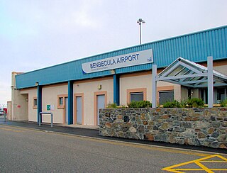
Benbecula Airport is located on the island of Benbecula in the Outer Hebrides, off the West Coast of Scotland. It is a small rural airport owned and maintained by Highlands and Islands Airports Limited.

RAAF Base Tindal is a Royal Australian Air Force (RAAF) military air base and civil aviation airfield located 8 nautical miles east southeast of the town of Katherine, Northern Territory in Australia. The base is currently home to No. 75 Squadron and a number of non-flying units, and also hosts the civilian Katherine Tindal Airport. First constructed in 1942, it was refurbished in the late 1960s as a bare base capable of being utilised when required. It was opened as a permanently manned RAAF base in 1989.

RAAF Base Townsville is a Royal Australian Air Force (RAAF) air base located in Garbutt, 2 nautical miles west of Townsville in Queensland, Australia. It is the headquarters for No. 1 Wing Australian Air Force Cadets and, along with Lavarack Barracks, establishes Townsville as a key military centre. The base's airfield is shared with the Townsville Airport.
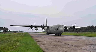
RMAF Butterworth is an active Air Force Station of the Royal Malaysian Air Force (RMAF) situated 4.5 nautical miles from Butterworth in Penang, Malaysia. It is currently home to the Headquarters Integrated Area Defence System (HQIADS), part of the Five Power Defence Arrangements (FPDA).

Mungalalu Truscott Airbase or Truscott-Mungalalu Airport, which during World War II was known as Truscott Airfield is today a commercial airport in the remote Kimberley region of Western Australia.

Camden Airport is an aerodrome located on the outskirts of Sydney, 1 nautical mile northwest of Camden, New South Wales, Australia. The airport is located approximately 60 km (37 mi) from Sydney's central business district. Camden is used as a general aviation overflow airport for the busier Bankstown Airport, and provides facilities for gliding and ballooning. The aerodrome has one grass runway and one paved runway and two glider airstrips. It is in the south-west corner of the designated Sydney flight training area.

Christmas Island International Airport is an airport located on Christmas Island, a territory of Australia in the Indian Ocean. The island is located 2,600 km (1,600 mi) northwest of the Western Australian city of Perth, 500 km (310 mi) south of the Indonesian capital, Jakarta, and 975 km (606 mi) east-northeast of the Cocos (Keeling) Islands.

Faleolo International Airport is an airport located 40 kilometres (25 mi) west of Apia, the capital of Samoa. Until 1984, Faleolo could not accommodate jets larger than a Boeing 737. Services to the United States, Australia, or New Zealand, could only land at Pago Pago International Airport in American Samoa. Since the airport's expansion, most international traffic now uses Faleolo.
Car Nicobar Air Force Base is located in IAF Camp village, on Car Nicobar Island in the Union territory of the Andaman and Nicobar Islands, India.

No. 217 Squadron RAF was a squadron of the RAF. It was formed and disbanded four times between 1 April 1918 and 13 November 1959. In World War I it served in a strike role against enemy bases and airfields in Belgium. In World War II as part of RAF Coastal Command it served first in a maritime patrol role along the Western Approaches and later in an anti-shipping role in the English Channel. Ordered to the Far East in 1942, the squadron was retained for two months in Malta in an anti-shipping role, protecting Allied convoys, before moving to Ceylon to defend the approaches to India, serving in an anti-submarine and anti-shipping role. It was equipped and training for a strike role, when the war ended. In the postwar period, it served for five years in a maritime reconnaissance role, and then briefly in a support role for Operation Grapple, the British hydrogen bomb tests on Christmas Island.

Dishforth Airfield is a former Royal Air Force and current British Army station in North Yorkshire, England. It was previously an Army Air Corps helicopter base and a Relief Landing Ground for RAF Linton-on-Ouse. 6 Regiment RLC is currently located at Dishforth. It is located next to the A1(M) at Junction 49 with the A168. Dishforth airfield is built over part of the Great North Road which is also the old A1. It is 4.4 miles (7.1 km) east of Ripon, North Yorkshire and 11.5 miles (18.5 km) north east of Harrogate, North Yorkshire, England.
The Qantas Huts are heritage-listed former accommodation huts at Sydney Highway, West Island, Cocos (Keeling) Islands, Australia. They were added to the Australian Commonwealth Heritage List on 22 June 2004.