The Wessel Islands is a group of uninhabited islands in the Northern Territory of Australia. They extend in a more or less straight line from Buckingham Bay and the Napier Peninsula of Arnhem Land, and Elcho Island, to the northeast. Marchinbar Island is the largest of the group. Other islands include Elcho Island, Rimbija Island, Guluwuru, Raragala, Stevens Island, Burgunngura, Djeergaree, Yargara, Drysdale Island, Jirrgari Island, Graham Island, Alger Island, Abbott Island, and Howard Island.
King Island Airport is a small regional airport located near the town of Currie on King Island off the north-west coast of Tasmania, Australia. The airport is owned and operated by the King Island Council.
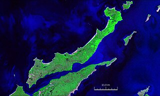
Elcho Island, known to its traditional owners as Galiwin'ku (Galiwinku) is an island off the coast of Arnhem Land, in the Northern Territory of Australia. It is located at the southern end of the Wessel Islands group located in the East Arnhem Region. Galiwin'ku is also the name of the settlement where the island's largest community lives. Elcho Island formed part of the traditional lands of the Yan-nhaŋu, according to Norman Tindale. According to J. C. Jennison, the Aboriginal inhabitants were the Dhuwal, who called themselves the Kokalango Mala
Badu Island Airport is an airport on Badu Island, Queensland, Australia.
Boigu Island Airport is an airport serving Boigu Island in Queensland, Australia. It was officially opened as the Charlie Gibuma Memorial Airstrip on 26 July 1981 by Hon. Ken Tomkins, then Queensland Minister for Aboriginal and Island Affairs. The airport is operated by the Torres Strait Islands Regional Council.
Coconut Island Airport is an airport located on Coconut Island in Queensland, Australia.
Darnley Island Airport is an airport in Darnley Island, Queensland, Australia.
Groote Eylandt Airport is an airport serving Groote Eylandt, an island in the Gulf of Carpentaria in Northern Territory, Australia. The airport is operated by the Groote Eylandt Mining Co. and is located north of the community of Angurugu.
Lizard Island Airport is an airport on Lizard Island National Park in Queensland, Australia. It is served from Cairns by Hinterland Aviation.
Mabuiag Island Airport is an airport on Mabuiag Island, Queensland, Australia. The airport received $52,422 in funds for security updates in 2006. It has Australia's shortest runway in commercial service.
Mornington Island Airport is an airport on Mornington Island, Queensland, Australia. It is to the immediate north-west of the town of Gununa.
Murray Island Airport is an airport on Murray Island, in Queensland, Australia.
Palm Island Airport is an airport in Palm Island, on Great Palm Island, Queensland, Australia.
Saibai Island Airport is an airport on Saibai Island, Queensland, Australia.
Warraber Island Airport is an airport in Sue Islet, Queensland, Australia. It was named Nelson Airport and officially opened on 26 November 1977.
Yam Island Airport is an airport in Yam Island, Queensland, Australia.
Yorke Island Airport is an airport in Yorke Island, Queensland, Australia.
Dunk Island Airport is located on the west side of Dunk Island, Australia, only 5 km (3.1 mi) from Mission Beach. The airport is served from Cairns by Hinterland Aviation, in addition to general aviation charter and private flights.
Troughton Island Airport is located on Troughton Island, in the Kimberley region of Western Australia.


