Cold Brook, New York

Last updated

Cold Brook, New York
Cold Brook, New York.jpg
Signage entering Cold Brook via Herkimer County Route 224, approaching New York State Route 8
USA New York location map.svg
Red pog.svg
Cold Brook
Usa edcp location map.svg
Red pog.svg
Cold Brook
Coordinates: 43°14′27″N75°2′21″W / 43.24083°N 75.03917°W / 43.24083; -75.03917
CountryUnited States
State New York
County Herkimer
Town Russia
Area
[1]
  Total0.44 sq mi (1.14 km2)
  Land0.44 sq mi (1.14 km2)
  Water0.00 sq mi (0.00 km2)
Elevation
945 ft (288 m)
Population
 (2020)
  Total250
  Density569.48/sq mi (219.78/km2)
Time zone UTC-5 (Eastern (EST))
  Summer (DST) UTC-4 (EDT)
ZIP code
13324
Area code 315
FIPS code 36-16815
GNIS feature ID0947025

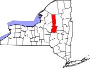
Cold Brook is a village in Herkimer County, New York. The population was 329 at the time of the 2010 census. [2] It is named after a stream passing through the village. The village is located in the south part of the town of Russia and is northeast of Utica.

Contents

History

The water power of Cold Brook encouraged settlers, who arrived after 1800. The 1857 Cold Brook Feed Mill was listed on the National Register of Historic Places in 1974. [3]

Geography

Cold Brook is located at 43°14′27″N75°2′21″W / 43.24083°N 75.03917°W / 43.24083; -75.03917 (43.240968, -75.039221). [4] According to the United States Census Bureau, the village has a total area of 0.44 square miles (1.14 km2), all land. [2] The village is on sloping terrain with occasionally steep roadways.

The main street of Cold Brook is New York State Route 8, which leads northeast 46 miles (74 km) to Speculator in the Adirondacks and southwest 1.5 miles (2.4 km) to Poland. Utica is 16 miles (26 km) to the southeast via NY-8.

Demographics

Historical population
CensusPop.Note
1910 358
1920 261−27.1%
1930 28810.3%
1940 271−5.9%
1950 34226.2%
1960 3728.8%
1970 41311.0%
1980 402−2.7%
1990 310−22.9%
2000 3368.4%
2010 329−2.1%
2020 250−24.0%
U.S. Decennial Census [5]

As of the census [6] of 2000, there were 336 people, 123 households, and 93 families residing in the village. The population density was 761.2 inhabitants per square mile (293.9/km2). There were 133 housing units at an average density of 301.3 per square mile (116.3/km2). The racial makeup of the village was 99.70% White and 0.30% Asian.

There were 123 households, out of which 39.8% had children under the age of 18 living with them, 55.3% were married couples living together, 14.6% had a female householder with no husband present, and 23.6% were non-families. 19.5% of all households were made up of individuals, and 6.5% had someone living alone who was 65 years of age or older. The average household size was 2.73 and the average family size was 3.12.

In the village, the population was spread out, with 31.5% under the age of 18, 7.1% from 18 to 24, 25.6% from 25 to 44, 22.0% from 45 to 64, and 13.7% who were 65 years of age or older. The median age was 34 years. For every 100 females, there were 107.4 males. For every 100 females age 18 and over, there were 101.8 males.

The median income for a household in the village was $30,455, and the median income for a family was $33,333. Males had a median income of $22,500 versus $18,542 for females. The per capita income for the village was $13,674. About 12.0% of families and 10.9% of the population were below the poverty line, including 15.2% of those under age 18 and 8.6% of those age 65 or over.

Related Research Articles

<span class="mw-page-title-main">Utica, Indiana</span> Town in Indiana, United States

Utica is a town in Utica Township, Clark County, Indiana, United States. The population was 776 at the 2010 census.

<span class="mw-page-title-main">Troy, Maine</span> Town in the state of Maine, United States

Troy is a town in Waldo County, Maine, United States. The population was 1,018 at the 2020 census.

<span class="mw-page-title-main">Sweetwater Township, Michigan</span> Civil township in Michigan, United States

Sweetwater Township is a civil township of Lake County in the U.S. state of Michigan. The population was 258 at the 2020 census.

<span class="mw-page-title-main">Utica, Michigan</span> City in Michigan, United States

Utica is a city in Macomb County in the U.S. state of Michigan. The population was 5,245 at the 2020 census, up from 4,757 in 2010.

<span class="mw-page-title-main">Utica, Missouri</span> Village in Missouri, United States

Utica is a village in Livingston County, Missouri, United States. The population was 222 at the 2020 census.

Poland is a village in Herkimer County, New York, United States. The population was 508 at the 2010 census.

<span class="mw-page-title-main">Russia, New York</span> Town in New York, United States

Russia is a town in Herkimer County, New York, United States. The population was 2,269 at the 2020 census, down from 2,587 in 2010. The town is located in the northwestern part of the county and is northeast of Utica.

Clark Mills is a hamlet in Oneida County, New York, United States. The population was 1,905 at the 2010 census.

<span class="mw-page-title-main">Prospect, New York</span> Hamlet in New York, United States

Prospect is a hamlet in the town of Trenton, in Oneida County, New York, United States. The population was 291 at the 2010 census. The hamlet is located at the junction of NY 365 and Reference Route 920V west of West Canada Creek. It was an incorporated village from 1890 to 2015.

<span class="mw-page-title-main">Steuben, New York</span> Town in Oneida County, New York, US

Steuben is a town in Oneida County, New York, United States. The population was 1,110 at the 2010 census. The town is named after Baron von Steuben, a Prussian general who fought on the American side in the American Revolutionary War.

<span class="mw-page-title-main">Westmoreland, New York</span> Town in New York, United States

Westmoreland is a town in Oneida County, New York, United States. The population was 6,138 at the 2010 census.

<span class="mw-page-title-main">Yorkville, Oneida County, New York</span> Village in New York, United States

Yorkville is a village in Oneida County, New York, United States. The population was 2,689 at the 2010 census.

<span class="mw-page-title-main">Boyd, Wisconsin</span> Village in Wisconsin, United States

Boyd is an autonomous village in the town of Delmar, Chippewa County, Wisconsin, United States. The population was 552 at the 2010 census.

<span class="mw-page-title-main">Mattoon, Wisconsin</span> Village in Wisconsin, United States

Mattoon is a village in Shawano County, Wisconsin, United States. The population was 438 at the 2010 census.

<span class="mw-page-title-main">Utica, Ohio</span> Village in Ohio, United States

Utica is a village in Knox and Licking counties in the U.S. state of Ohio, along the North Fork of the Licking River. The population was 2,064 at the 2020 census.

<span class="mw-page-title-main">Greene (village), New York</span> Village in New York, United States

Greene is a village in Chenango County, New York, United States. The population was 1,580 at the 2010 census. The village is named after General Nathanael Greene. It is within the town of Greene and is northeast of Binghamton.

Frankfort is a village in the town of Frankfort, Herkimer County, New York, United States. The population was 2,598 at the 2010 census, out of 7,636 people in the entire town. Like the town, the village is named after an early settler, Lawrence (Lewis) Frank.

<span class="mw-page-title-main">New Hartford (village), New York</span> Village in New York, United States

New Hartford is a village in Oneida County, New York, United States. The population was 1,847 at the 2010 census. The name was provided by early settlers from New Hartford, Connecticut.

<span class="mw-page-title-main">Remsen (village), New York</span> Village in New York, United States

Remsen is a village in Oneida County, New York, United States. The population was 431 at the 2020 census.

<span class="mw-page-title-main">Camillus (village), New York</span> Village in New York, United States

Camillus is a village in Onondaga County, New York, United States. As of the 2020 census, the population was 1,222. The village takes its name from the town in which it is located. It is part of the Syracuse Metropolitan Statistical Area.

References

  1. "ArcGIS REST Services Directory". United States Census Bureau. Retrieved September 20, 2022.
  2. 1 2 "Geographic Identifiers: 2010 Census Summary File 1 (G001): Cold Brook village, New York". American Factfinder. U.S. Census Bureau. Archived from the original on February 13, 2020. Retrieved December 1, 2017.
  3. "National Register Information System". National Register of Historic Places . National Park Service. March 13, 2009.
  4. "US Gazetteer files: 2010, 2000, and 1990". United States Census Bureau. February 12, 2011. Retrieved April 23, 2011.
  5. "Census of Population and Housing". Census.gov. Retrieved June 4, 2015.
  6. "U.S. Census website". United States Census Bureau . Retrieved January 31, 2008.