Schuyler, New York

Last updated

There is also a Schuyler County, New York .
Schuyler, New York
Schuyler Herkimer NY.png
Location of Schuyler in Herkimer County
USA New York location map.svg
Red pog.svg
Schuyler
Usa edcp location map.svg
Red pog.svg
Schuyler
Coordinates: 43°5′46″N75°5′53″W / 43.09611°N 75.09806°W / 43.09611; -75.09806
CountryUnited States
State New York
County Herkimer
Government
  Type Town Council
   Town Supervisor Anthony J. Lucenti (R)
   Town Council
Members' List
Area
[1]
  Total40.23 sq mi (104.20 km2)
  Land39.87 sq mi (103.27 km2)
  Water0.36 sq mi (0.93 km2)
Elevation
669 ft (204 m)
Population
 (2010)
  Total3,420
  Estimate 
(2016) [2]
3,352
  Density84.06/sq mi (32.46/km2)
Time zone UTC-5 (Eastern (EST))
  Summer (DST) UTC-4 (EDT)
ZIP codes
13340, 13350, 13416, 13431, 13502
Area code 315
FIPS code 36-043-65695
GNIS feature ID0979473
Website townofschuyler.com

Schuyler is a town in Herkimer County, New York, United States. The population was 3,420 at the 2010 census. [3] The town is in the western part of Herkimer County and is east of Utica.

Contents

History

The area was first settled circa 1765. The town of Schuyler was formed in 1792 from part of the town of Herkimer. In 1797, part of Schuyler was taken to form the newer town of Trenton. Schuyler was further reduced in 1798 to form the town of Deerfield (Oneida County) and in 1806 to form the town of Newport.

Geography

According to the United States Census Bureau, the town of Schuyler has a total area of 40.2 square miles (104.2 km2), of which 39.9 square miles (103.3 km2) are land and 0.3 square miles (0.9 km2), or 0.89%, are water. [3]

The western town line is the border of Oneida County, and the southern town line is marked by the Mohawk River.

The New York State Thruway (Interstate 90) and the Erie Canal pass across the southern part of the town, and the Schuyler Travel Plaza is on the westbound side of the Thruway within the town.

Demographics

Historical population
CensusPop.Note
1820 1,837
1830 2,07412.9%
1840 1,798−13.3%
1850 1,696−5.7%
1860 1,7151.1%
1870 1,558−9.2%
1880 1,452−6.8%
1890 1,259−13.3%
1900 1,3658.4%
1910 1,227−10.1%
1920 1,007−17.9%
1930 1,14613.8%
1940 1,1762.6%
1950 1,169−0.6%
1960 1,89361.9%
1970 2,80848.3%
1980 2,8862.8%
1990 3,50821.6%
2000 3,385−3.5%
2010 3,4201.0%
2016 (est.)3,352 [2] −2.0%
U.S. Decennial Census [4]

As of the census [5] of 2000, there were 3,385 people, 1,418 households, and 937 families residing in the town. The population density was 85.0 inhabitants per square mile (32.8/km2). There were 1,541 housing units at an average density of 38.7 per square mile (14.9/km2). The racial makeup of the town was 97.96% White, 0.50% African American, 0.03% Native American, 0.44% Asian, 0.06% Pacific Islander, 0.15% from other races, and 0.86% from two or more races. Hispanic or Latino of any race were 0.62% of the population.

There were 1,418 households, out of which 28.9% had children under the age of 18 living with them, 50.9% were married couples living together, 10.9% had a female householder with no husband present, and 33.9% were non-families. 28.4% of all households were made up of individuals, and 12.4% had someone living alone who was 65 years of age or older. The average household size was 2.38 and the average family size was 2.93.

In the town, the population was spread out, with 23.8% under the age of 18, 6.5% from 18 to 24, 28.9% from 25 to 44, 25.3% from 45 to 64, and 15.5% who were 65 years of age or older. The median age was 40 years. For every 100 females, there were 95.3 males. For every 100 females age 18 and over, there were 90.9 males.

The median income for a household in the town was $35,375, and the median income for a family was $42,500. Males had a median income of $30,078 versus $22,407 for females. The per capita income for the town was $18,205. About 6.4% of families and 9.4% of the population were below the poverty line, including 14.8% of those under age 18 and 9.1% of those age 65 or over.

Communities and locations in Schuyler, New York

Related Research Articles

<span class="mw-page-title-main">Columbia, New York</span> Town in New York, United States

Columbia is a town in Herkimer County, New York, United States. As of the 2020 census, the town population was 1,569. The town is at the southern border of the county and is southeast of Utica.

<span class="mw-page-title-main">Danube, New York</span> Town in New York, United States

Danube is a town in Herkimer County, New York, United States. The population was 801 at the 2020 census, down from 1,039 in 2010. Early Palatine German immigrants in the eighteenth century named the town after the Danube River in Europe.

<span class="mw-page-title-main">Litchfield, New York</span> Town in New York, United States

Litchfield is a town in Herkimer County, New York, United States. The population was 1,513 at the 2010 census. The town is named after Litchfield, Connecticut, the source of some early settlers of the city.

<span class="mw-page-title-main">Ohio, New York</span> Town in New York, United States

Ohio is a town in Herkimer County, New York, United States. The population was 1,002 at the 2010 census. The town is named after the state of Ohio. The town is in the northern part of the county and northeast of Utica. Part of Ohio is within the Adirondack Park.

<span class="mw-page-title-main">Russia, New York</span> Town in New York, United States

Russia is a town in Herkimer County, New York, United States. The population was 2,269 at the 2020 census, down from 2,587 in 2010. The town is located in the northwestern part of the county and is northeast of Utica.

<span class="mw-page-title-main">Winfield (town), New York</span> Town in New York, United States

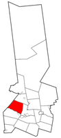
Winfield is a town in Herkimer County, New York, United States. The population was 2,086 at the 2010 census. The town is named after General Winfield Scott and is in the southwestern corner of the county, south of Utica.

Lenox is a town in Madison County, New York, United States. The population was 8,768 as of the 2020 census.

<span class="mw-page-title-main">Sullivan, New York</span> Town in Madison County, New York, US

Sullivan is a town in Madison County, New York, United States. The population was 15,339 at the 2010 census. The town is named after General John Sullivan.

<span class="mw-page-title-main">Deerfield, New York</span> Town in New York, United States

Deerfield is a town in Oneida County, New York, United States. The population was 4,273 at the 2010 census.

<span class="mw-page-title-main">Forestport, New York</span> Town in New York, United States

Forestport is a town in Oneida County, New York, United States. The population was 1,477 at the 2020 census.

<span class="mw-page-title-main">Paris, New York</span> Town in New York, United States

Paris is a town in Oneida County, New York, United States. The town is in the southeast part of the county and is south of Utica. The population was 4,332 at the 2020 census. The town was named after an early benefactor, Colonel Isaac Paris.

<span class="mw-page-title-main">Sangerfield, New York</span> Town in New York, United States

Sangerfield is a town in Oneida County, New York, United States. The population was 2,561 at the 2010 census. The town is named after Jedediah Sanger, an early settler.

<span class="mw-page-title-main">Trenton, New York</span> Town in New York, United States

Trenton is a town in Oneida County, New York, United States. The population was 4,297 at the 2020 census.

<span class="mw-page-title-main">Verona, New York</span> Town in New York, United States

Verona is a town in southwestern Oneida County, New York, United States. The population was 6,293 at the 2010 census. The town was named after Verona, Italy.

<span class="mw-page-title-main">Westmoreland, New York</span> Town in New York, United States

Westmoreland is a town in Oneida County, New York, United States. The population was 6,138 at the 2010 census.

<span class="mw-page-title-main">Whitestown, New York</span> Town in New York, United States

Whitestown is a town in Oneida County, New York, United States. The population was 18,667 at the 2010 census. The name is derived from Judge Hugh White, an early settler. The town is immediately west of Utica and the New York State Thruway passes across the town. The offices of the town of Whitestown are in the Village of Whitesboro.

<span class="mw-page-title-main">Frankfort, New York</span> Town in New York, United States

Frankfort is a town in Herkimer County, New York, United States. The town is named after one of its earliest settlers, Lawrence (Lewis) Frank. The town of Frankfort includes a village, also called Frankfort. Frankfort is located east of Utica, and the Erie Canal passes along its northern border. At the time of the 2020 census, the population was 7,011, down from 7,636 in 2010.

<span class="mw-page-title-main">Herkimer, New York</span> Town in New York, United States

Herkimer is a town in Herkimer County, New York, United States, southeast of Utica. It is named after Nicholas Herkimer. The population was 9,566 at the 2020 census, down from 10,175 in 2010.

<span class="mw-page-title-main">Newport, New York</span> Town in New York, United States

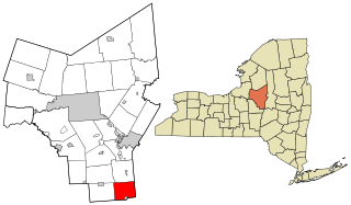
Newport is a town in Herkimer County, New York, United States. The population was 2,302 at the 2010 census. The town, located on the western edge of the county, contains the village of Newport. The town is northeast of Utica.

<span class="mw-page-title-main">Bridgewater, New York</span> Town in New York, United States

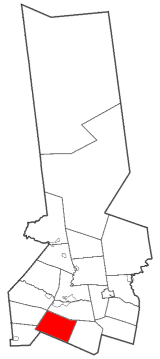
Bridgewater is a town in Oneida County, New York, United States. The population was 1,522 at the 2010 census.

References

  1. "2016 U.S. Gazetteer Files". United States Census Bureau. Retrieved July 5, 2017.
  2. 1 2 "Population and Housing Unit Estimates" . Retrieved June 9, 2017.
  3. 1 2 "Geographic Identifiers: 2010 Census Summary File 1 (G001): Schuyler town, Herkimer County, New York". American Factfinder. U.S. Census Bureau. Archived from the original on February 13, 2020. Retrieved November 30, 2017.
  4. "Census of Population and Housing". Census.gov. Retrieved June 4, 2015.
  5. "U.S. Census website". United States Census Bureau . Retrieved January 31, 2008.