German Flatts is a town in Herkimer County, New York, United States. The population was 13,258 at the 2010 census.
Ilion is a village in Herkimer County, New York, United States. The population was 7,790 at the 2017 census.
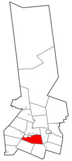
Frankfort is a village in the town of Frankfort, Herkimer County, New York, United States. The population was 2,598 at the 2010 census, out of 7,636 people in the entire town. Like the town, the village is named after an early settler, Lawrence (Lewis) Frank.

Frankfort is a town in Herkimer County, New York, United States. The town is named after one of its earliest settlers, Lawrence (Lewis) Frank. The town of Frankfort includes a village, also called Frankfort. Frankfort is located east of Utica, and the Erie Canal passes along its northern border. At the time of the 2010 census, the population was 7,636.

Herkimer is a town in Herkimer County, New York, United States, southeast of Utica. It is named after Nicholas Herkimer. The population was 10,175 at the 2010 census.

New York State Route 28 (NY 28) is a state highway extending for 281.69 miles (453.34 km) in the shape of a "C" between the Hudson Valley city of Kingston and southern Warren County in the U.S. state of New York. Along the way, it intersects several major routes, including Interstate 88 (I-88), U.S. Route 20 (US 20), and the New York State Thruway twice. The southern terminus of NY 28 is at NY 32 in Kingston and the northern terminus is at US 9 in Warrensburg. In Kingston, NY 28 is co-designated as Interstate 587 from its southern terminus at NY 32 to the roundabout linking it to the Thruway (I-87).

Cuylerville is a hamlet in the Town of Leicester, in Livingston County, New York, United States. The population was 297 at the 2010 census, which lists the community as a census-designated place.

New York State Route 5S (NY 5S) is a 72.92-mile-long (117.35 km) east–west state highway located in the Mohawk Valley of New York in the United States. It extends from a continuation of NY 5A at an interchange with NY 5, NY 8, NY 12, and Interstate 790 (I-790) in Utica to an interchange with NY 890 in Rotterdam. The route runs along the south side of the Mohawk River for its entire length and parallels NY 5, which runs along the north side of the Mohawk River. NY 5S intersects several primary routes including NY 28 in Mohawk, NY 30A in Fultonville, NY 30 south of Amsterdam, as well as intersecting the New York State Thruway (I-90) several times. The route is part of New York State Bicycle Route 5 west of its junction with NY 103 in Schenectady County.
East Avon is a hamlet and census-designated place (CDP) in the town of Avon, Livingston County, New York, United States. The population was 608 at the 2010 census.

New York State Route 171 (NY 171) is a state highway running east to west through Herkimer County, New York, in the United States. It connects the hamlet of Gulph in the town of Frankfort to the village of Frankfort by way of the Frankfort Gorge. Its western end is at the junction of County Route 145 (CR 145) and CR 185 southeast of Gulph. The eastern end is 5.69 miles (9.16 km) to the east at an intersection with Main Street in Frankfort village. NY 171 is a narrow, two-lane highway for its whole length.
Port Gibson is a hamlet and census-designated place (CDP) in the town of Manchester, Ontario County, New York, United States. As of the 2010 census, it had a population of 453.
Dalton is a hamlet and census-designated place (CDP) in the towns of Nunda and Portage in Livingston County, New York, United States. The population was 362 at the 2010 census.
Blodgett Mills is a hamlet and census-designated place (CDP) in Cortland County, New York, United States. The population was 303 at the 2010 census. It is in the town of Cortlandville, southeast of the city of Cortland.
Rodman is a hamlet and census-designated place (CDP) in the town of Rodman, Jefferson County, New York, United States. As of the 2010 census, the CDP population was 153, out of 1,176 in the entire town of Rodman.
Campbell is the primary hamlet and a census-designated place (CDP) in the town of Campbell in Steuben County, New York, United States. As of the 2010 census, it had a population of 713, out of 3,406 in the entire town of Campbell.
Woodsville is a hamlet and census-designated place (CDP) in Livingston County, New York, United States. Its population was 80 as of the 2010 census. New York State Route 36 passes through the community.
Pamelia Center is a hamlet and census-designated place (CDP) in Jefferson County, New York, United States. Its population was 264 as of the 2010 census. The community is located at the junction of New York State Route 37 and New York State Route 342.
Cementon is a hamlet and census-designated place (CDP) in the town of Catskill in Greene County, New York, United States. It was first listed as a CDP prior to the 2020 census.
East Herkimer is a hamlet and census-designated place (CDP) in the town of Herkimer in Herkimer County, New York, United States. It was first listed as a CDP prior to the 2020 census.
South Ilion is a hamlet and census-designated place (CDP) in the town of German Flatts in Herkimer County, New York, United States. It was first listed as a CDP prior to the 2020 census.


