
The Columbia River is the largest river in the Pacific Northwest region of North America. The river rises in the Rocky Mountains of British Columbia, Canada. It flows northwest and then south into the US state of Washington, then turns west to form most of the border between Washington and the state of Oregon before emptying into the Pacific Ocean. The river is 1,243 miles (2,000 km) long, and its largest tributary is the Snake River. Its drainage basin is roughly the size of France and extends into seven US states and a Canadian province. The fourth-largest river in the United States by volume, the Columbia has the greatest flow of any North American river entering the Pacific. The Columbia has the 37th greatest discharge of any river in the world.

Columbia University is a private Ivy League research university in New York City. Established in 1754 as King's College on the grounds of Trinity Church in Manhattan, Columbia is the oldest institution of higher education in New York and the fifth-oldest institution of higher learning in the United States. It is one of nine colonial colleges founded prior to the Declaration of Independence, seven of which belong to the Ivy League. Columbia is ranked among the top universities in the world by major education publications.

The Rocky Mountains, also known as the Rockies, are a major mountain range and the largest mountain system in North America. The Rocky Mountains stretch 3,000 mi (4,800 km) in straight-line distance from the northernmost part of western Canada, to New Mexico in southwestern United States. Depending on differing definitions between Canada and the United States, its northern terminus is located either in northern British Columbia's Terminal Range south of the Liard River and east of the Trench, or in the northeastern foothills of the Brooks Range/British Mountains that face the Beaufort Sea coasts between the Canning River and the Firth River across the Alaska-Yukon border. Its southernmost point is near the Albuquerque area adjacent to the Rio Grande Basin and north of the Sandia–Manzano Mountain Range. Being the easternmost portion of the North American Cordillera, the Rockies are distinct from the tectonically younger Cascade Range and Sierra Nevada, which both lie farther to its west.

{{short description|State of the United States}
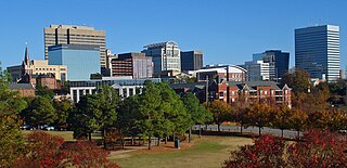
Columbia is the capital and second-largest city of the U.S. state of South Carolina, with a population estimate of 131,674 as of 2019. The city serves as the county seat of Richland County, and a portion of the city extends into neighboring Lexington County. It is the center of the Columbia metropolitan statistical area, which had a population of 767,598 as of the 2010 United States Census, growing to 832,666 by July 1, 2018, according to 2018 U.S. Census estimates. This makes it the 70th-largest metropolitan statistical area in the nation, as estimated by the United States Census Bureau as of July 1, 2018. The name Columbia is a poetic term used for the United States, derived from the name of Christopher Columbus, who explored for the Spanish Crown. Columbia is often abbreviated as Cola, leading to its nickname as "Soda City."
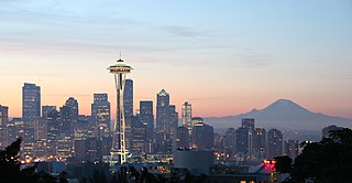
The Pacific Northwest (PNW) is a geographic region in western North America bounded by its coastal waters of the Pacific Ocean to the west and, loosely, by the Rocky Mountains to the east. Though no official boundary exists, the most common conception includes the U.S. states of Oregon, Washington, and Idaho and the Canadian province of British Columbia. Some broader conceptions reach north into Alaska and Yukon and south into northern California. Other conceptions may be limited to the coastal areas west of the Cascade and Coast mountains. The variety of definitions can be attributed to partially overlapping commonalities of the region's history, culture, geography, society, and other factors. The city of Seattle in Washington is sometimes considered the "capital" of the Pacific Northwest, while Portland, Oregon and Vancouver, British Columbia are also generally included in the region.

The contiguous United States or officially the conterminous United States consists of the 48 adjoining U.S. states on the continent of North America. The terms exclude the non-contiguous states of Alaska and Hawaii, and all other offshore insular areas, such as American Samoa, Guam, the Northern Mariana Islands, Puerto Rico, and the U.S. Virgin Islands. These differ from the related term continental United States, which includes Alaska but excludes the Hawaiian Islands and all U.S. territories in the Caribbean and the Pacific.

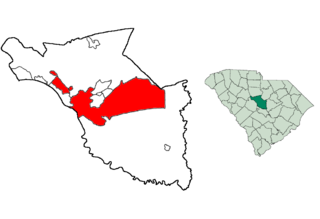
Richland County is located in the U.S. state of South Carolina. As of the 2010 census, the population was 384,504, making it the second-most populous county in South Carolina, behind only Greenville County. The 2019 estimated population was 415,759. The county seat and largest city is Columbia, the state capital. The county was founded in 1785. Richland County is part of the Columbia, SC Metropolitan Statistical Area. In 2010, the center of population of South Carolina was located in Richland County, in the city of Columbia.

Columbia County is a county located in the north-central part of the U.S. state of Pennsylvania. As of the 2010 census, the population was 67,295. Its county seat is Bloomsburg. The county was created on March 22, 1813, from part of Northumberland County. It was named Columbia, alluding to the United States and Christopher Columbus.

Washington, D.C., formally the District of Columbia and also known as D.C. or just Washington, is the capital city of the United States. It is located on the east bank of the Potomac River which forms its southwestern and southern border with Virginia, and shares a land border with Maryland on its remaining sides. The city was named for George Washington, the first president of the United States and a Founding Father, and the federal district is named after Columbia, a female personification of the nation. As the seat of the U.S. federal government and several international organizations, the city is an important world political capital. It is one of the most visited cities in the U.S., seeing over 20 million visitors in 2016.

West Columbia is a city and commuter town in the suburban eastern sections of Lexington County, South Carolina, United States. According to the 2010 census, the population was 14,988, and the 2019 population estimate was 17,998. West Columbia is bordered to the east by Columbia, the state capital, across the Congaree River. It is near Columbia's city center or downtown district as well as the South Carolina State House and the Congaree Vista, known locally as "the Vista." The city is bordered to the south by its sister suburb, Cayce. A small portion of the city borders the town of Lexington to the east. West Columbia is part of the greater Columbia, SC metropolitan statistical area.

The Northeastern United States is a geographical region of the United States bordered to the north by Canada, to the east by the Atlantic Ocean, to the south by the Southern United States, and to the west by the Midwestern United States. The Northeast is one of the four regions defined by the United States Census Bureau for the collection and analysis of statistics.

The South Atlantic United States form one of the nine Census Bureau Divisions within the United States that are recognized by the United States Census Bureau. This region, U.S. Census Bureau Region 3, Division 5, corresponds to the South with the addition of Florida.

Columbia is the female national personification of the United States. It was also a historical name applied to the Americas and to the New World. The association has given rise to the names of many American places, objects, institutions and companies, including the District of Columbia; Columbia, South Carolina; Columbia University; "Hail, Columbia" and Columbia Rediviva; the Columbia River; and the Canadian province of British Columbia. Images of the Statue of Liberty largely displaced personified Columbia as the female symbol of the United States by around 1920, although Lady Liberty was seen as an aspect of Columbia. However, Columbia's most prominent display today is being part of the logo of the Hollywood film studio Columbia Pictures.
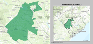
The 2nd congressional district of South Carolina is in central and southwestern South Carolina. The district spans from Columbia to the South Carolina side of the Augusta, Georgia metropolitan area.
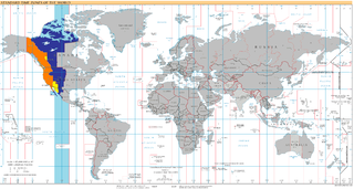
UTC−07:00 is an identifier for a time offset from UTC of −07:00. In North America, it is observed in the Mountain Time Zone during standard time, and in the Pacific Time Zone during the other eight months. Some locations use it year-round.

Yahk Provincial Park is a provincial park located just south of Yahk, British Columbia, 70 kilometres south of Cranbrook, and 14.5 kilometres north of the Canada–United States border at Kingsgate in British Columbia, Canada.
This is a list of the National Register of Historic Places listings in Columbia, South Carolina.


