Columbia-Tusculum, Cincinnati

Last updated

Columbia-Tusculum
Eastern Avenue, Columbia-Tusculum, Cincinnati, OH (46508263295).jpg
Eastern Avenue in Columbia-Tusculum, Cincinnati
Flag of Columbia Tusculum, Cincinnati, Ohio.svg
Columbia-Tusculum-Cincinnati-map.jpg
Columbia-Tusculum (red) within Cincinnati, Ohio
Country United States
State Ohio
County Hamilton
City Cincinnati
Population
 (2020)
  Total1,523

Columbia-Tusculum is one of the 52 neighborhoods of Cincinnati, Ohio. Founded in 1788 and annexed in 1871, it is the city's oldest neighborhood. The population was 1,523 at the 2020 census. [1]

Contents

History

Columbia was founded in 1788 on the Little Miami River and predates Losantiville (which became Cincinnati) by a month. [2] The first Protestant church (Baptist) in the Northwest Territory was erected in Columbia. [3] The Cincinnati area's first school opened here in 1790. Many of the early settlers are buried in the former Columbia Baptist Cemetery, founded in 1790. The cemetery is now known as the Pioneer Memorial Cemetery.

In 1791, Columbia became part of Columbia Township. From the early 1840s, it was included in Spencer Township, [4] [5] until Cincinnati annexed it in 1871. [6] Tusculum was annexed in 1875. [7]

Stephen Decker Rowhouse StephenDeckerRowhouse.jpg
Stephen Decker Rowhouse

The neighborhood is noted for its Victorian era homes decorated in the painted ladies multi-color style. [8] Designated historic structures in the neighborhood include the Bates Building, Kellogg House, LuNeack House, Norwell Residence, Spencer Township Hall, and the Stephen Decker Rowhouse.

Demographics

Population of 1990-2020[ citation needed ]
YearPop.±%
1990 3,051    
2000 3,081+1.0%
2010 1,304−57.7%
2020 1,523+16.8%
Boundaries of neighborhood changed in 2010 - reflective of population decrease.

As of the census of 2020, there were 1,523 people living in the neighborhood. There were 795 housing units. The racial makeup of the neighborhood was 88.0% White, 2.2% Black or African American, 0.0% Native American, 3.9% Asian, 0.0% Pacific Islander, 0.2% from some other race, and 5.6% from two or more races. 2.3% of the population were Hispanic or Latino of any race. [1]

There were 684 households, out of which 40.2% were families. 41.5% of all households were made up of individuals. [1]

15.0% of the neighborhood's population were under the age of 18, 79.0% were 18 to 64, and 6.0% were 65 years of age or older. 47.0% of the population were male and 53.0% were female. [1]

According to the U.S. Census American Community Survey, for the period 2016-2020 the estimated median annual income for a household in the neighborhood was $113,194. About 0.0% of family households were living below the poverty line. About 74.5% had a bachelor's degree or higher. [1]

Further reading

Related Research Articles

<span class="mw-page-title-main">Columbia Township, Hamilton County, Ohio</span> Township in Ohio, United States

Columbia Township is one of the twelve townships of Hamilton County, Ohio, United States. The 2020 census found 4,446 people in the township. Originally one of Ohio's largest townships by area at its inception in 1791, it gradually shrank to one of the smallest by the early 1950s.

<span class="mw-page-title-main">Mill Creek Township, Hamilton County, Ohio</span>

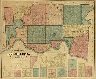
Millcreek Township is a survey township in south-central Hamilton County, Ohio, that also existed as a civil township from 1810 until 1943. Once the most important township in the county, it was largely absorbed by Cincinnati and its suburbs, nominally remaining as a paper township from 1943 until 1953. It was abolished when the rest of its unincorporated territory, consisting of Wesleyan Cemetery, became part of Cincinnati. As the original survey township covers a large portion of present-day Cincinnati, references to it are frequently encountered by genealogists.

<span class="mw-page-title-main">Bond Hill, Cincinnati</span> Neighborhood of Cincinnati in Hamilton, Ohio, United States

Bond Hill is one of the 52 neighborhoods of Cincinnati, Ohio. Founded as a railroad suburb and temperance community in 1870 in northeastern Millcreek Township, it is one of a number of neighborhoods lining the Mill Creek. The population was 7,002 at the 2020 census.

<span class="mw-page-title-main">Evanston, Cincinnati</span> Neighborhood in Cincinnati, Ohio, United States

Evanston is one of the 52 neighborhoods of Cincinnati, Ohio. A mostly African-American neighborhood since the 1960s, it is known as "the educating community", and is bordered by the neighborhoods of East Walnut Hills, Hyde Park, North Avondale, and Walnut Hills, as well as the City of Norwood. The population was 8,838 at the 2020 census.

<span class="mw-page-title-main">Mount Washington, Cincinnati</span> Neighborhood of Cincinnati in Hamilton, Ohio, United States

Mount Washington is one of the 52 neighborhoods of Cincinnati, Ohio, United States. It borders the neighborhoods of California and the East End, as well as Anderson Township, Hamilton County, Ohio. The population was 20,540 at the 2020 census.

<span class="mw-page-title-main">Clifton, Cincinnati</span> Neighborhood of Cincinnati in Ohio, United States

Clifton is one of the 52 neighborhoods of Cincinnati, Ohio. The population was 8,408 in the 2020 census.

<span class="mw-page-title-main">Pleasant Ridge, Cincinnati</span> Neighborhood of Cincinnati in Hamilton, Ohio, United States

Pleasant Ridge is one of the 52 neighborhoods of Cincinnati, Ohio. Annexed in 1911, the neighborhood is predominately residential. The population was 8,895 at the 2020 census.

<span class="mw-page-title-main">Hyde Park, Cincinnati</span> Neighborhood of Cincinnati in Ohio, United States

Hyde Park is one of the 52 neighborhoods of Cincinnati, Ohio. Originally established as a retreat for the city's wealthy, the neighborhood is predominately residential, with a central business district known as Hyde Park Square. The population was 14,193 at the 2020 census.

<span class="mw-page-title-main">Westwood, Cincinnati</span> Neighborhood of Cincinnati in Hamilton, Ohio, United States

Westwood is one of the 52 neighborhoods of Cincinnati, Ohio. Annexed in 1896 and located in the western part of the city, it is the city's largest neighborhood in both area and population. The population was 33,774 at the 2020 census.

<span class="mw-page-title-main">Spencer Township Hall</span> United States historic place

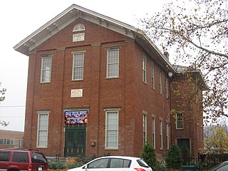
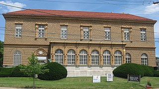
The Spencer Township Hall is a historic former government building in the Columbia-Tusculum neighborhood of Cincinnati, Ohio, United States. One of Cincinnati's oldest extant public buildings, it has been designated a historic site because of its architecture.

<span class="mw-page-title-main">Carthage, Cincinnati</span> Neighborhood of Cincinnati in Hamilton, Ohio, United States

Carthage is one of the 52 neighborhoods of Cincinnati, Ohio. Established in 1791 or 1792 and annexed in 1911, it is located in the northern part of the city's Mill Creek valley. The neighborhood is predominately residential, and is center of the city's Hispanic community. It shares a border with Elmwood Place, Ohio, which, with adjacent St. Bernard, Ohio, forms an enclave in the middle of Cincinnati. The population was 2,781 at the 2020 census.

<span class="mw-page-title-main">Linwood, Cincinnati</span> Neighborhood of Cincinnati in Hamilton, Ohio, United States

Linwood is one of the 52 neighborhoods of Cincinnati, Ohio, United States. Annexed in 1893, it is located in the eastern part of the city. The population was 705 at the 2020 census.

<span class="mw-page-title-main">Madisonville, Cincinnati</span> Neighborhood of Cincinnati in Ohio, United States

Madisonville is one of the 52 neighborhoods of Cincinnati, Ohio. Established in 1809 and annexed in 1911, it is located in the northeastern part of the city. The population was 17,898 at the 2020 census.

<span class="mw-page-title-main">Mount Airy, Cincinnati</span> Neighborhood of Cincinnati in Hamilton, Ohio, United States

Mount Airy is one of the 52 neighborhoods of Cincinnati, Ohio. The neighborhood is home to Mount Airy Forest, one of the oldest urban reforestation projects in the country. The population was 9,210 at the 2020 census.

<span class="mw-page-title-main">Riverside, Cincinnati</span> Neighborhood of Cincinnati in Hamilton, Ohio, United States

Riverside is one of the 52 neighborhoods of Cincinnati, Ohio. The neighborhood is contained in a narrow strip of land along the Ohio River on the city's west side, between Sayler Park and Sedamsville. Predominately industrial, the neighborhood has few residential areas, with a population of 1,257 at the 2020 census.

<span class="mw-page-title-main">Sayler Park, Cincinnati</span> Neighborhood of Cincinnati in Hamilton, Ohio, United States

Sayler Park is one of the 52 neighborhoods of Cincinnati, Ohio. Situated along the Ohio River, it is the westernmost neighborhood in the city. The population was 2,825 at the 2020 census.

<span class="mw-page-title-main">Hartwell, Cincinnati</span> Neighborhood of Cincinnati in Hamilton, Ohio, United States

Hartwell is one of the 52 neighborhoods of Cincinnati, Ohio. Established in 1868 and annexed in 1912, it is the city's northernmost neighborhood, centered roughly on the intersections of I-75 and Ronald Reagan Cross County Highway. Its boundaries are a combination of Caldwell Park and Ronald Reagan Cross County Highway to the south, I-75 to the east, and a combination of Millsdale Street and Compton Road to the North. The population was 5,806 at the 2020 census.

<span class="mw-page-title-main">John Reily</span>

John Reily (1763-1850) was a soldier in the American Revolution who later held a number of civic positions including helping draft the Ohio State Constitution. Reily Township in Butler County, Ohio is named for him.

<span class="mw-page-title-main">Spencer Township, Hamilton County, Ohio</span>

Spencer Township was a civil township in southeastern Hamilton County, Ohio. It was established in the early 1840s and annexed to Cincinnati in stages from 1855 to 1909.

Cincinnati Township is a paper township and former civil township in south-central Hamilton County, Ohio. Originally one of Ohio's largest townships by area at its inception in 1791, it was abolished in 1834 when the City of Cincinnati became coextensive with it through annexation. Since then, it has remained solely as a paper township.

References

  1. 1 2 3 4 5 "Columbia Tusculum 2020 Statistical Neighborhood Approximation" (PDF). City of Cincinnati. Retrieved December 13, 2023.
  2. Edwards, Jennifer (December 29, 2003). "Columbia Tusculum redo planned". Cincinnati Enquirer . Cincinnati.com. Retrieved May 14, 2021.
  3. Clarke, S. J. (1912). Cincinnati, the Queen City, 1788-1912, Volume 2. The S. J. Clarke Publishing Company. p. 530. Archived from the original on May 5, 2016. Retrieved May 20, 2013.
  4. Ford & Ford 1881, p. 347.
  5. Nelson & Runk 1894, p. 387.
  6. Goss, Charles Frederic (1912). Cincinnati, the Queen City, 1788–1912. Vol. 2. Cincinnati: S. J. Clarke Publishing Company. p. 528 via Google Books.
  7. Hale, Harry L. (February 5, 1961). "Tusculum Once Known For Wealth Of Residents". The Cincinnati Enquirer. p. 7D via Newspapers.com.
  8. Agran, Hannah (October 2002). "Restoration Heaven: Comumbia-Tusculum is a Hot Spot for Painted Ladies". Cincinnati Magazine. p. 54. Archived from the original on May 14, 2021. Retrieved May 8, 2013.

39°7′N84°26′W / 39.117°N 84.433°W / 39.117; -84.433