East Walnut Hills, Cincinnati

Last updated
East Walnut Hills
Bulluck Terrace Condos, East Walnut Hills, Cincinnati, OH (46464066175).jpg
Bulluck Terrace Condos, East Walnut Hills, Cincinnati
Flag of East Walnut Hills, Cincinnati, Ohio.svg
East-Walnut-Hills-Cincinnati-map.jpg
East Walnut Hills is a neighborhood of Cincinnati, Ohio
Country United States
State Ohio
City Cincinnati
Population
 (2020)
  Total4,103

East Walnut Hills is a neighborhood on the east side of Cincinnati, Ohio. The population was 4,103 at the 2020 census. [1]

Contents

History

Founded in 1867 as the incorporated Village of Woodburn, East Walnut Hills is known as the home to many prominent Cincinnatians.[ citation needed ] Initially developed by combining a small German Catholic community and the suburban estates of Cincinnati businessmen, the village was annexed into Cincinnati by 1873. [2]

Historic architecture and former residents

The neighborhood includes a historic district between the O'Bryonville business district (Evanston) and the DeSales Corner, home to mansions with large setbacks, as well as Annwood Park on Madison Road and the Bettman Preserve, an urban nature preserve.[ citation needed ] Large estates line William Howard Taft Road, with views of the Ohio River and Downtown Cincinnati. Many older homes in the areas surrounding St. Ursula Academy are being subdivided and converted into condominiums.[ citation needed ] East Walnut Hills is home to the historic Saint Francis De Sales Catholic Church and School, at the intersection of Madison Road and Woodburn Avenue and Purcell Marian High School. East Walnut Hills' historic homes demonstrate several architectural styles. Examples of the Romantic period, Colonial Revival, Tudor Revival, Queen Ann, Romanesque, Italian Revival, and English Country Revival can be seen. The homes of East Walnut Hills are often featured in local historic home and garden tours.[ citation needed ]

Formerly known as Madisonville Pike in the early 1850s, Madison Road is the site of the earliest development in the neighborhood.[ citation needed ] The historic John S. Baker House was designed by Cincinnati Architect James Keys Wilson.[ citation needed ] Other prominent East Walnut Hills residents are William W. Scarborough, grocery merchant, Joshua Hall Bates, a Union general who built his home in 1858,[ citation needed ] and Civil War veteran and heir to a liquor baron Charles Dexter. [3]

The neighborhood is known as an urban forest because of the number of large trees.[ citation needed ] There is also a bird sanctuary between Wold Ave and Dexter Place.[ citation needed ]

Demographics

Population of East Walnut Hills 1900-2020[ citation needed ]
YearPop.±%
1900 3,325    
1910 3,977+19.6%
1920 4,925+23.8%
1930 5,217+5.9%
1940 5,543+6.2%
1950 6,018+8.6%
1960 5,350−11.1%
1970 5,425+1.4%
1980 4,106−24.3%
1990 3,741−8.9%
2000 3,630−3.0%
2010 3,794+4.5%
2020 4,103+8.1%

As of the census of 2020, there were 4,103 people living in the neighborhood. There were 2,715 housing units. The racial makeup of the neighborhood was 70.9% White, 18.0% Black or African American, 0.2% Native American, 2.9% Asian, 0.2% Pacific Islander, 1.2% from some other race, and 6.6% from two or more races. 3.2% of the population were Hispanic or Latino of any race. [1]

There were 2,346 households, out of which 33.1% were families. 56.7% of all households were made up of individuals. [1]

6.2% of the neighborhood's population were under the age of 18, 73.0% were 18 to 64, and 20.8% were 65 years of age or older. 40.2% of the population were male and 59.8% were female. [1]

According to the U.S. Census American Community Survey, for the period 2016-2020 the estimated median annual income for a household in the neighborhood was $67,407. About 2.9% of family households were living below the poverty line. About 70.7% had a bachelor's degree or higher. [1]

See also

Related Research Articles

<span class="mw-page-title-main">Wyoming, Ohio</span> City in Ohio, United States

Wyoming is a city in Hamilton County, Ohio; located approximately 12 miles north of downtown Cincinnati and part of the Cincinnati metropolitan area. The population was 8,756 at the 2020 census.

<span class="mw-page-title-main">Columbia Township, Hamilton County, Ohio</span> Township in Ohio, United States

Columbia Township is one of the twelve townships of Hamilton County, Ohio, United States. The 2020 census found 4,446 people in the township. Originally one of Ohio's largest townships by area at its inception in 1791, it gradually shrank to one of the smallest by the early 1950s.

<span class="mw-page-title-main">Bond Hill, Cincinnati</span> Neighborhood of Cincinnati in Hamilton, Ohio, United States

Bond Hill is a neighborhood of the City of Cincinnati. Founded as a railroad suburb and temperance community in 1870 in northeastern Millcreek Township, it is one of a number of neighborhoods lining the Mill Creek. The population was 7,002 at the 2020 census.

<span class="mw-page-title-main">Evanston, Cincinnati</span> Neighborhood of Cincinnati in Ohio, United States

Evanston is a neighborhood in the city of Cincinnati, Hamilton County, Ohio, United States.

<span class="mw-page-title-main">Over-the-Rhine</span> United States historic place

Over-the-Rhine is a neighborhood in Cincinnati, Ohio, United States. Historically, Over-the-Rhine has been a working-class neighborhood. It is among the largest, most intact urban historic districts in the United States.

<span class="mw-page-title-main">Clifton, Cincinnati</span> Neighborhood of Cincinnati in Ohio, United States

Clifton is a neighborhood in the north central part of Cincinnati, Ohio, United States. The population was 8,408 in the 2020 census.

<span class="mw-page-title-main">California, Cincinnati</span> Neighborhood of Cincinnati in Ohio, United States

California, Cincinnati is a neighborhood in the city of Cincinnati. Located at the confluence of the Little Miami River and Ohio River, it is the southeastern-most neighborhood in the city. California borders the Cincinnati neighborhoods of Mt. Washington and the East End, as well as Anderson Township. The population was 944 at the 2020 census.

<span class="mw-page-title-main">Columbia-Tusculum, Cincinnati</span> Neighborhood of Cincinnati in Hamilton, Ohio, United States

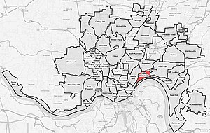
Columbia-Tusculum is the oldest neighborhood in Cincinnati, Ohio, and is located on the East Side of the city. The population was 1,523 at the 2020 census.

<span class="mw-page-title-main">Big Joe (bell)</span>

Joseph is a bronze bell that hangs 125 feet (38 m) into the bell tower of Neo-Gothic Saint Francis De Sales Catholic Church in Cincinnati, Ohio, United States. The endearing moniker Big Joe is a combination of the names of Joseph T. Buddeke, the largest donor of the project, and Big Ben, the great bell in the iconic Palace of Westminster clock tower in London.

<span class="mw-page-title-main">Avondale, Cincinnati</span> Neighborhood of Cincinnati in Hamilton, Ohio, United States

Avondale is a neighborhood in Cincinnati, Ohio. It is home to the Cincinnati Zoo and Botanical Garden. The population was 11,345 at the 2020 census.

<span class="mw-page-title-main">Carthage, Cincinnati</span> Neighborhood of Cincinnati in Hamilton, Ohio, United States

Carthage is a neighborhood located in the Mill Creek valley in Cincinnati, Ohio. Predominately residential, the neighborhood is a center of the city's Hispanic community. It shares a border with Elmwood Place, Ohio, which, with adjacent St. Bernard, Ohio, forms an enclave in the middle of Cincinnati. The population was 2,781 at the 2020 census.

<span class="mw-page-title-main">College Hill, Cincinnati</span> Neighborhood of Cincinnati in Hamilton, Ohio, United States

College Hill is a residential neighborhood of Cincinnati, Ohio. Originally a wealthy suburb called Pleasant Hill due to its prime location, it was renamed College Hill because of the two colleges that were established there in the mid-nineteenth century. The neighborhood is not to be confused with North College Hill, which borders College Hill to the north but is not part of Cincinnati. The population was 16,039 at the 2020 census.

<span class="mw-page-title-main">Cordova, Tennessee</span> Community in Tennessee, United States

Cordova is a community in Shelby County, Tennessee, United States. Cordova lies east of Memphis, north of Germantown, south of Bartlett, and northwest of Collierville at an elevation of 361 feet.

<span class="mw-page-title-main">Price Hill, Cincinnati</span> Neighborhoods of Cincinnati in Hamilton, Ohio, United States

Price Hill is a region of Cincinnati, Ohio consisting of three neighborhoods: East Price Hill, West Price Hill, and Lower Price Hill. The region is located in the western part of the city, neighbored by Sedamsville and Riverside to the south, Westwood and South Fairmount to the north, and Queensgate to the west. Originally one of the oldest suburbs of Cincinnati, the region is predominately Catholic, having been an ethnic enclave for both Irish and German Catholics. Price Hill's neighborhoods are residential communities, having a combined population of 36,271 at the 2020 census.

<span class="mw-page-title-main">CUF, Cincinnati</span> Neighborhood

CUF is a neighborhood in Cincinnati, Ohio. Its name is derived from the communities of Clifton Heights, University Heights, and Fairview. These communities surround the University of Cincinnati to the south and west of its main campus, making CUF a predominantly residential, student neighborhood. The population was 20,385 at the 2020 census.

<span class="mw-page-title-main">Corryville, Cincinnati</span> Neighborhood of Cincinnati in Ohio, United States

Corryville is a neighborhood in Cincinnati, Ohio, east of the University of Cincinnati, southeast of Clifton, south and west of Avondale, northwest of Walnut Hills, and north of Mount Auburn. The population was 4,373 at the 2020 census.

<span class="mw-page-title-main">East End, Cincinnati</span> Neighborhood of Cincinnati in Hamilton, Ohio, United States

East End is a neighborhood in Cincinnati, Ohio. The neighborhood, a 7-mile (11 km) strip along the Ohio River, once held Cincinnati's manufacturing district. It is the location of the Cincinnati Municipal Lunken Airport and Columbia Parkway. The population was 1,476 at the 2020 census.

<span class="mw-page-title-main">Walnut Hills, Cincinnati</span> Neighborhood of Cincinnati in Ohio, United States

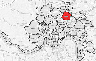
Walnut Hills is a neighborhood in Cincinnati, Ohio, United States. One of the city's oldest hilltop neighborhoods, it is a large diverse area on the near east side of Cincinnati. Eden Park is the gateway to Walnut Hills when driving north from downtown, and the University of Cincinnati is less than 10 minutes away. The neighborhood is redeveloping, restoring many of its buildings and introducing new businesses to the area. The population was 6,344 in the 2020 Census.

<span class="mw-page-title-main">Downtown Cincinnati</span> Neighborhood in Cincinnati, Ohio, United States

Downtown Cincinnati is the central business district of Cincinnati, Ohio, United States, as well the economic and symbiotic center of the Cincinnati metropolitan area. Originally the densely populated core of the city, the neighborhood was transformed into a commercial zone in the mid-20th century. The population was 5,835 at the 2020 census.

<span class="mw-page-title-main">Madison and Woodburn Historic District</span> Historic district in Ohio, United States

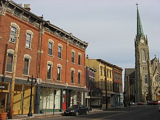
Madison and Woodburn Historic District is a registered historic district in Cincinnati, Ohio, listed in the National Register of Historic Places on June 30, 1983. It contains 19 contributing buildings.

References

  1. 1 2 3 4 5 "East Walnut Hills 2020 Statistical Neighborhood Approximation" (PDF). City of Cincinnati. Retrieved 18 December 2023.
  2. East Walnut Hills Assembly https://eastwalnuthills.org/history/
  3. Brent Coleman, Charles Dexter’s legacy: his home The Cincinnati Enquirer, January 9, 2014

39°7′30″N84°28′40″W / 39.12500°N 84.47778°W / 39.12500; -84.47778