
Shrewsbury Township is a township in York County, Pennsylvania, United States. The population was 6,447 at the 2010 census.
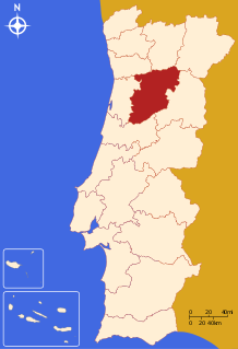
The District of Viseu is located in the Central Inland of Portugal, the District Capital is the city of Viseu.
The Hypocrite Channel is a small channel in Massachusetts Bay, located within the city limits of Boston. It's also located within the Boston Harbor Islands National Recreation Area. The channel runs between the islands of Half Tide Rocks, Calf Island, Little Calf Island, and Green Island.
Barrel Rock is a small barren rock within the edge of Cohasset Harbor in Cohasset, Massachusetts, USA. The rock is north of Sutton Rocks, northwest of Quarry Point, south of Chittenden Rock, and east of Brush Island. It is located at 42°15′32″N70°47′6″W

Dalton is an unincorporated census-designated place in the town of Kingston located in the southwestern corner of Green Lake County, Wisconsin, United States. It is located on Wisconsin Highway 44. It uses ZIP code 53926. As of the 2010 census, its population was 206. The surrounding countryside is mainly occupied by dairy farmers and an Amish community. Dalton has an area of 0.456 square miles (1.18 km2); 0.449 square miles (1.16 km2) of this is land, and 0.007 square miles (0.018 km2) is water. Dalton was named for John Dalton, who emigrated from Ireland with his family in the early 1850s.
Menemsha Hills is a protected nature reserve located on Martha's Vineyard, Massachusetts in the town of Chilmark. The property is owned by The Trustees of Reservations through three grants of land, the first in 1966.
Tudor and Cashel is a township in the Canadian province of Ontario, located in Hastings County.

Popcorn is an unincorporated community in Perry Township, Lawrence County, Indiana.
The Yakoun River is the largest river on Haida Gwaii, off the North Coast of British Columbia, Canada. Estimated to be 55 to 60 kilometres in length, it is located on Graham Island, the northernmost and largest of the archipelago, and runs in a twisting course generally northwards from Yakoun Lake, which lies near the island's south-central region, just northwards over Slatechuck Mountain from Skidegate Inlet, entering saltwater at Masset Inlet, a large saltwater bay located in the heart of the island.
Seth Demonstration Forest is a state forest in the state of Maryland.

The Misery Islands are an 87-acre (350,000 m2) nature reserve established in 1935 in Salem Sound close to the Salem Harbor in Salem, Massachusetts. It is managed by the Trustees of Reservations. The islands are a part of the city of Salem, although they are much closer to the city of Beverly, in whose aquatic territory they lie.

Cedar Grove is an unincorporated community in El Dorado County, California. It lies at an elevation of 3386 feet.
Berrytown is an unincorporated community in Rockingham County, Virginia, United States. Its elevation is 1,010 ft (308 m), and it is located at 38°22′06″N78°39′25″W.

The Crossways is a mixed-use residential/commercial complex in the west end of Toronto, Ontario, Canada, located at the intersection of Bloor Street West and Dundas Street West. It stretches across most of a city block.

The South Bend Train Wreck occurred on June 27, 1859, between Mishawaka and South Bend in Indiana on the Michigan Southern Railroad killing 42 people and injuring 50 more.
Mollendal is an uninhabited part of Virgin Islands National Park on the island of Saint John in the United States Virgin Islands. The L'Esperance Trail passes through this area.
Crease Island, formerly Lewis Island, is an island in the Broughton Archipelago Marine Provincial Park in the Queen Charlotte Strait-Johnstone Strait region of the Central Coast of British Columbia, Canada. It is located north of Harbledown Island and is at the southern extremity of the provincial park.
Five Points is an unincorporated community in Washington County, Florida, United States. It is located along State Road 280 north of Vernon. It primarily based on the Five Points Recreation Center.
Sammy Martinez is a census-designated place (CDP) in Starr County, Texas, United States. This was a new CDP for the 2010 census with a population of 110.
Des Moines Township is a township in Polk County, Iowa, USA.


