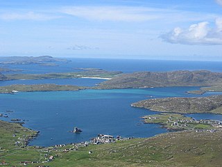
The Barra Isles, also known as the Bishop's Isles, are a small archipelago of islands in the Outer Hebrides of Scotland. They lie south of the island of Barra, for which they are named. The group consists of nine islands, and numerous rocks.
Long Beach, North Carolina is a coastal neighborhood that is incorporated into Oak Island, North Carolina in the year of 1955. Located on Oak Island, it is well known for the total devastation it sustained during Hurricane Hazel in 1954; only five of the 357 buildings survived the storm. It merged with neighboring Yaupon Beach in 1999 to form the town of Oak Island and is now a neighborhood of the town.
Bassetts Island is a propeller-shaped island within Pocasset Harbor and Red Brook Harbor, in Bourne, Massachusetts, USA.

111 South Wacker Drive is a high-rise office building located in Chicago, Illinois.. Completed in 2005 and standing at 681 feet, the 51 story blue-glass structure is one of the tallest in the city. It sits on the site of the former U.S. Gypsum Building, one of the tallest buildings in Chicago to be demolished.

Pasque Island is one of the Elizabeth Islands of Dukes County, Massachusetts, United States. It lies between Nashawena Island to the west and Naushon Island to the east. The island has a land area of 3.45 km² and had a population of 2 persons as of the 2000 census. The island is part of the town of Gosnold, Massachusetts.
Teotônio Vilela is a municipality located in the western of the Brazilian state of Alagoas. Its population was 41,403 (2005) and its area is 298 km².
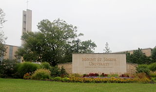
Mount Saint Joseph is an unincorporated community in central Delhi Township, Hamilton County, Ohio, United States. Although it is unincorporated, it has a post office, with the ZIP code of 45051. Because it includes the motherhouse of the Sisters of Charity of Cincinnati, the Internal Revenue Service recognizes 45051 as the eighth most generous ZIP code in the United States, with residents giving 41.50% of their net income to charity. The unincorporated community is also home to the Mount St. Joseph University.

Clark's Island is the name of a small island located in Duxbury Bay in the U.S. state of Massachusetts. It was named for John Clark, the first mate of the Mayflower, the ship that brought the Pilgrims to New England. The island was initially considered for the location of the Pilgrim's settlement, but was rejected in favor of a site to the south, which became known as Plymouth, Massachusetts. Today Clark's Island is a part of the town of Plymouth.

Hopeton is an unincorporated community in Accomack County, Virginia.

Digov is a village in the Lerik Rayon of Azerbaijan. The village forms part of the municipality of Mistan.
WRCI is a radio station owned by Impact Radio and licensed to Three Rivers, Michigan. It airs Westwood One's Classic Country format under the moniker River Country 97.1.

Thacher Island is a small island off Cape Ann on the Massachusetts coast in the United States. It is a part of the Town of Rockport. It was a place where some naval confrontations, both minor and major, took place, which helped secure a victory for the colonists.

Gorzyce Wielkie is a village in the administrative district of Gmina Ostrów Wielkopolski, within Ostrów Wielkopolski County, Greater Poland Voivodeship, in west-central Poland. It lies approximately 3 kilometres (2 mi) south-east of Ostrów Wielkopolski and 102 km (63 mi) south-east of the regional capital Poznań.
Stump Lake National Wildlife Refuge is a National Wildlife Refuge in Nelson County, North Dakota. It is managed under Devils Lake Wetland Management District.

The temperate rainforests of Admiralty Island's Kootznoowoo Wilderness are unique among the 5,700,000 acres (2,300,000 ha) of federally protected Wilderness in Southeast Alaska.
Salina Area Technical College (SATC) is a technical college located in Salina, Kansas. The school is coordinated by the Kansas Board of Regents and is regionally accredited by the Higher Learning Commission. The college has been in operation since 1965 and currently offers associate degrees, diplomas and certificates in several different programs.
Fort Nichols was a fort that existed in 1775 in Amesbury, Massachusetts. It was also known as Fort Merrimac during its existence. Two possible locations for the fort existed, although the coordinates lead to the one at a location named Salisbury Point on maps.
Camp Hobson was a military camp that existed during the Spanish–American War in 1898 in Gloucester, Massachusetts. It was located near the works known as Stage Fort, Fort Banks, Fort Cross, and Fort Allen during their intermittent use. Restored in 1930, it is now located on land belonging to Stage Fort Park.
Creston is an unincorporated community in Pennington County, in the U.S. state of South Dakota.
Centerville is an unincorporated community in Douglas County, in the U.S. state of Nevada.


