
Hull is a town in Plymouth County, Massachusetts, United States, located on a peninsula at the southern edge of Boston Harbor. Its population was 10,072 at the 2020 census. Hull is the smallest town by land area in Plymouth County and the fourth smallest in the state. However, its population density is nearly four times that of Massachusetts as a whole.
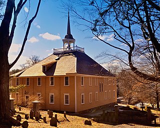
Hingham is a town in metropolitan Greater Boston on the South Shore of the U.S. state of Massachusetts in northern Plymouth County. At the 2020 census, the population was 24,284. Hingham is known for its colonial history and location on Boston Harbor. The town was named after Hingham, Norfolk, England, and was first settled by English colonists in 1633.
The Boston Harbor Islands National Recreation Area is a national recreation area situated among the islands of Boston Harbor of Boston, Massachusetts. The area is made up of a collection of islands, together with a former island and a peninsula, many of which are open for public recreation and some of which are very small and best suited for wildlife. The area is run by the Boston Harbor Islands Partnership. It includes the Boston Harbor Islands State Park, managed by the Commonwealth of Massachusetts. Twenty-one of the 34 islands in the area are also included in the Boston Harbor Islands Archeological District.

Boston Harbor is a natural harbor and estuary of Massachusetts Bay, and is located adjacent to the city of Boston, Massachusetts. It is home to the Port of Boston, a major shipping facility in the Northeastern United States.
World's End is a 251-acre (1 km²) park and conservation area located on a peninsula in Hingham, Massachusetts. The peninsula is bordered by the Weir River to the North and East and Hingham Harbor to the West. The land is composed of four drumlins harboring tree groves interspersed with fields attractive to butterflies and grassland-nesting birds, and offers 4.5 miles of walking paths with views of the Boston skyline.

Ragged Island is an island in the Hingham Bay area of the Boston Harbor Islands National Recreation Area, in the U.S. state of Massachusetts. The island has a permanent size of 4 acres (16,000 m2), and it is composed of Roxbury puddingstone which rises to a height of 30 feet (9.1 m) above sea level. Broken ledges surround most of the island with small gravel beaches on the southeast and northwest sides; there are also small tidal mudflats.
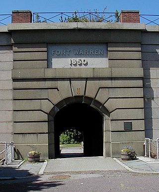
Fort Warren is a historic fort on the 28-acre (110,000 m2) Georges Island at the entrance to Boston Harbor. The fort is named for Revolutionary War hero Dr. Joseph Warren, who sent Paul Revere on his famous ride, and was later killed at the Battle of Bunker Hill. The name was transferred in 1833 from the first Fort Warren – built in 1808 – which was renamed Fort Winthrop.
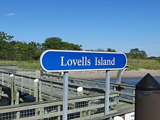
Lovells Island, or Lovell's Island, is a 62-acre (250,000 m2) island in the Boston Harbor Islands National Recreation Area, in Massachusetts. The island is across The Narrows from Georges Island and some 7 miles (11 km) offshore of downtown Boston. It is named after Captain William Lovell, who was an early settler of nearby Dorchester. The island is known as the site of several shipwrecks, including the 74-gun French warship Magnifique in 1782.

Bumpkin Island, also known as Round Island, Bomkin Island, Bumkin Island, or Ward's Island, is an island in the Hingham Bay area of the Boston Harbor. In 1902, Albert Burrage, a Boston philanthropist, had a summer hospital opened on the island for children with physical disabilities. During World War I the island was used by the U.S. Navy. Starting around 1940, the island was used as a facility for polio patients. However, the hospital closed during World War II and burned down in 1945. Since 1996, it is part of the Boston Harbor Islands National Recreation Area. The island has an area of 30 acres (120,000 m2), plus an intertidal zone of a further 31 acres (130,000 m2). It is composed of a central drumlin with an elevation of 70 feet (21 m) above sea level, surrounded by a rock-strewn shoreline. A sand spit, exposed at low tide, connects the eastern end of the island to Sunset Point in Hull.

Long Island is located in Boston Harbor, Massachusetts. The island is part of the City of Boston, and of the Boston Harbor Islands National Recreation Area. The island is 1.75 miles (2.82 km) long and covers 225 acres (0.9 km2).

Webb Memorial State Park is a public recreation area located on a peninsula that extends nearly half a mile into the Hingham Bay area of Boston Harbor in Massachusetts. It is composed of three connected drumlins and a low marsh area. The state park forms the only mainland portion of the Boston Harbor Islands National Recreation Area.
Fort Banks was a U.S. Coast Artillery fort located in Winthrop, Massachusetts. It served to defend Boston Harbor from enemy attack from the sea and was built in the 1809 during what is known as the Endicott period, a time in which the coast defenses of the United States were seriously expanded and upgraded with new technology. Today, the fort's mortar battery is on the National Register of Historic Places.

Fort Heath was a US seacoast military installation for defense of the Boston and Winthrop Harbors with an early 20th-century Coast Artillery fort, a 1930s USCG radio station, prewar naval research facilities, World War II batteries, and a Cold War radar station. The fort was part of the Harbor Defenses of Boston and was garrisoned by the United States Army Coast Artillery Corps. The fort's military structures have been replaced by a residential complex, including the luxurious Forth Heath Apartments, and recreation facilities of Small Park, which has both a commemorative wall and an historical marker for Fort Heath.

Fort Duvall was a Coast Artillery fort, part of the Harbor Defenses of Boston, in Massachusetts. What was then called Hog Island in Hull, Massachusetts was acquired by the U.S. government in 1917, and the fort was constructed in the early 1920s. It had only one gun battery, Battery Long, but it mounted the largest caliber weapons in the entire harbor defense system: a pair of 16-inch guns. These were the 16-inch gun M1919, of which only seven were deployed; 16-inch weapons deployed later were supplied by the Navy.

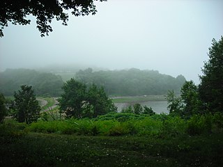
Hingham Bay is the easternmost of the three small bays of outer Boston Harbor, part of Massachusetts Bay and forming the western shoreline of the town of Hull and the northern shoreline of Hingham in the United States state of Massachusetts. It lies east of Quincy Bay and is met at the southwest by the mouth of Weymouth Fore River, also forming part of the waterfront of Weymouth. The bay is home to several of the Boston Harbor Islands.

Weir River is a short stream and estuary that empties into Hingham Bay, part of Boston Harbor in Massachusetts, United States. The name is attributed to the location of a fishing weir in the stream. The river gives its name to a larger watershed and Weir River Farm, a park and nature reserve owned by The Trustees of Reservations.

Fort Revere is an 8-acre (3.2 ha) historic site situated on a small peninsula located in Hull, Massachusetts. It is situated on Telegraph Hill in Hull Village and contains the remains of two seacoast fortifications, one from the American Revolution and one that served 1898–1947. There are also a water tower with an observation deck, a military history museum and picnic facilities. It is operated as Fort Revere Park by the Metropolitan Park System of Greater Boston.

The Fort Heath radar station was a USAF radar site and US Army Missile Master installation of the joint-use site system (JUSS) for North American Air Defense at a former coastal defense site. The Cold War radar station had 2 USAF AN/FPS-6B height finding radars, 2 Army AN/FPS-6A height finders, an FAA ARSR-1 radar emplaced 1958-9, and an Army nuclear bunker. Arctic Towers were the pedestals for the FPS antennas and radomes, while the Air Route Surveillance Radar was on a 50-foot extension temperate tower adjacent to the Federal Aviation Administration building.

The Harbor Defenses of Boston was a United States Army Coast Artillery Corps harbor defense command. It coordinated the coast defenses of Boston, Massachusetts from 1895 to 1950, beginning with the Endicott program. These included both coast artillery forts and underwater minefields. The command originated circa 1895 as the Boston Artillery District, was renamed Coast Defenses of Boston in 1913, and again renamed Harbor Defenses of Boston in 1925.
