Related Research Articles

Pembrokeshire is a county in the south-west of Wales. It is bordered by Carmarthenshire to the east, Ceredigion to the northeast, and otherwise by the sea. Haverfordwest is the largest town and administrative headquarters of Pembrokeshire County Council.

Strumble Head is a rocky headland in the community of Pencaer in Pembrokeshire, Wales, within the Pembrokeshire Coast National Park. It marks the southern limit of Cardigan Bay. Three islands lie off the head: Ynys Meicel – 112 feet (34 m) – Ynys Onnen and Carreg Onnen.

The Bishops and Clerks are a group of rocks and islets, approximately 1+1⁄2 miles (2.4 km) west of Ramsey Island, Pembrokeshire, Wales.

Moelfre ( ) is a village, a community and, until 2012, an electoral ward on the north-east coast of the Isle of Anglesey in Wales. The community area covers the village and harbour, and several smaller, dispersed settlements. It includes six scheduled Iron Age hut groups and many other sites of archaeological interest. The harbour was formerly a local fishing port; a lifeboat station has been based here since 1854. Among many shipwrecks off the coast was that of the Royal Charter in 1859. Near the modernised lifeboat station is the RNLI Seawatch Centre. The coastline includes a rocky headland north of the village and a large sandy beach at Lligwy Bay, both traversed by the Anglesey Coastal Path. The 2011 census measured the village population as 710. It was estimated at 614 in 2019.

Waterston is a village near Milford Haven in Pembrokeshire, Wales, in the community and parish of Llanstadwell. It lies on the B4325 road linking Neyland and Milford Haven.

Penally is a coastal village, parish and community 1 mile (1.6 km) southwest of Tenby in Pembrokeshire, Wales. The village is known for its Celtic Cross, Penally Abbey, the neighbouring St. Deiniol's Well, WWI Practice trenches, and Penally Training Camp. In the community, though nearer to St Florence than Penally, is Carswell Medieval House, a Grade II* listed building.
HMY Mary was the first Royal Yacht of the Royal Navy. She was built in 1660 by the Dutch East India Company. Then she was purchased by the City of Amsterdam and given to King Charles II, on the restoration of the monarchy, as part of the Dutch Gift. She struck rocks off Anglesey in thick fog on 25 March 1675 while en route from Dublin to Chester. Although 35 of the 74 crew and passengers were killed as the wreck quickly broke up, 39 managed to get to safety. The remains were independently discovered by two different diving groups in July 1971. After looters started to remove guns from the site, a rescue operation was organized and the remaining guns and other artifacts were taken to the Merseyside Museums for conservation and display. After the passing of the Protection of Wrecks Act 1973, she was designated as a protected site on 20 January 1974.

The Diocese of St Davids is a diocese of the Church in Wales, a church of the Anglican Communion. The diocese covers the historic extent of Ceredigion, Carmarthenshire and Pembrokeshire, together with a small part of western Glamorgan. The episcopal see is the Cathedral Church of St David in the City of St Davids, Pembrokeshire. The present cathedral, which was begun in 1181, stands on the site of a monastery founded in the 6th century by Saint David.
Solva is a village, community and electoral ward in Pembrokeshire, Wales. The village comprises principally Lower Solva and Upper Solva. The community also includes Middle Mill and Whitchurch.

Nash Point is a headland and beach in the Monknash Coast of the Vale of Glamorgan in south Wales, about a mile from Marcross. It is a popular location for ramblers and hiking along the cliffs to Llantwit Major beach. The lighthouse meadow is a Site of Special Scientific Interest, containing rare plants such as the tuberous thistle, and other wildlife such as choughs can be seen.
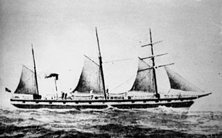
SS Gothenburg was an iron-hulled sail- and steamship that was built in England in 1854 and sailed between England and Sweden until 1862. She then moved to Australia, where she operated across the Tasman Sea to and from New Zealand until 1873, when she was rebuilt. After her rebuild, she operated in the Australian coastal trade.

Jack Sound is a treacherous body of water between the island of Skomer and the Pembrokeshire coast in west Wales. It is popular with divers.

Thorne Island is a rocky islet and part of the community of Angle, Pembrokeshire, Wales, with an area of 2 acres (8,100 m2), dominated by a coastal artillery fort built to defend the Milford Haven Waterway in the mid-19th century. It has been the site of a number of shipwrecks, including one in 1894 that was carrying a cargo of Scotch whisky.

The Adolphe was a sailing ship that was wrecked at the mouth of the Hunter River in New South Wales, Australia, in 1904. The ship is now the most prominent of several wrecks on what is now the Stockton breakwall, which protects Newcastle harbour. The rescue of the ship's crew has gone down in local maritime history as one of the most remarkable in local waters.

Roch Castle is a 12th-century castle, located at Roch near Haverfordwest, Wales.
Llanfaethlu is a village and community in the north west of Anglesey, in north-west Wales. The community population taken at the 2011 Census was 553. The village takes its name from the Church of Saint Maethlu. The community includes Llanfwrog.
Calburga was a Canadian barque, the last Canadian-built square-rigger of large tonnage. She was built in 1890 at South Maitland, Nova Scotia by local shipbuilder, Adams MacDougall. Calburga was a spruce built vessel, iron and copper fastened, and equipped with three masts. Calburga boasted luxuries such as a windmill pump installed in 1913 to keep free of water, a wheelhouse completely enclosing the helmsman and wheel gear, round and elliptical stems, and an exterior ornamented by hand-carved scrolling.
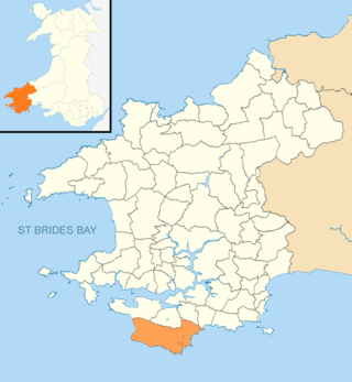
Stackpole and Castlemartin is a community in Pembrokeshire, Wales, 4 miles (6.4 km) south of Pembroke.
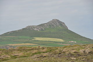
Carn Llidi is a hill east of St David's Head in Pembrokeshire, Wales. Carn Llidi and its surrounding area is part of the Pembrokeshire Coast National Park.
References
- ↑ "Visit Pembrokeshire: Scuba Diving" . Retrieved 4 August 2024.
- ↑ Sailing directions for the British channel. Edward James Bedford. p. 58 . Retrieved 20 November 2018.
Crow Rock Linney Head.
- ↑ Ordnance Survey
- ↑ "Coflein: Crow Rock" . Retrieved 4 August 2024.
- ↑ "Balholm (240969)". Coflein. RCAHMW . Retrieved 3 August 2024.
- ↑ "Berkeley Castle (273336)". Coflein. RCAHMW . Retrieved 3 August 2024.
- ↑ "Elizabeth and Hannah (272783)". Coflein. RCAHMW . Retrieved 3 August 2024.
- ↑ "Catherine (272945)". Coflein. RCAHMW . Retrieved 3 August 2024.
- ↑ "Amelia (240332)". Coflein. RCAHMW . Retrieved 3 August 2024.
- ↑ "Tormes (273091)". Coflein. RCAHMW . Retrieved 3 August 2024.
- ↑ "Seasearch Wales 2016 Summary Report" (PDF). pp. 3, 9. Retrieved 5 August 2024.
- ↑ "Seasearch South and West Wales 2019 Summary Report" (PDF). p. 22. Retrieved 5 August 2024.
51°36′43″N5°03′18″W / 51.612°N 5.055°W
