Spittal is both a village, a parish and a community in Pembrokeshire, Wales, on the A40 trunk road, approximately halfway between Haverfordwest and Fishguard.

St Dogmaels is a village, parish and community in Pembrokeshire, Wales, on the estuary of the River Teifi, a mile downstream from the town of Cardigan in neighbouring Ceredigion. A little to the north of the village, further along the estuary, lies Poppit Sands beach. The parish includes the small settlement of Cippyn, south of Cemaes Head.

Saundersfoot is a large village, community and electoral ward in Pembrokeshire, Wales. It is near Tenby, both being holiday destinations. Saundersfoot lies in the Pembrokeshire Coast National Park and on the Pembrokeshire Coast Path. The village population was 3,361 in 2011.

Moylgrove, also spelled Moylegrove, is a village and parish in north Pembrokeshire, Wales, about 4 miles (6.4 km) from Cardigan, in the community of Nevern.

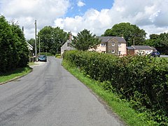
Burton is a small village, parish and community in Pembrokeshire, Wales, set on a hill overlooking the River Cleddau with views of the estuary to the south, east and west. The community includes the village of Hill Mountain.

Carew is a village, parish and community on an inlet of Milford Haven in the former Hundred of Narberth, Pembrokeshire, West Wales, 4 miles (6.4 km) east of Pembroke. The eastern part of the parish is in the Pembrokeshire Coast National Park.

Freshwater East is a village in Pembrokeshire, Wales. The majority of the village is on a cliff overlooking a bay. It is approximately 7 miles (11 km) from Pembroke by road, and 2 miles (3.2 km) south of Lamphey, and is in the parish and community of Lamphey. Freshwater East is the site of a Green Coast Award Beach.

Reynalton is a small village and parish in Pembrokeshire, Wales, near Tenby and Kilgetty, and is in Kilgetty/Begelly community.
Solva is a village, community and electoral ward in Pembrokeshire, Wales. The village comprises principally Lower Solva and Upper Solva. The community also includes Middle Mill and Whitchurch.

Mathry is a village, community and parish in Pembrokeshire, Wales. The hilltop village is 6 miles (9.7 km) southwest of Fishguard, close to the A487 road between Fishguard and St David's.

Llangwm is a small village, parish and community of around 450 properties situated on the Llangwm Pill off the River Cleddau estuary near Haverfordwest, Pembrokeshire, Wales. It has a history of mining and fishing and is in the largely English-speaking south of the county.
Llanwnda is a rural village and parish to the north of the Welsh county of Pembrokeshire and part of the community of Pencaer. It lies some two miles northwest of the port of Fishguard and is inside the boundaries of the Pembrokeshire Coast National Park.
Castlemartin is a village and parish in the community of Stackpole and Castlemartin, Pembrokeshire, Wales, in the Pembrokeshire Coast National Park.

Gumfreston is a parish and small village 1 mile (1.6 km) from St. Florence and 2 miles (3.2 km) from Tenby, south Pembrokeshire, Wales. It is in the community of St. Mary Out Liberty. The B4318 is the main road that passes through Gumfreston.

Jeffreyston is a village, parish and community in Pembrokeshire.

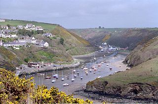
Lawrenny is a village and parish in the community and electoral ward of Martletwy, in the county of Pembrokeshire, Wales. It is on a peninsula of the River Cleddau estuary upriver from Milford Haven where it branches off towards the Cresswell and Carew Rivers and is in the Pembrokeshire Coast National Park.

Rudbaxton is a village, parish and a local government community in the county of Pembrokeshire, Wales. It is 81 miles (130 km) from Cardiff and 208 miles (335 km) from London.
Tavernspite is a small village about 6 miles (9.7 km) southeast of Narberth in Pembrokeshire, southwest Wales. It lies on the B4314 Pendine to Templeton road, close to the border with Carmarthenshire and is in Lampeter Velfrey community and parish. It is a historical meeting point of several roads. The population at the 2011 census was 349.
Hill Mountain is a village in the community and parish of Burton, south Pembrokeshire, Wales. The population in 2011 was 673.