Dale, The Dale, Dales or The Dales may refer to:

Pembrokeshire is a county in the south-west of Wales. It is bordered by Carmarthenshire to the east, Ceredigion to the northeast, and is otherwise surrounded by the sea. Haverfordwest is the largest town and administrative headquarters of Pembrokeshire County Council.

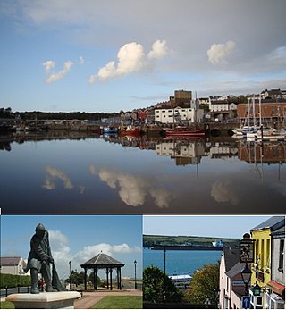
Haverfordwest is the county town of Pembrokeshire, Wales, and the most populous urban area in Pembrokeshire with a population of 14,596 in 2011. It is also a community, being the second most populous community in the county, with 12,042 people, after Milford Haven. The suburbs include the former parish of Prendergast, Albert Town and the residential and industrial areas of Withybush.
Milford Haven is both a town and a community in Pembrokeshire, Wales. It is situated on the north side of the Milford Haven Waterway, an estuary forming a natural harbour that has been used as a port since the Middle Ages.

Tenby is a seaside town and community in the county of Pembrokeshire, Wales. It lies within Carmarthen Bay.

Pembroke Dock is a town and a community in Pembrokeshire, South West Wales, 3 miles (4.8 km) northwest of Pembroke on the banks of the River Cleddau. Originally Paterchurch, a small fishing village, Pembroke Dock town expanded rapidly following the construction of the Royal Navy Dockyard in 1814. The Cleddau Bridge links Pembroke Dock with Neyland.

Marloes is a village and parish in Pembrokeshire, Wales, on the Marloes Peninsula 7 miles (11 km) west of Milford Haven and forms the western tip of the southern shore of St Brides Bay. It is within part of the Pembrokeshire Coast National Park. The parish has 6 miles (9.7 km) of mainland coastline accessible throughout by the Pembrokeshire Coast Path and, together with St Brides, constitutes the community of Marloes and St Brides. In 2001, the population was 323.

Milford Haven Waterway is a natural harbour in Pembrokeshire, Wales. It is a ria or drowned valley which was flooded at the end of the last ice age. The Daugleddau estuary winds west to the sea. As one of the deepest natural harbours in the world, it is a busy shipping channel, trafficked by ferries from Pembroke Dock to Ireland, oil tankers and pleasure craft. Admiral Horatio Nelson, visiting the haven with the Hamiltons, described it as the next best natural harbour to Trincomalee in Ceylon and "the finest port in Christendom". Much of the coastline of the Waterway is designated as a Site of Special Scientific Interest, listed as Milford Haven Waterway SSSI.

Angle is a village, parish and community on the southern side of the entrance to the Milford Haven Waterway in Pembrokeshire, Wales. The village school has closed, as has the village shop. There is a bus link to Pembroke railway station.
Rosemarket is a village, parish and community in Pembrokeshire, Wales, north of Milford Haven.
St Ishmaels or St Ishmael's is a village, parish and community close to the Milford Haven Waterway in Pembrokeshire, Wales. The community comprises most of the parish of St Ishmaels and had a population of 478 at the 2011 census. The ward includes the communities of Herbrandston, Dale and Marloes and St. Brides. The community was subsequently merged with other communities and only the ward remained with the name St Ishmael's. This covers the entire peninsula with at total population at the 2011 census of 1,405.
Royal Air Force Angle or more commonly RAF Angle, is a former Royal Air Force station located on the Angle Peninsula Coast, 8 miles (13 km) west of Pembroke, Pembrokeshire, Wales. It was operational from 1 June 1941 to 11 July 1946, having been used by both the Royal Air Force and the Royal Navy.

Royal Naval Air Station Dale is a former Royal Naval Air Station, located 10 miles (16 km) South West of Haverfordwest in Pembrokeshire, Wales. It was operational between 1942 and 1948, being used by both the Royal Air Force (1942–1943) and the Royal Navy (1943–1948).
The town of Milford Haven was founded in 1793 by Sir William Hamilton, who initially invited Quaker whalers from Nantucket to live in his town, and then, in 1797, the Navy Board to create a dockyard for building warships.

Chapel Bay Fort is located on the southern shore of the Milford Haven Waterway, Pembrokeshire, Wales. The fort is approximately 1 mile (1.6 km) from the village of Angle. One of a series of forts built as part of the inner line of defence of the Haven following the Royal Commission on the Defence of the United Kingdom, it is a Grade II Listed Building. and is also known as "Chapel Bay Battery".
A number of shore establishments of the Royal Navy, used by the Fleet Air Arm, have borne the name HMS Goldcrest

West Blockhouse Fort is a mid-19th century coastal artillery fort at West Blockhouse Point, a rocky headland near Dale, Pembrokeshire, to the west of Milford Haven in Wales.
The Pembrokeshire League is a football league in Pembrokeshire, West Wales, running from levels five to nine of the Welsh football league system.
The Pembrokeshire Senior Cup is a football knockout tournament involving teams from in Pembrokeshire, West Wales who play in leagues administered and associated with the Pembrokeshire Association Football League.

HMS Harrier was a shore establishment of the Royal Navy, located at Kete, Pembrokeshire. It was commissioned on 1 February 1948 and was the home of the RN School of Aircraft Direction from the end of the Second World War, opened on 1 January 1945, until 1961, when the Aircraft Direction Officer Training returned to RNAS Yeovilton. The site at Kete was ideal for air interception exercises, with the centre located 1 mile South of RNAS Dale, from where the live interception flights were provided from, and it had a wide sector over the sea.


