St Davids and the Cathedral Close

Last updated

St Davids and the Cathedral Close
City and Community
Porthstinian - geograph.org.uk - 478476.jpg
Typical community coastline at Porthstinian
St Davids and the Cathedral Close
Pembrokeshire UK location map.svg
Red pog.svg
St Davids and the Cathedral Close
Location within Pembrokeshire
Area17.93 sq mi (46.4 km2)
Population1,751 (2021)
  Density 98/sq mi (38/km2)
OS grid reference SM7425
  Cardiff 90 mi (140 km)  ESE
  London 220 mi (350 km)  ESE
Principal area
Preserved county
Country Wales
Sovereign state United Kingdom
Places St Davids, St Justinians, Caerfarchell, St Davids Head, Whitesands Bay, Ramsey Island
Post town HAVERFORDWEST
Postcode district SA62
Dialling code 01437
Police Dyfed-Powys
Fire Mid and West Wales
Ambulance Welsh
UK Parliament
Senedd Cymru – Welsh Parliament
Website www.stdavids.gov.uk
List of places
UK
Wales
Pembrokeshire
51°52′55″N5°16′08″W / 51.882°N 5.269°W / 51.882; -5.269

St Davids and the Cathedral Close is a community in western Pembrokeshire, Wales. It comprises the city of St Davids and its surrounding rural area. [1] It was established in 1987.

Contents

Geography

The community occupies the northwestern tip of Pembrokeshire (including the westernmost point of Wales), in the Pembrokeshire Coast National Park, and includes a number of small settlements as well as the city of St Davids. The A487 road runs through it, as do a number of minor roads. Much of the community is elevated agricultural land and rocky coastline. Ramsey Island is part of the community. [2] [1]

At the 2001 census, the population of the community was 1,797. In 2011, this had risen to 1,841, [3] and fell to 1,751 at the 2021 census. [4]

There are several isolated hamlets in the community:

Several islands and islets lie within a few miles from the coast. These are administratively within St Davids:

The islands below are part of the Bishop And Clerks grouping, and were included in 1987: [6]

Governance

The community was established in 1974 as the community of St Davids; under The Preseli (Communities) Order 1987 it was given its present name. [7]

St Davids City Council is the community council body, and has twelve councillors. The Council employs a City Clerk and a Financial Officer. [8] The council is responsible for a wide range of public services and facilities, including providing links to Pembrokeshire County Council and Pembrokeshire Coast National Park Authority. [9] [10]

Following a public consultation, in March 2004 the community, in conjunction with the Pembrokeshire Local Action Network for Enterprise and Development (PLANED), published an action plan, covering:

The aim was "to encourage both local residents, potential partners and funders to realise the benefits that the proposals can bring to the community and assist in achieving them". Similar community appraisals had taken place in 1988, 1995 and 2003. [2]

Listed buildings

There are 211 listed buildings in the community, many of which are in the city of St Davids itself, but they also include some structures in the surrounding rural area, such as the present and past lifeboat stations and the ruined chapel at St Justinians. [11]

Worship

Along with St Davids Cathedral, there are numerous places of worship in the community, many scattered in the rural area surrounding the city. They include Baptist, Welsh Baptist, Congregational, Calvinistic Methodist and Independent; some are no longer active. Many of their records have been preserved by Dyfed Family History Society. [12]

Related Research Articles

<span class="mw-page-title-main">Fishguard</span> Town in Pembrokeshire, Wales

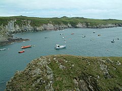
Fishguard is a coastal town in Pembrokeshire, Wales, with a population of 3,419 in 2011; the community of Fishguard and Goodwick had a population of 5,407. Modern Fishguard consists of two parts, Lower Fishguard and the "Main Town". Fishguard and Goodwick are twin towns with a joint Town Council.

<span class="mw-page-title-main">St Davids</span> Cathedral city in Pembrokeshire, Wales

St Davids or St David's is a cathedral city in Pembrokeshire, Wales. It lies on the River Alun and is part of the community of St Davids and the Cathedral Close. It is the resting place of Saint David, Wales's patron saint, and named after him.

<span class="mw-page-title-main">Goodwick</span> Town on Fishguard Harbour, Wales

Goodwick is a coastal town in Pembrokeshire, Wales, immediately west of its twin town of Fishguard.

<span class="mw-page-title-main">Pembrokeshire Coast National Park</span> National park in Wales

Pembrokeshire Coast National Park is a national park along the Pembrokeshire coast in west Wales.

<span class="mw-page-title-main">Ramsey Island</span> Island in Pembrokeshire, Wales

Ramsey Island is an island about 1 kilometre off St David's Head in Pembrokeshire on the northern side of St Brides Bay, in southwest Wales, in the community of St Davids and the Cathedral Close. It is 259 hectares in area. Ramsey means Hrafn's island.

<span class="mw-page-title-main">Preseli Mountains</span> Hill range in Wales

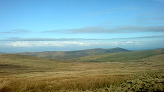
The Preseli Mountains, also known as the Preseli Hills, or just the Preselis, is a range of hills in western Wales, mostly within the Pembrokeshire Coast National Park and entirely within the county of Pembrokeshire.

<span class="mw-page-title-main">Tidal island</span> Island accessible by foot at low tide

A tidal island is a raised area of land within a waterbody, which is connected to the larger mainland by a natural isthmus or man-made causeway that is exposed at low tide and submerged at high tide, causing the land to switch between being a promontory/peninsula and an island depending on tidal conditions.

<span class="mw-page-title-main">Strumble Head</span>

Strumble Head is a rocky headland in the community of Pencaer in Pembrokeshire, Wales, within the Pembrokeshire Coast National Park. It marks the southern limit of Cardigan Bay. Three islands lie off the head: Ynys Meicel – 112 feet (34 m) – Ynys Onnen and Carreg Onnen.

<span class="mw-page-title-main">Mynachlog-ddu</span> Human settlement in Wales

Mynachlog-ddu is a village, parish and community in the Preseli Hills, Pembrokeshire, Wales. The community includes the parish of Llangolman.

Ynys Bery is a small island south of Ramsey Island, Pembrokeshire, Wales, in the community of St David's and the Cathedral Close.

<span class="mw-page-title-main">Bishops and Clerks</span>

The Bishops and Clerks are a group of rocks and islets, approximately 1+12 miles (2.4 km) west of Ramsey Island, Pembrokeshire, Wales.

<span class="mw-page-title-main">Dinas Cross</span> Human settlement in Wales

Dinas Cross is a village, a community and a former parish in Pembrokeshire, Wales. Located between Fishguard and Newport in the Pembrokeshire Coast National Park, it is a popular holiday destination on the A487 road. The two hamlets, Cwm-yr-Eglwys and Pwllgwaelod, are in the community. The community has an elected community council and until 2022 gave its name to an electoral ward of Pembrokeshire County Council which covered the communities of Dinas Cross, Cwm Gwaun and Puncheston.

<span class="mw-page-title-main">Rhoscolyn</span> Village in Anglesey, in north-west Wales

Rhoscolyn is a village and community located on Holy Island, Anglesey, Wales. It is just over five miles south of Holyhead and is the most southerly settlement on the island. The name Rhoscolyn is said to mean "The Moor" (Rhos) of The Column (colyn), referring to a pillar which the Romans put up to mark the edge of their territories. The community population taken from the 2011 census was 542.

Maenclochog is a village, parish and community in Pembrokeshire, south-west Wales. It is also the name of an electoral ward comprising a wider area of four surrounding communities. Maenclochog Community includes the small settlement of Llanycefn and the village of Rosebush.

<span class="mw-page-title-main">Pencaer</span>

Pencaer is a community which covers an area of dispersed settlement in Pembrokeshire, Wales, on the peninsula of Pen Caer and comprises the village of Llanwnda and the smaller settlements of Granston, Llangloffan, St Nicholas (Tremarchog) and Trefasser. The population of the community taken at the 2011 census was 474.

<span class="mw-page-title-main">Llanrhian</span> Human settlement in Wales

Llanrhian is a small village, community and parish in Pembrokeshire in west Wales, near the coast, south of Porthgain village. The community of Llanrhian includes the settlements of Llanhowell, Croesgoch, Portheiddy, Porthgain and Trefin. The village church is St Rhian’s and is of medieval origin. The village is in the Pembrokeshire Coast National Park.

<span class="mw-page-title-main">St Justinian</span> Place in Pembrokeshire, Wales

St Justinian is a coastal location of indeterminate area in the extreme northwest of Pembrokeshire, Wales, in the community of St Davids and the Cathedral Close.

The geology of Pembrokeshire in Wales inevitably includes the geology of the Pembrokeshire Coast National Park which extends around the larger part of the county's coastline and where the majority of rock outcrops are to be seen. Pembrokeshire's bedrock geology is largely formed from a sequence of sedimentary and igneous rocks originating during the late Precambrian and the Palaeozoic era, namely the Ediacaran, Cambrian, Ordovician, Silurian, Devonian and Carboniferous periods, i.e. between 635 and 299 Ma. The older rocks in the north of the county display patterns of faulting and folding associated with the Caledonian Orogeny. On the other hand, the late Palaeozoic rocks to the south owe their fold patterns and deformation to the later Variscan Orogeny.

References

  1. 1 2 Ordnance Survey
  2. 1 2 "St Davids Action Plan 2004" (PDF). Retrieved 26 February 2021.
  3. Office for National Statistics
  4. UK Census (2021). "2021 Census Area Profile – St. David's and the Cathedral community (W04000466)". Nomis. Office for National Statistics . Retrieved 23 February 2024.
  5. "RCAHMW: Historic place names: Vachelich" . Retrieved 18 June 2020.
  6. "The Preseli (Communities) Order 1987". legislation.gov.uk. Archived from the original on 10 September 2018. Retrieved 9 September 2018. Communities (6) the Bishops and Clerks shall be included in the new community of St. Davids and the Cathedral Close
  7. "The Preseli (Communities) Order 1987" . Retrieved 25 February 2021.
  8. "St Davids City Council". St Davids. Retrieved 25 February 2021.
  9. "St Davids City Council: Community information" . Retrieved 25 February 2021.
  10. "St Davids City Council: Home page" . Retrieved 25 February 2021.
  11. "British Listed Buildings: St David's and the Cathedral Close" . Retrieved 25 February 2021.
  12. "GENUKI: St David's" . Retrieved 25 February 2021.