
Pembrokeshire is a county in the south-west of Wales. It is bordered by Carmarthenshire to the east, Ceredigion to the northeast, and is otherwise surrounded by the sea. Haverfordwest is the largest town and administrative headquarters of Pembrokeshire County Council.

Haverfordwest is the county town of Pembrokeshire, Wales, and the most populous urban area in Pembrokeshire with a population of 14,596 in 2011. It is also a community, being the second most populous community in the county, with 12,042 people, after Milford Haven. The suburbs include the former parish of Prendergast, Albert Town and the residential and industrial areas of Withybush.

Cilgerran is both a village, a parish, and also a community, situated on the south bank of the River Teifi in Pembrokeshire, Wales. It was formerly an incorporated market town.

Nevern is both a parish and a community in Pembrokeshire, Wales. The community includes the settlements of Felindre Farchog, Monington, Moylgrove and Bayvil. The small village lies in the Nevern valley near the Preseli Hills of the Pembrokeshire Coast National Park 2 miles (3 km) east of Newport on the B4582 road.

Wolfscastle, also spelt Wolf's Castle, is a village and community in Pembrokeshire, between Haverfordwest and Fishguard, in southwest Wales. It was historically in the parish of St Dogwells.

Dale is both a small village and a community in Pembrokeshire, Wales, located on the peninsula which forms the northern side of the entrance to the Milford Haven Waterway. The village has 205 inhabitants according to the 2001 census, increasing to 225 at the 2011 Census.

St Dogmaels is a village, parish and community in Pembrokeshire, Wales, on the estuary of the River Teifi, a mile downstream from the town of Cardigan in neighbouring Ceredigion. A little to the north of the village, further along the estuary, lies Poppit Sands beach. The parish includes the small settlement of Cippyn, south of Cemaes Head.

Pyle is a village and community in Bridgend county borough, Wales. This large village is served by the A48 road, and lies less than one mile from Junction 37 of the M4 motorway, and is therefore only a half-hour journey from the capital city of Wales, Cardiff. The nearest town is the seaside resort of Porthcawl. Within the Community, to the northeast of Pyle, is the adjoining settlement of Kenfig Hill, North Cornelly also adjoins Pyle and the built-up area had a population of 13,701 in 2011.

Saundersfoot is a large village and community in Pembrokeshire, Wales. It is near Tenby, both being holiday destinations. Saundersfoot lies in the Pembrokeshire Coast National Park and on the Pembrokeshire Coast Path. The village population was 3,361 in 2011. while the community had a population of 2,628.
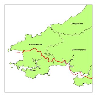
The Landsker Line is a term used for the language border in Wales between the largely Welsh-speaking and largely English-speaking areas in Pembrokeshire and Carmarthenshire. The English-speaking areas, south of the Landsker line and known as Little England beyond Wales, are notable for having been English linguistically and culturally for many centuries despite being far from the England–Wales border.

Picton Castle is a medieval castle near Haverfordwest in the community of Uzmaston, Boulston and Slebech, Pembrokeshire, Wales. Originally built at the end of the 13th century by a Flemish knight, it later came into the hands of Sir John Wogan. The castle and estate are now run by the Picton Castle Trust, a registered charity, and are no longer occupied by Wogan's descendants, the Philipps family. It is of unusual construction and has been remodelled several times during its history. The castle is a Grade I listed building and its gardens and park are designated at Grade II* on the Cadw/ICOMOS Register of Parks and Gardens of Special Historic Interest in Wales.

Walton East is a small rural village and parish established around a church at least as early as Norman times. It is 2 miles (3.2 km) southwest of Llys y Fran and 1+1⁄2 miles (2.4 km) north of Clarbeston Road and in Wiston community in Pembrokeshire, Wales.

Carew is a village, parish and community on an inlet of Milford Haven in the former Hundred of Narberth, Pembrokeshire, West Wales, 4 miles (6.4 km) east of Pembroke. The eastern part of the parish is in the Pembrokeshire Coast National Park.
Rosemarket is a village, parish and community in Pembrokeshire, Wales, north of Milford Haven.

Llangwm is a small village, parish and community of around 450 properties situated on the Llangwm Pill off the River Cleddau estuary near Haverfordwest, Pembrokeshire, Wales. It has a history of mining and fishing and is in the largely English-speaking south of the county.

The Hundred of Dungleddy was a hundred in the centre of Pembrokeshire, Wales. It had its origins in the pre-Norman cantref of Deugleddyf. It derives its Welsh name from its position between the two branches of the River Cleddau (Cleddyf): the English form is a corruption of the Welsh. The area of the cantref was around 185 km2: it was the smallest of the seven cantrefi of Dyfed.
Maenclochog is a village, parish and community in Pembrokeshire, south-west Wales. It is also the name of an electoral ward comprising a wider area of four surrounding communities. Maenclochog Community includes the small settlement of Llanycefn and the village of Rosebush.
St Ishmaels or St Ishmael's is a village, parish and community close to the Milford Haven Waterway in Pembrokeshire, Wales. The community comprises most of the parish of St Ishmaels and had a population of 478 at the 2011 census. The ward includes the communities of Herbrandston, Dale and Marloes and St. Brides. The community was subsequently merged with other communities and only the ward remained with the name St Ishmael's. This covers the entire peninsula with a total population at the 2011 census of 1,405.

Ambleston is a village, parish, and community in Pembrokeshire, Wales, lying seven miles (11 km) north-north-east of Haverfordwest. The parish includes the hamlets of Wallis and Woodstock.

Clarbeston is a village and parish in Pembrokeshire, Wales, 11 km (6.8 mi) east of Haverfordwest. The parish, together with Wiston and Walton East, constitute the community of Wiston. The population was 318 at the 2011 census.


