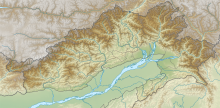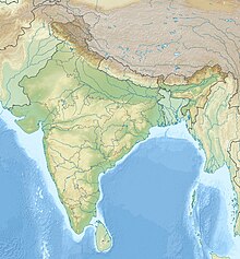
Upper Subansiri (Pron:/su:bənˈsɪɹi/) is an administrative district in the state of Arunachal Pradesh in India.

Pasighat is the headquarters of East Siang district in the Indian state of Arunachal Pradesh. Situated at the eastern foothills of the Himalayas at 155 meters (509 ft) above mean sea level, Pasighat is Arunachal's oldest town. The Government of India included Pasighat in the Smart Cities Mission development scheme in June 2017.

Aalo, formerly Along, is a census town and headquarter of the West Siang district district of the Indian state of Arunachal Pradesh. It is located 220 kilometres (140 mi) from Likabali, which is at the border of Assam and Arunachal Pradesh.
Diphu Pass is a mountain pass around the area of the disputed tri-point borders of India, China, and Myanmar. Diphu Pass is also a strategic approach to eastern Arunachal Pradesh in India. It lies on the McMahon Line. It is located in Anjaw district of Arunachal Pradesh, 120 km northeast of district headquarter at Hawai via Hawai-Walong-Dong-Kibithu-Kaho-Dhipu Pass route. Kaho on LAC is 40 km west of Dhipu Pass. Walong airstrip, 60 km away, has the nearest air connectivity.
Kadapa Airport is a regional airport serving Kadapa in Andhra Pradesh, India. It is located 12 km (7.5 mi) from the city, and is spread over 669.5 acres (270.9 ha) of land and has been upgraded at a cost of Rs. 42 crore. The upgraded airport was inaugurated on 7 June 2015 by the then Minister of Civil Aviation, Ashok Gajapathi Raju. The terminal building has a capacity to handle 100 peak hour passengers at a time and the apron can accommodate two ATR-72 aircraft.

Pasighat Airport is a regional airport serving Pasighat, Arunachal Pradesh, India.
Tezu Airport is a regional airport serving Tezu, Arunachal Pradesh, India. It is operated by the Airports Authority of India (AAI), which upgraded it to handle ATR-72 aircraft with night-landing facility. Prime Minister Narendra Modi inaugurated the upgraded airport on 9 February 2019. Scheduled commercial flights commenced from 19 August 2021.

The Sino-Indian border dispute is an ongoing territorial dispute over the sovereignty of two relatively large, and several smaller, separated pieces of territory between China and India. The first of the territories, Aksai Chin, is administered by China as part of the Xinjiang Uygur Autonomous Region and Tibet Autonomous Region and claimed by India as part of the union territory of Ladakh; it is the most uninhabited high-altitude wasteland in the larger regions of Kashmir and Tibet and is crossed by the Xinjiang-Tibet Highway, but with some significant pasture lands at the margins. The other disputed territory is south of the McMahon Line, formerly known as the North-East Frontier Agency and now called Arunachal Pradesh. The McMahon Line was part of the 1914 Simla Convention signed between British India and Tibet, without China's agreement. China disowns the agreement, stating that Tibet was never independent when it signed the Simla Convention.

Thoise or Thoise Airbase is a military airfield and small village in Nubra region of Ladakh, India, occupying the only large piece of flat land in the area. The airstrip is a critical facility enabling a quick inflow of men and material from the Indian interior to Siachen, a glacier, helipad and battleground near the Actual Ground Position Line between India and Pakistan.

Mechukha or Menchukha is a town, assembly constituency and subdivision, situated 6,000 feet (1,829 m) above sea level in the Mechukha Valley of Yargep Chu/ Siyom River in Shi Yomi district of Arunachal Pradesh state of India. Before the 1950s, Mechuka valley was known as Pachakshiri.

Pakyong Airport is a domestic airport serving Pakyong, Gangtok, the capital of Sikkim, India.

Itanagar Airport, also known as Hollongi Airport and Donyi Polo Airport (officially), is an under-construction greenfield airport, which will serve Itanagar, the capital city of Arunachal Pradesh, India. It is being constructed at Hollongi, situated 14 kilometres south from the city centre, in the Papum Pare district. It is being built by the Airports Authority of India, over an area of 320 hectares. The project entails construction of a 2,300 metre runway, a terminal building measuring 5,100 square metres to handle 200 passengers during peak hours, an Air Traffic Control (ATC) tower, a technical block and a fire station, with provisions for commercial activities such as a hotel and a convention centre. The apron will measure 115 metres by 106 metres, suitable for parking two Airbus A321 aircraft. Prime Minister Narendra Modi laid the foundation stone for the airport on 9 February 2019. Construction was started on 15 December 2020, and the initial completion date was scheduled to November 2022, but it has been brought forward to 15 August 2022 to mark 75 years of India's Independence.

Tuting is a town and headquarters of an eponymous circle in the Upper Siang district in Arunachal Pradesh, India. It is situated on the bank of Siang river (Brahmaputra) at a distance of 34 km south of Line of Actual Control and 170 kilometres north of Yingkiong. Tuting is the center of an assembly constituency, and also home to an Indian Military headquarters. The border area reports frequent incursion attempts by the Chinese People's Liberation Army, including an attempt to construct a road in Indian territory.

The Bhupen Hazarika Setu, commonly known as the Dhola Sadiya Bridge, is a beam bridge in India, connecting the northeast states of Assam and Arunachal Pradesh. The bridge spans the Lohit River, a major tributary of the Brahmaputra, connecting the village of Dhola in the south to the village of Sadiya to the north, both in Tinsukia district of Assam, and providing convenient access to Arunachal Pradesh, whose border lies a short distance from Sadiya. The bridge is the first permanent road connection between the northern Assam and eastern Arunachal Pradesh.
Tawang Air Force station in Arunachal Pradesh in India has a functional heliport and fixed-wing "Advanced Landing Ground" (AGL) capable of handling Lockheed Martin C-130J Super Hercules transport aircraft. The Indian Air Force (IAF) has since 2016 upgraded 8 ALG in Arunachal Pradesh and made those operation by 2018, all of which has been offered for the operation of civil helicopter and flights for tourism and the UDAN scheme.

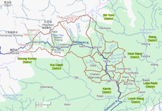
Shi Yomi district is one of the 23 districts of Arunachal Pradesh state in northeastern India. Shi-Yomi district was created on 9 December 2018 by dividing the West Siang district when northern areas along the China border were made into a newly created Shi-Yomi district and the remaining southern areas remains the part truncated West Siang district. It has its headquarters at Tato.
Mechuka Advanced Landing Ground is an Indian Air Force airstrip located at Mechuka in Shi Yomi district of Arunachal Pradesh, India. It is an Advance Landing Ground (ALG) of Indian Air Force.
Walong Advanced Landing Ground is an Indian Air Force airstrip located at Walong on the banks of Lohit River in Anjaw District of Arunachal Pradesh, India. It is nearly 50 km north of district headquarter at Hawai, nearly 30 km south of India-China LAC, and 70 km southwest of Diphu Pass near India-China-Myanmar tri-junction.
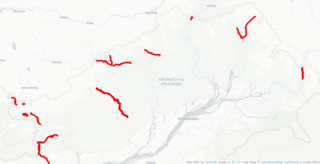
India-China Border Roads is a Government of India project for developing infrastructure along the Sino-Indian border by constructing strategic roads, including bridges and tunnels. The ICBR project is largely in response to Chinese infrastructure development along the borderlands with India.