
Pasighat is the headquarters of East Siang district in the Indian state of Arunachal Pradesh. Situated at the eastern foothills of the Himalayas at 155 meters (509 ft) above mean sea level, Pasighat is Arunachal's oldest town. The Government of India included Pasighat in the Smart Cities Mission development scheme in June 2017.

Aalo, formerly Along, is a census town and headquarter of the West Siang district district of the Indian state of Arunachal Pradesh. It is located 137 kilometres (85 mi) from Likabali, which is at the border of Assam and Arunachal Pradesh.
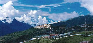
Tawang is a town and administrative headquarter of Tawang district in the Indian state of Arunachal Pradesh. The town was once the capital of the Tawang Tract, which is now divided into the Tawang district and the West Kameng district. Tawang continues as the headquarters of the former. Tawang is the number one tourist destination of Arunachal Pradesh.
Daporijo Airport is located at Daporijo in the state of Arunachal Pradesh, India. Daporijo used to have scheduled services in the 1980s and early 1990s from Vayudoot. The airport had flights to Guwahati and Dibrugarh on Dornier 228 aircraft. Currently, there is no scheduled commercial air service to the airport, although the airport is used by the Indian Army. The Airports Authority of India (AAI) plans to develop the airport for operation of ATR-42/ATR-72 type of aircraft.
Pasighat Airport is a domestic airport serving Pasighat, Arunachal Pradesh, India.
Tezu Airport is a domestic airport serving the city of Tezu and adjoining Lohit district of Arunachal Pradesh, India. It is operated by the Airports Authority of India (AAI), which upgraded it to handle ATR-72 aircraft with night-landing facility. Prime Minister Narendra Modi inaugurated the upgraded airport on 9 February 2019. Scheduled commercial flights commenced from 19 August 2021.

Thoise or Thoise Airbase is a military airfield and small village in Nubra region of Ladakh, India, occupying the only large piece of flat land in the area. The airstrip is a critical facility enabling a quick inflow of men and material from the Indian interior to Siachen, a glacier, helipad and battleground near the Actual Ground Position Line between India and Pakistan.
The Trans-Arunachal Highway (TAH), which includes an existing 1,811 km (1,125 mi) route comprising NH-13 and parts of NH-15, NH-215 and SH-25, is an under-construction 2-lane more than 2,407 km (1,496 mi) long highway passing through 16 districts in Arunachal Pradesh state in India. It runs from LAC in Tawang in northwest to Kanubari in southeast at tri-junction of Assam-Nagaland-Arunachal Pradesh. It connects at least 16 districts of Arunachal Pradesh.

Mechukha or Menchukha is a town, assembly constituency and subdivision, situated 6,000 feet (1,829 m) above sea level in the Mechukha Valley of Yargep Chu/ Siyom River in Shi Yomi district of Arunachal Pradesh state of India. Before the 1950s, Mechuka valley was known as Pachakshiri.

Air Force Station Hindon is an Indian Air Force base under the Western Air Command (WAC). It is the biggest and largest air base in Asia. Its area measured 14 km rounded and 55 square kilometres (21 sq mi). This base celebrates Air Force Day on 8 October. It is located near Loni Ghaziabad in the state of Uttar Pradesh in the National Capital Region on the outskirts of Delhi, close to the Hindon River. Starting 2006, the annual Air Force Day Parade venue was shifted from Palam Airport to Hindon. There is one runway, aligned east–west (09-27), of 9,000 feet (2,700 m) length x 150 feet (46 m) width. The military airbase serves as the home of the IAF C-17 Globemaster and the IAF C-130J Super Hercules, the backbone of Strategic Heavy Air Lift division of the Indian Air Force. The Airports Authority of India (AAI) operates a civil enclave at Hindon as part of the government's Regional Connectivity Scheme (RCS).
Arunachal Frontier Highway (AFH), officially notified as the National Highway NH-913 and also called Bomdila-Vijaynagar Highway (BVH), connecting Bomdila Airstrip ALG & HQ in northwest to Vijaynagar Airstrip ALG & HQ in southeast via Nafra HQ-Sarli HQ-Huri Helipad ALG & HQ-Nacho HQ-Mechuka Airstrip ALG & HQ-Monigong HQ-Jido -Hunli HQ-Hayuliang Airstrip ALG HQ-Chenquenty-Hawai HQ-Miao HQ including 800 km greenfield section and network of new tunnels & bridges, is a 2-lane paved-shoulder under-construction national highway along the India-China LAC-McMahon Line border in the Indian state of Arunachal Pradesh. The 1,748 km-long (1,086 mi) highway itself will cost ₹27,000 crore (US$3.4 billion) and total cost including 6 additional inter-corridors is ₹40,000 crore (US$5.0 billion). In some places, this highway will run as close as 20 km from the LAC. To be constructed by MoRTH in 9 packages, all packages will be approved by the end of fy 2024-25 and construction will be completed in 2 years by 31 March 2027. This highway in the north & east Arunachal along the China border, would complement the Trans-Arunachal Highway and the Arunachal East-West Corridor as major highways spanning the whole state, pursuing the Look East connectivity policy.

Tuting is a town and headquarters of an eponymous circle in the Upper Siang district in Arunachal Pradesh, India. It is situated on the bank of Siang river (Brahmaputra) at a distance of 34 km (21 mi) south of Line of Actual Control and 170 km (110 mi) north of Yingkiong. Tuting is the center of an assembly constituency, and also home to an Indian Military headquarters. The border area reports frequent incursion attempts by the Chinese People's Liberation Army, including an attempt to construct a road in Indian territory.
Vijaynagar is the most remote town and circle headquarters in the Changlang district, Arunachal Pradesh, India.
Lumla is a town and the headquarters of an eponymous circle in the Tawang district in Arunachal Pradesh, India. Lumla is at the southwestern corner of the Tawang district close to its border with Bhutan. Lumla is also the headquarters of a subdivision of the Tawang district and the centre of a Legislative Assembly constituency. The current member of the legislative assembly (MLA) from Lumla is Jambey Tashi.

Shi Yomi district is one of the 23 districts of Arunachal Pradesh state in northeastern India. Shi-Yomi district was created on 9 December 2018 by dividing the West Siang district when northern areas along the China border were made into a newly created Shi-Yomi district and the remaining southern areas remain the part truncated West Siang district. It has its headquarters at Tato.
Mechuka Advanced Landing Ground is an Indian Air Force airstrip located at Mechuka in Shi Yomi district of Arunachal Pradesh, India. It is an Advance Landing Ground (ALG) of Indian Air Force.
Walong Advanced Landing Ground is an Indian Air Force airstrip located at Walong on the banks of Lohit River in Anjaw District of Arunachal Pradesh, India. It is nearly 50 km north of district headquarter at Hawai, nearly 30 km south of India-China LAC, and 70 km southwest of Diphu Pass near India-China-Myanmar tri-junction.
India–China Border Roads is a Government of India project for developing infrastructure along the Sino-Indian border by constructing strategic roads, including bridges and tunnels. The ICBR project is largely in response to Chinese infrastructure development along the borderlands with India.

