
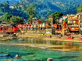
Champawat is a town and a Nagar Palika Parishad in Champawat district in the state of Uttarakhand, India. It is the administrative headquarters of Champawat district. The town was the former capital of the Kumaon Kingdom.

Uttarakhand, also known as Uttaranchal, is a state in the northern India. It is often referred to as the "Devbhumi" due to its religious significance and numerous Hindu temples and pilgrimage centres found throughout the state. Uttarakhand is known for the natural environment of the Himalayas, the Bhabar and the Terai regions. It borders the Tibet Autonomous Region of China to the north; the Sudurpashchim Province of Nepal to the east; the Indian states of Uttar Pradesh to the south and Himachal Pradesh to the west and north-west. The state is divided into two divisions, Garhwal and Kumaon, with a total of 13 districts. The winter capital of Uttarakhand is Dehradun, the largest city of the state, which is a rail head. Bhararisain, a town in Chamoli district, is the summer capital of Uttarakhand. The High Court of the state is located in Nainital, but is to be moved to Haldwani in future.

Almora is a district in the Kumaon Division of Uttarakhand state, India. The headquarters is at Almora. It is 1,638 meters above sea level. The neighbouring regions are Pithoragarh district to the east, Chamoli district to the west, Bageshwar district to the north and Nainital district to the south.

Haldwani is the largest city of Kumaon. It is also the third most populous city and largest commercial market in the Indian state of Uttarakhand. Haldwani is said to be the financial capital of Uttarakhand, having the most commercial, economic and industrial activities of the state. Haldwani is located in the Nainital District, and is one of its eight Subdivisions. The Haldwani Urban agglomeration has 232,060 people as of 2011, and is the third most populous UA in Uttarakhand, after Dehradun and Haridwar. Being situated in the immediate foothills of Kumaon Himalayas, the Kathgodam neighbourhood of Haldwani is known as the "Gateway to Kumaon".
Gairsain is a town in Chamoli district of the Indian state of Uttarakhand near state's summer capital Bhararisain. A town and Nagar Panchayat, Gairsain is situated at the eastern edge of the vast Dudhatoli mountain range, and is located in Chamoli district almost at the centre of the state, at a distance of approximately 250 kilometres from Dehradun. It is easily accessible from both the Garhwal and the Kumaon divisions, and in a way, acts as the bridge between the two regions. It is being considered as the future Permanent capital of Uttarakhand.

Didihat is a town and a Nagar Palika in Pithoragarh District in the state of Uttarakhand, India. It is one of the eleven administrative subdivisions of Pithoragarh district and also serves as its administrative headquarter. With a population of 6522, Didihat is located at a distance of 415 km (258 mi) from the state capital Dehradun.

Pithoragarh is a Himalayan town with a Municipal Board in Pithoragarh district in the Indian state of Uttarakhand. It is the fourth largest town of Kumaon and the largest in Kumaon hills. It is an education hub of the hilly region as the town has Laxman Singh Mahar Govt.P.G.College, Seemant Institute of Technology, now known as Nanhi Pari Seemant Engineering Institute and a nursing college.
Bageshwar is a town and a municipal board in Bageshwar district in the state of Uttarakhand, India. It is located at a distance of 470 km from the National Capital New Delhi and 332 km from the State Capital Dehradun. Bageshwar is known for its scenic environment, glaciers, rivers and temples. It is also the administrative headquarters of Bageshwar district.
Kashipur is a city of Udham Singh Nagar district in the Indian state of Uttarakhand, and one of its seven subdivisions. Located in the western part of Udham Singh Nagar district, it is Kumaun's third most populous city and the sixth most populous in Uttarakhand. According to the 2011 Census of India, the population is 121,623 for the city of Kashipur and 283,136 for Kashipur Tehsil. Kashipur also has IIM Kashipur, one of the thirteen Indian Institutes of Managements the government has set up during the Eleventh Five-year Plan.
Rudrapur is a city that serves as the headquarters of the Udham Singh Nagar district in the Indian state of Uttarakhand. Located at a distance of about 250 km (160 mi) northeast of New Delhi and 250 km (160 mi) south of Dehradun, Rudrapur is located in the fertile Terai plains in the southern part of Kumaon division over an area of 27.65 km2. With a population of 140,857 according to the 2011 census of India, it is the 5th most populous city of Uttarakhand.

Tanakpur is a city and a municipal board in Champawat district of Uttarakhand state of India. Located in the plains area in the northern part of India. The town is the gateway for Purnagiri Temple as well as the 'Gateway to the Kumaon Himalayas'.
Dehradun Airport, also known as Jolly Grant Airport, is a domestic airport serving Dehradun, the capital of Uttarakhand, India, located 25 km south of the city. Commercial operations began on 30 March 2008, after a runway extension to accommodate larger aircraft. A new terminal building was inaugurated in February 2009. The current passenger terminal was inaugurated in October 2021. Located 20 km (12 mi) from Rishikesh, and 35 km (22 mi) from Haridwar, the airport Dehradun Airport is the 30th busiest airport in India, with over 1 million annual passengers.

Berinag is a hill station, located 124 km from Pithoragarh city in the Pithoragarh district, which is the easternmost Himalayan district in the state of Uttarakhand, India. It is one of the six Administrative Subdivisions (tehsil) of Pithoragarh district. National Highway 309A passes through Berinag. Closest prominent villages include Garawon, Dhanoli, Bana, Bhattigaon, Banoli, Quarali, Tripuradevi and Sangarh.

Ramnagar is a town and municipal board in the Nainital district of Kumaon, India. It is located approximately 65 kilometres (40 mi) from Nainital, the headquarters of the district.
Pantnagar Airport is a domestic airport serving Pantnagar, located in Udham Singh Nagar district in of Uttarakhand, India. It is operated by the Airports Authority of India. It is the nearest airport to the Kumaon division and is located in the middle of Haldwani and Rudrapur, the two largest cities of Kumaon. It is only (26 km) from Haldwani City. Kumaon hill stations of Nainital (65 km), Bhimtal (50 km), Ranikhet (110 km) and Almora (120 km), Bareilly (65 km) and the Jim Corbett National Park (120 km) are also nearby.

Chaudhary Charan Singh International Airport is an international airport serving Lucknow, the capital of the Indian state of Uttar Pradesh. It is located in Amausi, 14 km (8.7 mi) from the city centre, and was earlier known as ''Amausi Airport''. It was later renamed in 2008 after Chaudhary Charan Singh, the fifth Prime Minister of India. It is owned and operated by the Lucknow International Airport Limited (LIAL), a public–private consortium led by Adani Group.

Pithoragarh Airport, also known as Naini Saini Airport, is in Pithoragarh, Kumaon, Uttarakhand, India. The airport was constructed in 1991 for administrative use and planned for the operations of Dornier 228 type aircraft. The State Government plans to upgrade it to Category 2C airport under Visual flight rules (VFR) conditions to facilitate operations of ATR-42 type of aircraft. Recently the Helicopter commercial services to Dehradun and Pantnagar have been started. It is 4.5 kilometers from Pithoragarh city centre. But it's not operational at present.
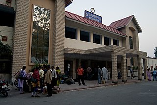
Kathgodam railway station is railway station located in Kathgodam town near Haldwani, just 35 km from Nainital Town in Nainital district of Uttarakhand State of India.

Air Heritage is an air charter company in India owned by Heritage Aviation.
