Arunachal Pradesh is a state in Northeastern India. It was formed from the erstwhile North-East Frontier Agency (NEFA) region, and became a state on 20 February 1987. It borders the states of Assam and Nagaland to the south. It shares international borders with Bhutan in the west, Myanmar in the east, and a disputed border with China in the north at the McMahon Line. Itanagar is the state capital of Arunachal Pradesh. Arunachal Pradesh is the largest of the Seven Sister States of Northeast India by area. Arunachal Pradesh shares a 1,129 km border with China's Tibet Autonomous Region.

East Siang is an administrative district in the state of Arunachal Pradesh in India.

Pasighat is the headquarters of East Siang district in the Indian state of Arunachal Pradesh. Situated at the eastern foothills of the Himalayas at 155 meters (509 ft) above mean sea level, Pasighat is Arunachal's oldest town. The Government of India included Pasighat in the Smart Cities Mission development scheme in June 2017.
Tezu is a census town and the headquarters of Lohit district in the Indian state of Arunachal Pradesh. It is the fifth largest town in Arunachal Pradesh and one of its most developed.

Yingkiong is a town in and the administrative headquarters of Upper Siang district in the Northeast Indian state of Arunachal Pradesh. It is located 250 kilometres (160 mi) north of Itanagar, the capital of the state, and 1 kilometre (0.62 mi) east of the River Siang. According to the 2011 Census, the town has a total population of 8,573.
Dhemaji is a City in Assam and it is the headquarters of Dhemaji district, Assam, India.
Deomali is a census town in Tirap district in the state of Arunachal Pradesh, India. The small sub-divisional town has scenic beauty and is surrounded by hills, tea gardens, forests and rivers.
Daporijo Airport is located at Daporijo in the state of Arunachal Pradesh, India. Daporijo used to have scheduled services in the 1980s and early 1990s from Vayudoot. The airport had flights to Guwahati and Dibrugarh on Dornier 228 aircraft. Currently, there is no scheduled commercial air service to the airport, although the airport is used by the Indian Army. The Airports Authority of India (AAI) plans to develop the airport for operation of ATR-42/ATR-72 type of aircraft.

Pasighat Airport is a regional airport serving Pasighat, Arunachal Pradesh, India.
Arunachal Pradesh is gradually improving with several plans and projects being initiated by both state and central government. Furthermore, there are local NGOs in the state who have undertaken several projects to bring about awareness among the people about the importance of literacy on in far-flung areas. The average literacy rate in Arunachal Pradesh is 82.93% as of the latest report for December 2020. This article provides an outline of the Arunachal Pradesh Education system.
The Trans-Arunachal Highway (TAH), which includes an existing 1,811 km (1,125 mi) route comprising NH-13 and parts of NH-15, NH-215 and SH-25, is an under-construction 2-lane more than 2,407 km (1,496 mi) long highway passing through 16 districts in Arunachal Pradesh state in India. It runs from LAC in Tawang in northwest to Kanubari in southeast at tri-junction of Assam-Nagaland-Arunachal Pradesh. It connects at least 16 districts of Arunachal Pradesh.
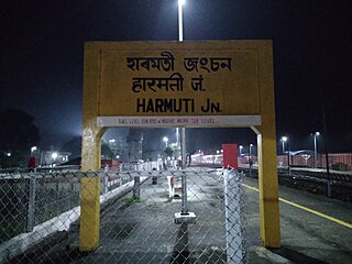
The Rangiya-Murkongselek section is a 450 km (280 mi) long railway line connecting Rangiya in Kamrup district with Murkongselek in Dhemaji district in the Indian state of Assam. The entire section is under the jurisdiction of Northeast Frontier Railway.

Itanagar Airport, also known as Hollongi Airport and Donyi Polo Airport (officially), is an under-construction greenfield airport, which will serve Itanagar, the capital city of Arunachal Pradesh, India. It is being constructed at Hollongi, situated 14 kilometres south from the city centre, in the Papum Pare district. It is being built by the Airports Authority of India, over an area of 320 hectares. The project entails construction of a 2,300 metre runway, a terminal building measuring 5,100 square metres to handle 200 passengers during peak hours, an Air Traffic Control (ATC) tower, a technical block and a fire station, with provisions for commercial activities such as a hotel and a convention centre. The apron will measure 115 metres by 106 metres, suitable for parking two Airbus A321 aircraft. Prime Minister Narendra Modi laid the foundation stone for the airport on 9 February 2019. Construction was started on 15 December 2020, and the initial completion date was scheduled to November 2022, but it has been brought forward to 15 August 2022 to mark 75 years of India's Independence.
Daying Ering (1929–1970) was an Indian politician from Arunachal Pradesh. He was the chairman of the Ering Commission which heavily influenced the country's panchayati raj system.
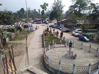
Ruksin is a Sub-Division and Major City located in the East Siang district, Arunachal Pradesh.

Tuting is a town and headquarters of an eponymous circle in the Upper Siang district in Arunachal Pradesh, India. It is situated on the bank of Siang river (Brahmaputra) at a distance of 34 km (21 mi) south of Line of Actual Control and 170 km (110 mi) north of Yingkiong. Tuting is the center of an assembly constituency, and also home to an Indian Military headquarters. The border area reports frequent incursion attempts by the Chinese People's Liberation Army, including an attempt to construct a road in Indian territory.
East-West Industrial Corridor Highway of Arunachal Pradesh, a 2-lane and 966.78 km long including existing 274.20 km Pasighat-Manmao route, is a proposed highway across lower foothills of Arunachal Pradesh state in India from Bhairabkunda in Assam at tri-junction of Bhutan-Assam-Arunachal Pradesh in west to Kanubari tri-junction of Nagaland-Assam-Arunachal Pradesh in east.

National Highway 13, part of the larger Trans-Arunachal Highway network, is a 1,559 km long two-lane national highway across Arunachal Pradesh in India running from Tawang in northwest to Wakro in southeast. Entire route became operational in 2018 when 6.2 km long Dibang River Bridge was completed across Dibang River. Sela Tunnel, a shorter alternative route with target completion by Jan/Feb 2022, will provide all-weather connectivity. Before the renumbering of highways, it was known as NH 229 and NH52. This strategically important highway enhances Indian military's capabilities in combating the threat of China's Western Theater Command opposite India's eastern sector of Line of Actual Control.
Tawang Air Force station in Arunachal Pradesh in India has a functional heliport and fixed-wing "Advanced Landing Ground" (AGL) capable of handling Lockheed Martin C-130J Super Hercules transport aircraft. The Indian Air Force (IAF) has since 2016 upgraded 8 ALG in Arunachal Pradesh and made those operation by 2018, all of which has been offered for the operation of civil helicopter and flights for tourism and the UDAN scheme.
Lekang is a village and Tehsil in the Namsai district of Arunachal Pradesh state, India. According to the 2011 Census of India, it has 1,536 residents across 369 households. 828 are male and 708 are female.