Dickinson, Franklin County, New York

Last updated

Dickinson, New York
USA New York location map.svg
Red pog.svg
Dickinson
Location within the state of New York
Coordinates: 44°43′54″N74°32′5″W / 44.73167°N 74.53472°W / 44.73167; -74.53472
Country United States
State New York
County Franklin
Named for Philemon Dickinson
Government
  Type Town Council
   Town Supervisor Sherry Smith (R)
   Town Council
Members' List
Area
[1]
  Total44.31 sq mi (114.77 km2)
  Land44.22 sq mi (114.54 km2)
  Water0.09 sq mi (0.23 km2)
Elevation
Ranges between 700−1,300 ft. ft (283 m)
Population
 (2010)
  Total823
  Estimate 
(2016) [2]
799
  Density18.07/sq mi (6.98/km2)
Time zone UTC-5 (Eastern (EST))
  Summer (DST) UTC-4 (EDT)
FIPS code 36-20610
GNIS feature ID0978904

Dickinson is a town in Franklin County, New York, United States. The population was 823 at the 2010 census. [3] The town was named after Philemon Dickinson, a brigadier general of the New Jersey militia during the American Revolutionary War.

Contents

Dickinson is on the western border of Franklin County, southwest of Malone and east of Potsdam.

History

The name originally proposed for the area was "Annastown", after the daughter of a local landowner; but another influential landowner, Jonathan Dayton, prevailed in naming the town after his friend and fellow member of congress Philemon Dickinson.

The town of Dickinson was formed from the town of Malone in 1809. In 1812, part of Dickinson was used to form the town of Bangor. The creation of the towns of Moira in 1828 and Waverly in 1880 cost Dickinson more territory.

In 1843, conversions to the Mormon religion and migration westward took place in the town, due to relatives of a Mormon apostle living there.

Geography

According to the United States Census Bureau, the town has a total area of 44.3 square miles (114.8 km2), of which 44.2 square miles (114.5 km2) is land and 0.1 square miles (0.2 km2), or 0.20%, is water. [3]

The western town line is the border of St. Lawrence County. The town is located along the northern edge of the Adirondacks.

New York State Route 11B is an east-west highway.

Demographics

Historical population
CensusPop.Note
1820 495
1830 446−9.9%
1840 1,005125.3%
1850 1,11911.3%
1860 1,91771.3%
1870 1,9903.8%
1880 2,32917.0%
1890 1,664−28.6%
1900 1,6911.6%
1910 1,609−4.8%
1920 1,312−18.5%
1930 1,061−19.1%
1940 934−12.0%
1950 834−10.7%
1960 8572.8%
1970 832−2.9%
1980 786−5.5%
1990 751−4.5%
2000 739−1.6%
2010 82311.4%
2016 (est.)799 [2] −2.9%
U.S. Decennial Census [4]

As of the census [5] of 2000, there were 739 people, 293 households, and 217 families residing in the town. The population density was 16.7 people per square mile (6.4/km2). There were 424 housing units at an average density of 9.6 per square mile (3.7/km2). The racial makeup of the town was 97.56% White, 0.41% African American, 1.22% Native American, 0.14% Asian, and 0.68% from two or more races. Hispanic or Latino of any race were 0.41% of the population.

There were 293 households, out of which 29.7% had children under the age of 18 living with them, 57.7% were married couples living together, 8.9% had a female householder with no husband present, and 25.9% were non-families. 20.1% of all households were made up of individuals, and 8.2% had someone living alone who was 65 years of age or older. The average household size was 2.52 and the average family size was 2.88.

In the town, the population was spread out, with 24.6% under the age of 18, 6.5% from 18 to 24, 27.3% from 25 to 44, 26.4% from 45 to 64, and 15.2% who were 65 years of age or older. The median age was 39 years. For every 100 females, there were 107.0 males. For every 100 females age 18 and over, there were 101.8 males.

The median income for a household in the town was $31,711, and the median income for a family was $34,875. Males had a median income of $27,083 versus $22,039 for females. The per capita income for the town was $15,701. About 11.2% of families and 16.5% of the population were below the poverty line, including 30.1% of those under age 18 and 15.4% of those age 65 or over.

Communities and locations in Dickinson

Notable person

Related Research Articles

<span class="mw-page-title-main">Chenango, New York</span> Town in New York, United States

Chenango is a town in Broome County, New York, United States. The population was 10,983 at the 2020 census.

<span class="mw-page-title-main">Fenton, New York</span> Town in New York, United States

Fenton is a town in Broome County, New York, United States. The population was 6,441 at the 2020 census. The town was named after Reuben Fenton, a governor of New York.

<span class="mw-page-title-main">Black Brook, New York</span> Town in New York, United States

Black Brook is a town in Clinton County, New York, United States. The population was 1,497 at the 2010 census. It is named after a stream that flows through the town.

<span class="mw-page-title-main">Clinton, Clinton County, New York</span> Town in New York, United States

Clinton is a town in Clinton County, New York, United States. The population was 737 at the 2010 census. The town is located in the northwestern corner of the county and is northwest of Plattsburgh.

<span class="mw-page-title-main">Saranac, New York</span> Town in New York, United States

Saranac is a town in Clinton County, New York, United States. The town is on the western border of the county, west of Plattsburgh, and is within the Adirondack Park. The population was 4,007 at the 2010 census. The town is named for the Saranac River that flows through the town.

Bangor is a town in Franklin County, New York, United States. The population was 2,231 at the 2020 census. The town is named after Bangor in Wales.

<span class="mw-page-title-main">Franklin, Franklin County, New York</span> Town in New York, United States

Franklin is a town located in Franklin County, New York, United States. As of the 2010 census, the town had a population of 1,140.

<span class="mw-page-title-main">Moira, New York</span> Town in New York, United States

Moira is a town in Franklin County, New York, United States. The population was 2,934 at the 2010 census. Moira is located on the western border of Franklin County and is west of Malone. The town was named for the Earl of Moira. The correct pronunciation of Moira is moʊ-aɪ-rʌ.

<span class="mw-page-title-main">Waverly, Franklin County, New York</span> Town in New York, United States

Waverly is a town in Franklin County, New York, United States. The population was 1,022 at the 2010 census. The town is on the western border of the county, southwest of Malone.

<span class="mw-page-title-main">Kirkland, New York</span> Town in Oneida County, New York, United States

Kirkland is a town in Oneida County, New York, United States. The population was 10,075 at the 2020 census. The town is named after Samuel Kirkland, a missionary among the Oneidas.

<span class="mw-page-title-main">Clifton, New York</span> Town in New York, United States

Clifton is a town in St. Lawrence County, New York, United States. The population was 675 at the 2020 census. The town takes its name from a mining company.

<span class="mw-page-title-main">De Kalb, New York</span> Town in New York, United States

DeKalb is a town in St. Lawrence County, New York, United States. The population was 2,434 at the 2010 census. The town is named after American general Baron de Kalb, a German officer serving under George Washington.

<span class="mw-page-title-main">Fowler, New York</span> Town in New York, United States

Fowler is a town in St. Lawrence County, New York, United States. The population was 2,202 at the 2010 census.

<span class="mw-page-title-main">Hopkinton, New York</span> Town in New York, United States

Hopkinton is a town in St. Lawrence County, New York, United States. The population was 1,105 at the 2020 census and has a Population density of 5.9 square miles. The town is named for Roswell Hopkins, a pioneer settler and a government official.

Lawrence is a town in St. Lawrence County, New York, United States. The population was 1,715 at the 2020 census. The town is named after William Lawrence, an early land owner.

<span class="mw-page-title-main">Macomb, New York</span> Town in New York, United States

Macomb is a town in St. Lawrence County, New York, United States. The population was 906 at the 2010 census. The town is named after Alexander Macomb, who once owned much of northern New York as Macomb's Purchase.

<span class="mw-page-title-main">Rossie, New York</span> Town in New York, United States

Rossie is a town in St. Lawrence County, New York, United States. The population was 877 at the 2010 census. The town is named after the sister of an early land owner.

<span class="mw-page-title-main">Stockholm, New York</span> Town in New York, United States

Stockholm is a town in St. Lawrence County, New York, United States. The population was 3,665 at the 2010 census. The name was assigned by surveyors from Stockholm in Sweden.

Burke is a town in Franklin County, New York, United States. The population was 1,465 at the 2010 census. The town is in the northeastern part of the county, northeast of Malone, the county seat.

<span class="mw-page-title-main">Hermon, New York</span> Town in New York, United States

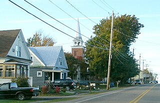
Hermon is a town in St. Lawrence County, New York, United States. The population was 1,108 at the 2010 census. Hermon is named after Mount Hermon in Israel, which is the name corresponding to Mount Jabal al-Sheikh in Syria. The town contains a hamlet also called Hermon, and is in the south-central part of the county, southwest of Canton.

References

  1. "2016 U.S. Gazetteer Files". United States Census Bureau. Retrieved July 5, 2017.
  2. 1 2 "Population and Housing Unit Estimates" . Retrieved June 9, 2017.
  3. 1 2 "Geographic Identifiers: 2010 Census Summary File 1 (G001), Dickinson town, Franklin County, New York". American FactFinder. U.S. Census Bureau. Archived from the original on February 13, 2020. Retrieved June 13, 2016.
  4. "Census of Population and Housing". Census.gov. Retrieved June 4, 2015.
  5. "U.S. Census website". United States Census Bureau . Retrieved January 31, 2008.
  6. "National Register Information System". National Register of Historic Places . National Park Service. March 13, 2009.

44°44′54″N74°33′53″W / 44.74833°N 74.56472°W / 44.74833; -74.56472