Waverly is a town in Franklin County, New York, United States. The population was 1,022 at the 2010 census. The town is on the western border of the county, southwest of Malone.
Depauville is a hamlet and census-designated place (CDP) in the southern region of the town of Clayton, within Jefferson County, New York, United States. The population was at 577 at the 2010 census.

Brasher is a town in St. Lawrence County, New York, United States. The population was 2,512 at the 2010 census. The town is named after Philip Brasher, an original landowner.

Hopkinton is a town in St. Lawrence County, New York, United States. The population was 1,020 at the 2020 census and has a Population density of 5.8 square miles. The town is named for Roswell Hopkins, a pioneer settler.

Great Falls is a census-designated place (CDP) in Fairfax County, Virginia, United States. The population as of the 2010 census was 15,427, an increase of 80.5% from the 2000 census.

Mallory is a census-designated place (CDP) in Logan County, West Virginia, United States. The population was 1,654 at the 2010 census. The CDP contains the unincorporated communities, from west to east, of Huff Junction, Mallory, Davin, Mineral City, Claypool, Combs Addition, and Gillman Bottom.
Littleton is a census-designated place (CDP) and the main village in the town of Littleton in Grafton County, New Hampshire, United States. The population of the CDP was 4,467 at the 2020 census, out of 6,005 in the entire town.
Exeter is a census-designated place (CDP) and the main village in the town of Exeter, Rockingham County, New Hampshire, United States. The population of the CDP was 10,109 at the 2020 census, out of 16,049 in the entire town.

Paul Smiths is a hamlet and census-designated place (CDP) in the Town of Brighton in Franklin County, New York, United States. It is located on Lower Saint Regis Lake in the Adirondacks, 12 miles (19 km) northwest of Saranac Lake, located at 44°26' North 74°15' West. The population of the CDP was 671 at the 2010 census.

New Tripoli is an unincorporated community and census-designated place (CDP) in Lynn Township in Lehigh County, Pennsylvania. As of the 2010 census, the population was 898. New Tripoli is part of the Lehigh Valley, which has a population of 861,899 and is the 68th most populated metropolitan area in the U.S. as of the 2020 census.
Stone Ridge is a census-designated place in Loudoun County, Virginia, United States. Residences use Aldie mailing addresses, and it is near Washington Dulles International Airport. The population as of the 2010 census was 7,214. As of the 2020 census, the population had increased to 15,039. Stone Ridge is a Van Metre Homes planned, mixed-use community.

New York State Route 458 (NY 458) is a state highway in the North Country of New York in the United States. It extends for 24.42 miles (39.30 km) from an intersection with NY 11B in the St. Lawrence County town of Hopkinton to a junction with NY 30 in the Franklin County town of Brighton. The route follows a generally northwest–southeast alignment between the two points, serving only small hamlets as it crosses an otherwise rural area of the North Country. NY 458 was assigned on July 1, 1972 to the former routing of NY 72 east of the Hopkinton hamlet of Nicholville. Prior to being signed as part of NY 72 in 1930, it was designated as part of NY 56 in the 1920s.
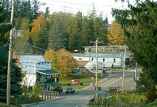
Brasher Falls is the largest hamlet and a census-designated place (CDP) in the town of Brasher in St. Lawrence County, New York, United States. As of the 2010 census, it had a population of 669.
Winthrop is a hamlet and census-designated place (CDP) in the town of Stockholm in St. Lawrence County, New York, United States. As of the 2010 census, it had a population of 510.
Fort Covington is a census-designated place (CDP) within the town of Fort Covington, Franklin County, New York, United States. It consists of the hamlet of Fort Covington, as well as a large amount of rural land surrounding the hamlet, such that the CDP occupies about one half of the area within the town limits. The population of the CDP was 1,308 at the 2010 census, out of a total town population of 1,676.
Colton is the primary hamlet and a census-designated place (CDP) in the town of Colton in St. Lawrence County, New York, United States. As of the 2010 census, it had a population of 345, out of 1,451 in the entire town of Colton.
Parishville is the primary hamlet and a census-designated place (CDP) in the town of Parishville in St. Lawrence County, New York, United States. As of the 2010 census, it had a population of 647, out of 2,153 in the entire town of Parishville.
Kysorville is a hamlet and census-designated place (CDP) in the town of West Sparta, Livingston County, New York, United States. Its population was 110 as of the 2010 census.
Shorehaven is a census-designated place (CDP) in the town of Pawling in Dutchess County, New York, United States. It was first listed as a CDP prior to the 2020 census.
Castleton Four Corners is a census-designated place (CDP) in the town of Castleton, Rutland County, Vermont, United States. It consists of the unincorporated villages of Castleton Corners and Hydeville. As of the 2020 census, the CDP had a population of 699, out of 4,458 in the entire town.


