Franklin, Franklin County, New York

Last updated

Franklin, New York
Franklin Falls New York.jpg
Franklin Falls on the Saranac River in the spring
USA New York location map.svg
Red pog.svg
Franklin
Location within the state of New York
Coordinates: 44°31′9″N74°3′38″W / 44.51917°N 74.06056°W / 44.51917; -74.06056
Country United States
State New York
County Franklin
Named for Benjamin Franklin
Government
  Type Town Council
   Town Supervisor Arthur P. Willman, Jr. (R)
   Town Council
Members' List
Area
[1]
  Total175.22 sq mi (453.82 km2)
  Land169.83 sq mi (439.85 km2)
  Water5.39 sq mi (13.97 km2)
Elevation
1,693 ft (516 m)
Population
 (2010)
  Total1,140
  Estimate 
(2016) [2]
1,136
  Density6.69/sq mi (2.58/km2)
Time zone UTC-5 (Eastern (EST))
  Summer (DST) UTC-4 (EDT)
FIPS code 36-27243
GNIS feature ID0978971
Website www.townoffranklin.com

Franklin is a town located in Franklin County, New York, United States. As of the 2010 census, the town had a population of 1,140. [3]

Contents

The town is in the southeastern part of the county, in the Adirondack Region of New York.

History

The first settlement in the town was Franklin Falls (1827). This community burned in 1852.

The town of Franklin was founded in 1836 from part of the town of Bellmont. The town was used to relocate former slaves, in part the work of Gerrit Smith, an abolitionist, and in part the result of Civil War veterans inviting freed slaves to return home with them.

The Loon Lake Mountain Fire Observation Station was listed on the National Register of Historic Places in 2008. [4]

Geography

Franklin is the third-largest town in Franklin County. According to the United States Census Bureau, the town has a total area of 175.2 square miles (453.8 km2), of which 169.8 square miles (439.8 km2) is land and 5.4 square miles (14.0 km2), or 3.08%, is water. [3] The Saranac River, a tributary of Lake Champlain, flows through the southeastern corner of the town.

Franklin is in the Adirondack Park. The eastern town line is the border of Clinton County, and the southern town boundary is the border of Essex County.

New York State Route 3 runs diagonally from southwest to northeast across Franklin. Saranac Lake is 15 miles (24 km) to the southwest, and Plattsburgh is 34 miles (55 km) to the northeast. Malone, the Franklin County seat, is 34 miles (55 km) to the northwest via County Road 26 and NY Route 30.

Demographics

Historical population
CensusPop.Note
1840 192
1850 724277.1%
1860 1,10552.6%
1870 1,1958.1%
1880 1,184−0.9%
1890 1,34513.6%
1900 1,50111.6%
1910 1,447−3.6%
1920 1,280−11.5%
1930 1,242−3.0%
1940 1,002−19.3%
1950 872−13.0%
1960 695−20.3%
1970 550−20.9%
1980 92668.4%
1990 1,0169.7%
2000 1,19717.8%
2010 1,140−4.8%
2016 (est.)1,136 [2] −0.4%
U.S. Decennial Census [5]

As of the census [6] of 2000, there were 1,197 people, 473 households, and 324 families residing in the town. The population density was 7.0 people per square mile (2.7/km2). There were 982 housing units at an average density of 5.8 per square mile (2.2/km2). The racial makeup of the town was 97.08% White, 0.50% African American, 1.34% Native American, 0.08% Asian, 0.17% from other races, and 0.84% from two or more races. Hispanic or Latino of any race were 0.42% of the population.

There were 473 households, out of which 34.5% had children under the age of 18 living with them, 57.7% were married couples living together, 7.2% had a female householder with no husband present, and 31.3% were non-families. 26.0% of all households were made up of individuals, and 11.0% had someone living alone who was 65 years of age or older. The average household size was 2.52 and the average family size was 3.04.

In the town, the population was spread out, with 27.2% under the age of 18, 5.4% from 18 to 24, 30.0% from 25 to 44, 24.1% from 45 to 64, and 13.2% who were 65 years of age or older. The median age was 40 years. For every 100 females, there were 102.9 males. For every 100 females age 18 and over, there were 101.2 males.

The median income for a household in the town was $40,598, and the median income for a family was $46,250. Males had a median income of $32,000 versus $23,472 for females. The per capita income for the town was $17,955. About 5.0% of families and 7.3% of the population were below the poverty line, including 4.6% of those under age 18 and 7.4% of those age 65 or over.

Communities and locations in Franklin

Related Research Articles

<span class="mw-page-title-main">Guilford, New York</span> Town in New York, United States

Guilford is a town in Chenango County, New York, United States. The town is on the eastern border of the county. The population was 2,922 at the 2010 census.

<span class="mw-page-title-main">Black Brook, New York</span> Town in New York, United States

Black Brook is a town in Clinton County, New York, United States. The population was 1,497 at the 2010 census. It is named after a stream that flows through the town.

<span class="mw-page-title-main">Saranac, New York</span> Town in New York, United States

Saranac is a town in Clinton County, New York, United States. The town is on the western border of the county, west of Plattsburgh, and is within the Adirondack Park. The population was 4,007 at the 2010 census. The town is named for the Saranac River that flows through the town.

<span class="mw-page-title-main">Schuyler Falls, New York</span> Town in New York, United States

Schuyler Falls is a town in Clinton County, New York, United States. The population was 5,181 at the 2010 census. The town was named after Peter Schuyler, who bought the mill on the Salmon River from Zephaniah Platt.

<span class="mw-page-title-main">St. Armand, New York</span> Town in New York, United States

St. Armand is a town in Essex County, New York, United States. The population was 1,446 at the 2020 census. The town was named by an early settler for Saint-Armand, Quebec, in Canada.

<span class="mw-page-title-main">Brighton, Franklin County, New York</span> Town in New York, United States

Brighton is a town in Franklin County, New York, United States. The population was 1,435 at the 2010 census. It was named after Brighton, England, by early surveyors in the region.

<span class="mw-page-title-main">Harrietstown, New York</span> Town in New York, United States

Harrietstown is a town in Franklin County, New York, United States. The total population was 5,254 at the 2020 census, In 2010 3,879 of the town's residents lived in the village of Saranac Lake on the eastern side of the town.

<span class="mw-page-title-main">Santa Clara, New York</span> Town in New York, United States

Santa Clara is a town in Franklin County, New York, United States. The population was 345 at the 2010 census. The name was derived from the wife of an early town businessman, John Hurd.

<span class="mw-page-title-main">Lysander, New York</span> Town in New York, United States

Lysander is a town in Onondaga County, New York, United States. As of the 2020 Census, the population was 23,074. The town was named after Lysander, a Spartan military leader, by a clerk interested in the classics. Lying to the northwest of Syracuse, much of the town is suburban in character.

<span class="mw-page-title-main">Exeter, New York</span> Town in New York, United States

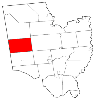
Exeter is a town in Otsego County, New York, United States. The town is located in the northern part of the county. The population was 987 at the 2010 census. It is named after the county town and cathedral city of Exeter in England.

<span class="mw-page-title-main">Hadley, New York</span> Town in New York, United States

Hadley is a town in Saratoga County, New York, United States. The population was 1,971 at the 2000 census. The town was named after Hadley, Massachusetts.

<span class="mw-page-title-main">Providence, New York</span> Town in New York, United States

Providence is a town in Saratoga County, New York, United States. The Town of Providence is on the county's western border and is northwest of Saratoga Springs. More than half the town is located within the Adirondack Park, the town also borders the Great Sacandaga Lake.

Hector is a town in the northeastern corner of Schuyler County, New York, United States. The population was 4,916 at the 2020 census. The town is named after Hector Ely, who at the time was the firstborn son of the town founders. Hector is west of Ithaca.

<span class="mw-page-title-main">Brasher, New York</span> Town in New York, United States

Brasher is a town in St. Lawrence County, New York, United States. The population was 2,512 at the 2010 census. The town is named after Philip Brasher, an original landowner.

<span class="mw-page-title-main">Clifton, New York</span> Town in New York, United States

Clifton is a town in St. Lawrence County, New York, United States. The population was 675 at the 2020 census. The town takes its name from a mining company.

<span class="mw-page-title-main">Colton, New York</span> Town in New York, United States

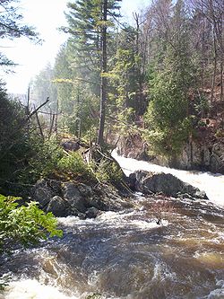
Colton is a town in St. Lawrence County, New York, United States. The population was 1,451 at the 2010 census. The town, originally named "Matildaville", is named after early settler Jesse Colton Higley.

<span class="mw-page-title-main">De Kalb, New York</span> Town in New York, United States

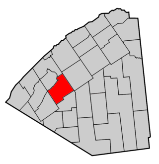
DeKalb is a town in St. Lawrence County, New York, United States. The population was 2,434 at the 2010 census. The town is named after American general Baron de Kalb, a German officer serving under George Washington.

<span class="mw-page-title-main">Hopkinton, New York</span> Town in New York, United States

Hopkinton is a town in St. Lawrence County, New York, United States. The population was 1,105 at the 2020 census and has a Population density of 5.9 square miles. The town is named for Roswell Hopkins, a pioneer settler and a government official.

<span class="mw-page-title-main">Chester, Warren County, New York</span> Town in New York, United States

Chester is a town in Warren County, New York, United States. It is part of the Glens Falls metropolitan area. The population was 3,086 at the 2020 census. The town is made up by communities of Chestertown and Pottersville.

<span class="mw-page-title-main">Plattsburgh (town), New York</span> Town in New York, United States

Plattsburgh is a town in Clinton County, New York, United States. The population was 11,886 at the 2020 census. The town is named after Zephaniah Platt, an early land owner, and it surrounds the separate and more populous city of the same name. The town is in the eastern part of the county, in the North Country region of the state of New York. The region's airport, Plattsburgh International Airport, is located in the southern part of the town.

References

  1. "2016 U.S. Gazetteer Files". United States Census Bureau. Retrieved July 5, 2017.
  2. 1 2 "Population and Housing Unit Estimates" . Retrieved June 9, 2017.
  3. 1 2 "Geographic Identifiers: 2010 Census Summary File 1 (G001), Franklin town, Franklin County, New York". American FactFinder. U.S. Census Bureau. Archived from the original on February 13, 2020. Retrieved June 13, 2016.
  4. 1 2 "National Register Information System". National Register of Historic Places . National Park Service. July 9, 2010.
  5. "Census of Population and Housing". Census.gov. Retrieved June 4, 2015.
  6. "U.S. Census website". United States Census Bureau . Retrieved January 31, 2008.