Westville, New York

Last updated

Westville, New York
USA New York location map.svg
Red pog.svg
Westville
Location within the state of New York
Coordinates: 44°55′56″N74°23′2″W / 44.93222°N 74.38389°W / 44.93222; -74.38389
Country United States
State New York
County Franklin
Government
  Type Town Council
   Town Supervisor Rod J. Lauzon (D)
   Town Clerk Ann F. Brady (D)
   Town Council
Members' List
Area
[1]
  Total34.81 sq mi (90.16 km2)
  Land34.80 sq mi (90.13 km2)
  Water0.01 sq mi (0.04 km2)
Elevation
249 ft (76 m)
Population
 (2010)
  Total1,819
  Estimate 
(2016) [2]
1,809
  Density51.99/sq mi (20.07/km2)
Time zone UTC-5 (Eastern (EST))
  Summer (DST) UTC-4 (EDT)
FIPS code 36-033-81215
GNIS feature ID0979630 [3]
Website www.townofwestvilleny.org

Westville is a town in Franklin County, New York, United States. As of the 2010 census, the town had a population of 1,819. [4] Westville is on the northern border of the county, northwest of Malone.

Contents

History

Westville Fire department Westville NY Fire Department.jpg
Westville Fire department

The area was first settled circa 1800. The town of Westville was formed from the town of Constable in 1829. The community has always been chiefly a farming community, with rich clay soils in the north and sandy soils in the southern part of the town. The Salmon River meanders through the township and was important to its early industry and its agriculture. In the 19th century, Westville was largely settled by Scottish and English people who had migrated from Vermont and other parts of New England. The only churches in the community were Protestant, the Presbyterian Church at Westville Corners and Methodist-Episcopal at Westville Center.

Around the time of the Civil War, there was an influx of French Canadians into northern New York, and some took up farming in the community. In the 19th century and early 20th century, there were several small industries in the community, a gristmill, a butter factory, a starch factory, and several sawmills. Most of these industries were located on the Salmon River. Over time,[ when? ] the industries disappeared and left only farming as the stable economic activity, as it is today.

Geography

The north town line is the international border with Canada (province of Quebec). According to the United States Census Bureau, the town has a total area of 34.8 square miles (90.2 km2), of which 0.02 square miles (0.04 km2), or 0.04%, is water. [4]

New York State Route 37 intersects New York State Route 122 at Westville Center.

The Salmon River, a tributary of the St. Lawrence River, flows northward through the town.

Demographics

Historical population
CensusPop.Note
1830 619
1840 1,02866.1%
1850 1,30126.6%
1860 1,63525.7%
1870 1,6581.4%
1880 1,6871.7%
1890 1,376−18.4%
1900 1,237−10.1%
1910 1,121−9.4%
1920 1,028−8.3%
1930 880−14.4%
1940 831−5.6%
1950 8775.5%
1960 1,28746.8%
1970 1,2990.9%
1980 1,49114.8%
1990 1,6208.7%
2000 1,82312.5%
2010 1,819−0.2%
2016 (est.)1,809 [2] −0.5%
U.S. Decennial Census [5]

As of the census [6] of 2000, there were 1,823 people, 671 households, and 503 families residing in the town. The population density was 52.4 inhabitants per square mile (20.2/km2). There were 766 housing units at an average density of 22.0 per square mile (8.5/km2). The racial makeup of the town was 96.98% White, 0.66% African American, 0.82% Native American, 0.16% Asian, and 1.37% from two or more races. Hispanic or Latino of any race were 0.82% of the population.

There were 671 households, out of which 34.4% had children under the age of 18 living with them, 61.1% were married couples living together, 7.6% had a female householder with no husband present, and 25.0% were non-families. 19.4% of all households were made up of individuals, and 8.3% had someone living alone who was 65 years of age or older. The average household size was 2.71 and the average family size was 3.07.

In the town, the population was spread out, with 26.9% under the age of 18, 7.7% from 18 to 24, 30.4% from 25 to 44, 24.8% from 45 to 64, and 10.1% who were 65 years of age or older. The median age was 36 years. For every 100 females, there were 101.7 males. For every 100 females age 18 and over, there were 100.8 males.

The median income for a household in the town was $32,452, and the median income for a family was $36,964. Males had a median income of $28,167 versus $20,291 for females. The per capita income for the town was $15,809. About 9.4% of families and 12.8% of the population were below the poverty line, including 15.7% of those under age 18 and 10.5% of those age 65 or over.

Communities and locations in Westville

Sign for Westville Center on NY 37 Westville Center Sign NY37 at NY122 West Terminus.jpg
Sign for Westville Center on NY 37

Related Research Articles

<span class="mw-page-title-main">Westville, Florida</span> Town in the state of Florida, United States

Westville is a town in Holmes County, Florida, United States. Westville is part of the Florida Panhandle in North Florida. As of the 2020 census, the town had a population of 261, down from 289 at the 2010 census. From 2010 to 2020, Westville's population growth percentage was -9.7%.

<span class="mw-page-title-main">Colesville, New York</span> Town in New York, United States

Colesville is a town in Broome County, New York, United States. The population was 4,877 at the 2020 census.

<span class="mw-page-title-main">Hinsdale, New York</span> Town in New York, United States

Hinsdale is a town in Cattaraugus County, New York, United States. The population was 2,119 at the 2020 census. The town was named after Hinsdale in New Hampshire.

Catlin is a town in Chemung County, New York, United States. The population was 2,554 at the 2020 census. The town is named after Phineas Catlin, a surveyor and public official. Catlin is in the northwestern corner of the county, northwest of Elmira. It is part of the Elmira Metropolitan Statistical Area.

<span class="mw-page-title-main">Schuyler Falls, New York</span> Town in New York, United States

Schuyler Falls is a town in Clinton County, New York, United States. The population was 5,181 at the 2010 census. The town was named after Peter Schuyler, who bought the mill on the Salmon River from Zephaniah Platt.

<span class="mw-page-title-main">Wales, New York</span> Town in New York, United States

Wales is a town in Erie County, New York, United States. The town is one of the "Southtowns" of Erie County by virtue of its position in the southeast part of the county, southeast of Buffalo. As of the 2010 census the town had a population of 3,005.

<span class="mw-page-title-main">St. Armand, New York</span> Town in New York, United States

St. Armand is a town in Essex County, New York, United States. The population was 1,446 at the 2020 census. The town was named by an early settler for Saint-Armand, Quebec, in Canada.

Bangor is a town in Franklin County, New York, United States. The population was 2,231 at the 2020 census. The town is named after Bangor in Wales.

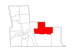
Brandon is a town in Franklin County, New York, United States. It is centrally located in the county, southwest of Malone. The town population was 577 at the 2010 census. It was named after Brandon, Vermont, by early settlers.

Constable is a town in Franklin County, New York, United States.

<span class="mw-page-title-main">Inwood, New York</span> Hamlet and census-designated place in New York, United States

Inwood is a hamlet and census-designated place (CDP) in Nassau County, on Long Island, in New York, United States. The population was 11,340 at the time of the 2020 census. It is considered part of Long Island's Five Towns area and is located within the Town of Hempstead.

<span class="mw-page-title-main">Redfield, New York</span> Town in New York, United States

Redfield is a town in Oswego County, New York, United States. The population was 550 at the 2010 census.

<span class="mw-page-title-main">Richland, New York</span> Town in New York, United States

Richland is a town in the northeastern part of Oswego County, New York, United States. The population was 5,718 at the 2010 census.

<span class="mw-page-title-main">Fine, New York</span> Town in New York, United States

Fine is a town in St. Lawrence County, New York, United States. The population was 1,512 at the 2010 census. The town is named after Judge John Fine, a businessman involved in settling the town.

<span class="mw-page-title-main">Fowler, New York</span> Town in New York, United States

Fowler is a town in St. Lawrence County, New York, United States. The population was 2,202 at the 2010 census.

<span class="mw-page-title-main">Madrid, New York</span> Town in New York, United States

Madrid is a town in St. Lawrence County, New York. The population was 1,735 at the time of the 2010 census. The town is named after the capital of Spain. Madrid is in the northern part of the county, north of Canton.

Salamanca is a town in Cattaraugus County, New York, United States. The population was 470 at the 2020 census. The name is from José de Salamanca y Mayol, Marquis of Salamanca, a major Spanish investor in the Atlantic and Great Western Railroad, a local railroad.

<span class="mw-page-title-main">Malone (village), New York</span> Village in New York, United States

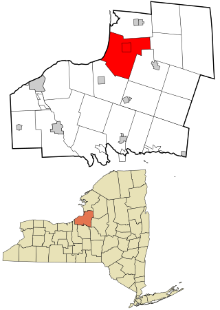
Malone is a village in, and the county seat of, Franklin County, New York, United States. Its population was 5,911 at the 2010 census. The village is in the town of Malone. It is home to a campus of North Country Community College.

Lowville is a town in Lewis County, New York, United States. The population was 4,888 at the 2020 census, down from 4,982 in 2010. The town is near the center of the county and is southeast of the city of Watertown. The town of Lowville contains a village also named Lowville, which is the county seat. The town is named after Nicholas Low, an early landowner. Low was of Dutch descent, and had emigrated with his wife and three small children from a rural village outside Amsterdam in 1778. Despite popular folk etymology, the name Lowville has nothing to do with its low elevation or the lowing cattle of the many nearby dairy farms.

<span class="mw-page-title-main">Edwards, New York</span> Town in New York, United States

Edwards is a town in St. Lawrence County, New York, United States. The population was 1,156 at the 2010 census. The village is named after Edward McCormack, brother of the founder.

References

  1. "2016 U.S. Gazetteer Files". United States Census Bureau. Retrieved July 5, 2017.
  2. 1 2 "Population and Housing Unit Estimates" . Retrieved June 9, 2017.
  3. "US Board on Geographic Names". United States Geological Survey. October 25, 2007. Retrieved January 31, 2008.
  4. 1 2 "Geographic Identifiers: 2010 Census Summary File 1 (G001), Westville town, Franklin County, New York". American FactFinder. U.S. Census Bureau. Archived from the original on February 13, 2020. Retrieved June 15, 2016.
  5. "Census of Population and Housing". Census.gov. Retrieved June 4, 2015.
  6. "U.S. Census website". United States Census Bureau . Retrieved January 31, 2008.