Dinnington, South Yorkshire

Last updated

Dinnington
St. Leonard's Church Dinnington - geograph.org.uk - 1087826.jpg
South Yorkshire UK location map.svg
Red pog.svg
Dinnington
Location within South Yorkshire
Population9,077 (2011 census) [1]
OS grid reference SK5386
  London 135 mi (217 km)  SSE
Civil parish
  • Dinnington St John's
Metropolitan borough
Metropolitan county
Region
Country England
Sovereign state United Kingdom
Post town SHEFFIELD
Postcode district S25
Dialling code 01909
Police South Yorkshire
Fire South Yorkshire
Ambulance Yorkshire
UK Parliament
List of places
UK
England
Yorkshire
53°22′00″N1°12′00″W / 53.3667°N 1.200°W / 53.3667; -1.200

Dinnington is a town in the civil parish of Dinnington St John's, in the Metropolitan Borough of Rotherham, in South Yorkshire, England. It is near to the towns of Worksop and Rotherham and cities of Sheffield and Doncaster.

Contents

Historically part of the West Riding of Yorkshire, Dinnington is the principal settlement in the civil parish of Dinnington St John's, which also includes the small satellite hamlets of Throapham and St John's. The Dinnington St John's parish is the most populous constituent of the St John's ward, which also includes the parishes of Laughton-en-le-Morthen, Firbeck, Letwell and Gildingwells. In 2001 this ward had a population of 11,476, with Dinnington St John's itself making up 9,161 of that figure. [2] The population of the ward at the 2011 Census had increased to 12,517. [3] Dinnington is about 330 feet (101 m) above sea level.

History

Excavations show Dinnington to have been inhabited since at least Neolithic times, and it has been suggested that the settlement takes its name from a local barrow, though a more traditional interpretation of "Dinnington" would be "Dunn's Farmstead", or "Town of Dunn's People".

Dinnington was originally a small, isolated farming community, based around the New Road area of the town. Quarrying in the area helped expand the population, but it was the sinking of the Dinnington Main Colliery in 1905 that led to the real growth of the settlement. The census of 1911 shows a twenty-fold increase in population of the parish since 1901, from 250 to 5,000. In 1951 the parish had a population of 7,053. [4]

The coal miners initially lived in a prefabricated shanty town in Laughton Common, colloquially known as "Tin Town" or "White City" but later moved into colliery-built terrace houses around the central shopping area of Laughton Road.

Dinnington was an ancient parish which became a civil parish in 1866. On 1 April 1954 the civil parish was abolished and merged with the civil parish of St Johns with Throapham, to form the civil parish of Dinnington St John's. [5]

Dinnington continued to expand throughout the 20th century, largely through the growth of commuter living that followed the Second World War. As the housing estates spread, Dinnington began to merge seamlessly into the neighbouring settlements of Throapham and North Anston. The result is a 2.2 miles (3.5 km) strip of urban development that mainly acts as a commuter base for Sheffield, Rotherham and Worksop, although with the closure of coal mines and steel mills, the area saw a rapid decline in the late 1980s and early 1990s and despite steady growth, still boasted the highest level of unemployment in the UK in 2001. [6]

Dinnington Colliery was closed in 1992. This damaged the local community, and had a large negative impact on the local economy with initial job losses and knock-on effect closures to local business. In 2019 Conservative Alexander Stafford was voted as the MP for the Rother Valley constituency, of which Dinnington is a part, many in Dinnington were understandably unhappy given the towns history with Conservative party. [7] In 2023 Councillor Charlie Wooding was removed from his position after it was revealed that he had failed to attend council meeting while continuing to claim his wages, causing outrage in the town, [8] a by-election was triggered and local resident Julia Hall was elected to take his place [9]

In 1995, Dinnington was featured in an episode of the BBC1 TV documentary series Everyman , entitled Simon's Cross. The programme described the life of Dinnington parish priest, the Rev Simon Bailey, [10] detailing his life, work and reflections while living with AIDS, and the way members of the parish of Dinnington came to terms with it and supported him. Scarlet Ribbons: A Priest with AIDS, an account of his story, was written by Simon Bailey's sister, Rosemary Bailey and published by Serpent's Tail in 1997. In 2003, Dinnington was declared a town as part of an attempt to attract more investment and improve the local economy.

Dinnington, in the fog Dinnington Fog.jpg
Dinnington, in the fog

Controversy arose in the village over plans to redevelop the Miners' Welfare. The Welfare buildings and sports fields were provided originally for the miners at the local colliery by CISWO in 1926. The property had been leased to Rotherham Borough Council and was used for Safe@Start programmes up until 2007. It has remained empty since that date and has been subject to vandalism and lack of repairs. Controversy over development resulted in the formation of a local residents' group opposing the development plans and asking for the regeneration of the site as an amenity for local people. [11]

Dinnington had a population of 9,077 in the 2011 census, which makes it slightly larger than Wath-upon-Dearne. Here are the three areas known as Dinnington:

Community

Dinnington's two further education establishments are Rotherham College of Arts and Technology and the sixth form at Dinnington High School.

Dinnington's high street and main shopping areas include Tesco, Savers, Domino's and Aldi stores, as well as small traders, including several take-aways, a haberdashery and an indoor market.

Manor Motorsport, known in Formula One as Virgin Racing from 2010 to 2011, Marussia F1 from 2012 to 2014 and currently known as Manor Marussia F1 were once based in the town.

The town's only football club Dinnington Town F.C. play at Phoenix Park, situated at the Dinnington Resource Centre.

Media

Local news and television programmes are provided by BBC Yorkshire and ITV Yorkshire. Television signals are received from the Emley Moor TV transmitter. [12]

Local radio stations are BBC Radio Sheffield, Heart Yorkshire, Greatest Hits Radio South Yorkshire, Hallam FM, and Redload FM, a community based radio station that broadcast from Rotherham. [13]

The town is served by these local newspapers:

Transport

Dinnington Interchange
General information
LocationConstable Lane, Dinnington town centre
Rotherham (S25 2AG)
England
Owned by South Yorkshire Passenger Transport Executive
Operated by Travel South Yorkshire
Bus stands3
Bus operators First South Yorkshire, Stagecoach East Midlands, TM Travel
Construction
ParkingNo
Bicycle facilitiesYes
AccessibleYes

Dinnington Interchange is a small bus station operated by Travel South Yorkshire in Dinnington town centre. Opened next to Dinnington Market in the late 1990s, replacing on-street bus stops on the congested Laughton Road, the Interchange consists of three bus stands with a covered indoor waiting area, toilets and a staffed ticket office at peak times. Dinnington Interchange provides a local hub for bus services between Sheffield, Rotherham and Worksop.

As of January 2021, the stand allocation is:

StandRouteDestination
A119, 19a Worksop National Rail logo.svg BSicon BUS2.svg     
A219, 19a Rotherham National Rail logo.svg Supertram generic logo.PNG BSicon BUS2.svg     
A320 Rotherham National Rail logo.svg Supertram generic logo.PNG BSicon BUS2.svg     
216 Laughton Common     
X5 Sheffield National Rail logo.svg Supertram generic logo.PNG BSicon BUS2.svg     

See also

Related Research Articles

Anston is a civil parish in South Yorkshire, England, formally known as North and South Anston. The parish of Anston consists of the settlements of North Anston and South Anston, divided by the Anston Brook.

<span class="mw-page-title-main">Bassetlaw District</span> District of Nottinghamshire, England

Bassetlaw is a local government district in north Nottinghamshire, England. Its council is based in the town of Worksop; the other towns in the district are Retford, Tuxford and Harworth Bircotes. The district also contains numerous villages and surrounding rural areas.

<span class="mw-page-title-main">Hemsworth</span> Town and civil parish in West Yorkshire, England

Hemsworth is a town and civil parish in the City of Wakefield, West Yorkshire, England. Historically within the West Riding of Yorkshire and had a population of 13,311 at the 2001 census, with it increasing to 13,533 at the 2011 Census.

<span class="mw-page-title-main">Metropolitan Borough of Rotherham</span> Metropolitan borough in South Yorkshire, England

The Metropolitan Borough of Rotherham is a metropolitan borough of South Yorkshire, England. It is named after its main settlement of Rotherham. The wider borough spans a larger area and covers the outlying towns of Maltby, Swinton, Wath-upon-Dearne, Dinnington. As well as the villages of Rawmarsh and Laughton. A large valley spans the entire borough and is referred to as the "Rother Valley".

<span class="mw-page-title-main">Woodsetts</span> Village and civil parish in South Yorkshire, England

Woodsetts is a village and civil parish in the Metropolitan Borough of Rotherham in South Yorkshire, England, on the border with Nottinghamshire. It lies between the towns of Dinnington and Worksop at an elevation of around 60 metres above sea level, and has a population of 1,802 reducing to 1,746 at the 2011 Census.

<span class="mw-page-title-main">Maltby, South Yorkshire</span> Town and civil parish in South Yorkshire, England

Maltby is a former mining town and civil parish in the Metropolitan Borough of Rotherham, South Yorkshire, England. It was historically in the West Riding of Yorkshire. It is located 6 miles (10 km) east of Rotherham and 10 miles (16 km) north-east of Sheffield. It forms a continuous urban area with Hellaby, separated from the rest of Rotherham by the M18 motorway. It had a population of 16,688 at the 2011 Census.

<span class="mw-page-title-main">Mexborough</span> Town in South Yorkshire, England

Mexborough is a town in the City of Doncaster in South Yorkshire, England. Situated between Manvers and Denaby Main, it lies on the River Don close to where it joins the River Dearne, and the A6023 road runs through the town. It is contiguous with the town of Swinton which is directly to the southwest immediately across the railway and Conisbrough to the east.

<span class="mw-page-title-main">Normanton, West Yorkshire</span> Town and civil parish in West Yorkshire, England

Normanton is a town and civil parish in the City of Wakefield in West Yorkshire, England. It is north-east of Wakefield and south-west of Castleford. The civil parish extends west and north to the River Calder, and includes the large village of Altofts. At the time of the 2011 Census, the population of the civil parish was 20,872.

Ecclesfield is a village and civil parish in the City of Sheffield, South Yorkshire, England, about 4 miles (6 km) north of Sheffield City Centre. Ecclesfield civil parish had a population of 32,073 at the 2011 Census. Ecclesfield wards of the City of Sheffield had a population of 35,994 in 2011. The population of Ecclesfield village stood at 7,163 in the most recent census.

<span class="mw-page-title-main">Wath upon Dearne</span> Town in South Yorkshire, England

Wath upon Dearne is a town south of the River Dearne in the Metropolitan Borough of Rotherham, South Yorkshire, England, 5 miles (8 km) north of Rotherham and almost midway between Barnsley and Doncaster. It had a population of 11,816 at the 2011 census. It is twinned with Saint-Jean-de-Bournay in France.

<span class="mw-page-title-main">Wickersley</span> Village and civil parish in South Yorkshire, England

Wickersley is a village and civil parish in the Metropolitan Borough of Rotherham in South Yorkshire, England, situated 3 miles (5 km) from the centre of Rotherham. The area is very near to road junctions for the M1, M18 and A1(M). It is home to the secondary school and sixth form, Wickersley School and Sports College.

Kiveton Park was a rural district in the West Riding of Yorkshire from 1894 to 1974.

<span class="mw-page-title-main">Laughton en le Morthen</span> Village and civil parish in South Yorkshire, England

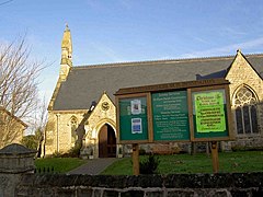
Laughton en le Morthen is a village and civil parish in the Metropolitan Borough of Rotherham lying to the south of Rotherham, South Yorkshire, England, and its main attraction is the All Saints Church with its tower and spire of 185 feet. The village had a population of 1,241 at the 2011 Census. The parish also includes the hamlets of Carr, Slade Hooton and Brookhouse.

<span class="mw-page-title-main">Sheffield & Hallamshire Senior Cup</span> Football tournament

The Sheffield & Hallamshire Senior Cup is a county cup competition involving teams within the Sheffield and Hallamshire County Football Association. Originally named the Sheffield Challenge Cup, it is the 5th oldest surviving cup competition in the world, after the FA Cup (1871–72), the Scottish FA Cup (1873–74), the East of Scotland Shield (1875–76) and the Birmingham Senior Cup (1876-77).

Thurcroft is a village and civil parish situated south-east of Rotherham in the Metropolitan Borough of Rotherham in South Yorkshire, England. From 1902 to 1991, it was a mining community. It has a population of 5,296, increasing to 6,900 at the 2011 Census.

<span class="mw-page-title-main">Throapham</span> Hamlet in South Yorkshire, England

Throapham is a hamlet in the Metropolitan Borough of Rotherham in South Yorkshire, England.

The 1949–50 Yorkshire Football League was the 24th season in the history of the Yorkshire Football League. A new Second Division was formed for this season.

<span class="mw-page-title-main">Slade Hooton</span> Hamet in South Yorkshire, England

Slade Hooton is a hamlet in the Metropolitan Borough of Rotherham, in South Yorkshire, England. Historically in the West Riding of Yorkshire, the hamlet was moved into South Yorkshire in April 1974.

References

  1. "Local statistics – Office for National Statistics". www.neighbourhood.statistics.gov.uk. Archived from the original on 10 January 2017. Retrieved 6 February 2016.
  2. Office for National Statistics : Census 2001 : Parish Headcounts : Rotherham Archived 13 June 2011 at the Wayback Machine Retrieved 28 August 2009
  3. "Rotherham MBC Ward population 2011". Neighbourhood Statistics. Office for National Statistics. Retrieved 9 March 2016.
  4. "Dinnington CP/AP through time – Population Statistics – Total Population". www.visionofbritain.org.uk.
  5. "Dinnington CP/AP through time – Census tables with data for the Parish-level Unit". www.visionofbritain.org.uk.
  6. "Unemployment: UK National Statistics Publication Hub". Archived from the original on 19 July 2012.
  7. "General election results: First ever Tory MP for Rother Valley" . Retrieved 26 January 2024.
  8. "Suspended Tory councillor steps downs and triggers by-election in Dinnington" . Retrieved 26 January 2024.
  9. "Councillor details – Councillor Julia Hall". Rotherham Council – Meetings, agendas and minutes. 26 January 2024. Retrieved 26 January 2024.
  10. "Simon's Cross". 15 January 1995 via IMDb.
  11. "Dinnington welfare means so much to so many". Dinnington Today. Retrieved 1 March 2011.
  12. "Emley Moor (Kirklees, England) Full Freeview transmitter". UK Free TV. 1 May 2004. Retrieved 24 October 2023.
  13. "Redload FM" . Retrieved 24 October 2023.
  14. "Rotherham Advertiser". British Papers. 15 October 2013. Retrieved 24 October 2023.
  15. "Worksop Guardian". British Papers. 27 March 2014. Retrieved 24 October 2023.