The Hoojah Branch Site (9RA34) is an archaeological site in Rabun County, Georgia that had periods of occupation from the Archaic period to the Mississippian period. It is believed to be a platform mound similar to others across North Georgia built by peoples of the South Appalachian Mississippian culture that flourished in the Southeastern United States from approximately the years 1000 to 1600. The site is located about one mile east of Dillard, Georgia and is in the Chattahoochee National Forest and may have had a connection to the Qualla mound complexes in southwestern North Carolina. The site was listed on the National Register of Historic Places on January 24, 1973 as reference number 86003667

Town Creek Indian Mound is a prehistoric Native American archaeological site located near present-day Mount Gilead, Montgomery County, North Carolina, in the United States. The site, whose main features are a platform mound with a surrounding village and wooden defensive palisade, was built by the Pee Dee, a South Appalachian Mississippian culture people that developed in the region as early as 980 CE. They thrived in the Pee Dee River region of North and South Carolina during the Pre-Columbian era. The Town Creek site was an important ceremonial site occupied from about 1150—1400 CE. It was abandoned for unknown reasons. It is the only ceremonial mound and village center of the Pee Dee located within North Carolina.

The Deptford culture was an archaeological culture in southeastern North America characterized by the appearance of elaborate ceremonial complexes, increasing social and political complexity, mound burial, permanent settlements, population growth, and an increasing reliance on cultigens.

This list includes properties and districts listed on the National Register of Historic Places in Rockingham County, North Carolina. Click the "Map of all coordinates" link to the right to view an online map of all properties and districts with latitude and longitude coordinates in the table below.

This list includes properties and districts listed on the National Register of Historic Places in Macon County, North Carolina. Click the "Map of all coordinates" link to the right to view a Google map of all properties and districts with latitude and longitude coordinates in the table below.
This list includes properties and districts listed on the National Register of Historic Places in Randolph County, North Carolina. Click the "Map of all coordinates" link to the right to view a Google map of all properties and districts with latitude and longitude coordinates in the table below.
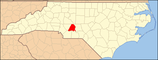
This list includes properties and districts listed on the National Register of Historic Places in Stanly County, North Carolina. Click the "Map of all coordinates" link to the right to view an online map of all properties and districts with latitude and longitude coordinates in the table below.

This list includes properties and districts listed on the National Register of Historic Places in Swain County, North Carolina. Click the "Map of all coordinates" link to the right to view an online map of all properties and districts with latitude and longitude coordinates in the table below.

This list includes properties and districts listed on the National Register of Historic Places in Yadkin County, North Carolina. Click the "Map of all coordinates" link to the right to view a Google map of all properties and districts with latitude and longitude coordinates in the table below.
Garden Creek site is an archaeological site located 24 miles (39 km) west of Asheville, North Carolina in Haywood County, on the south side of the Pigeon River and near the confluence of its tributary Garden Creek. It is near modern Canton and the Pisgah National Forest. The earliest human occupation at the site dates to 8000 BCE. The 12-acre site features remains of two villages (31Hw7) occupied first in the Woodland period and, most prominently, in the Pisgah phase associated with the South Appalachian Mississippian culture. A total of four earthwork mounds have been found at the site; three have been excavated.

The LoDaisKa site is a prominent archaeological site in the U.S. state of Colorado, located within a rockshelter near Morrison. The rockshelter was first inhabited by people of the Archaic through the Middle Ceramic period, generally spanning 3000 BC to 1000 AD.

Epsilon II is a significant archaeological site on the shores of Monroe Lake in southeastern Monroe County, Indiana, United States. One of the largest preserved sites from its time period in the region, it has been designated a historic site.
Upper Saratown, also known as Upper Sauratown, is an archaeological site from the Late Saratown phase in North Carolina. The site is located on the Dan River in Stokes County and was occupied by the Sara people. Excavations were conducted at the site each summer from 1972 through 1981 by archaeologists from the Research Laboratories of Anthropology at the University of North Carolina. Of all the Late Saratown sites, it is the most thoroughly excavated.

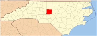
This list includes properties and districts listed on the National Register of Historic Places in Montgomery County, North Carolina. Click the "Map of all coordinates" link to the right to view an online map of all properties and districts with latitude and longitude coordinates in the table below.

The Magic Mountain site is an Archaic and Woodland village site in Jefferson County, Colorado dating from 4999 BC to 1000 AD. The site was added to the National Register of Historic Places in 1980.

Judaculla Rock is a curvilinear-shaped outcrop of soapstone known for its ancient carvings and petroglyphs. The archaeological site is located on a 0.85-acre rectangular-shaped property, now owned by Jackson County. It is approximately 60 meters east of Caney Fork Creek, a major branch of the northwestward-trending Tuckasegee River in the mountains of Western North Carolina.

The Rockhouse Cliffs Rockshelters are a pair of rockshelters in the far southern region of the U.S. state of Indiana. Located amid broken terrain in the Hoosier National Forest, the shelters may have been inhabited for more than ten thousand years by peoples ranging from the Early Archaic period until the twentieth century. As a result of their extensive occupation and their remote location, they are important and well-preserved archaeological sites and have been named a historic site.
Lower Sauratown Plantation includes the remnants of a historic plantation and archaeological site located near Eden, Rockingham County, North Carolina. The plantation remnants include a plantation office building, a mid-19th century brick dwelling house, the Brodnax family cemetery, the remains of an extensive boxwood garden, and numerous below-grade foundations. The office and dwelling house were restored in 1983. Site 31RK1 is located on the Lower Sauratown Plantation and includes the remains of a large 17th-century Indian village of the Saura tribe. Lower Sauratown Plantation was the boyhood home of Governor Robert Broadnax Glenn, the adopted son of Dr. Edward T. Brodnax.
Donnaha Site is a historic archaeological site located on the banks of the Yadkin River near East Bend, Yadkin County, North Carolina. The site includes well-preserved organic remains from a village occupied between ca. A.D. 1000 and A.D. 1500.
The Lowder's Ferry site, also known as 31St7, is an archaeological site with remains from the Archaic period in North America located in Stanly County, North Carolina. It lies on the west bank of the Yadkin River across from its confluence with the Uwharrie River.


