
Phoenix is the capital and most populous city of the U.S. state of Arizona, with 1,608,139 residents as of 2020. It is the fifth-most populous city in the United States and the most populous state capital in the country.

Coconino County is a county in the north-central part of the U.S. state of Arizona. Its population was 145,101 at the 2020 census. The county seat is Flagstaff. The county takes its name from Cohonino, a name applied to the Havasupai people. It is the second-largest county by area in the contiguous United States, behind San Bernardino County, California. It has 18,661 sq mi (48,300 km2), or 16.4% of Arizona's total area, and is larger than the nine smallest states in the U.S.

Maricopa County is in the south-central part of the U.S. state of Arizona. As of the 2020 census the population was 4,420,568, or about 62% of the state's total, making it the fourth-most populous county in the United States and the most populous county in Arizona, and making Arizona one of the nation's most centralized states. The county seat is Phoenix, the state capital and fifth-most populous city in the United States.

Rogers County is located in the northeastern part of the U.S. state of Oklahoma. As of the 2020 census, the population was 95,240, making it the sixth-most populous county in Oklahoma. The county seat is Claremore. Rogers County is included in the Tulsa, OK metropolitan statistical area.

Dickinson County is a county located in the U.S. state of Iowa. As of the 2020 census, the population was 17,703. The county seat is Spirit Lake. The county was organized in 1857 and is named in honor of Daniel S. Dickinson, a U.S. Senator for New York.

Salome is an unincorporated community and census-designated place (CDP) in La Paz County, Arizona, United States. The population was 1,162 at the 2020 census. It was established in 1904 by Dick Wick Hall, Ernest Hall and Charles Pratt, and was named after Pratt's wife, Grace Salome Pratt.

Florence is a town in Pinal County, Arizona, United States. Florence, which is the county seat of Pinal County, is one of the oldest towns in that county and includes a National Historic District with over 25 buildings listed on the National Register of Historic Places. The population of Florence was 26,785 at the 2020 census.

Burlington is a town in Middlesex County, Massachusetts, United States. The population was 26,377 at the 2020 census.
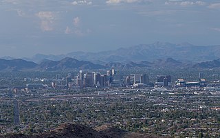
The Phoenix metropolitan area, also known as the Valley of the Sun, the Salt River Valley, metro Phoenix, or The Valley, is the largest metropolitan statistical area in the Southwestern United States, with its largest principal city being the city of Phoenix. It includes much of central Arizona. The United States Office of Management and Budget designates the area as the Phoenix–Mesa–Chandler Metropolitan Statistical Area (MSA), defining it as Maricopa and Pinal counties. It anchors the Arizona Sun Corridor megaregion along with the second-most populous metropolitan area in the state, the Tucson metropolitan area. The gross domestic product of the Phoenix metropolitan area was $255 billion in 2018, 16th highest amongst metro areas in the United States.

Aguila is an unincorporated community and census-designated place (CDP) in Maricopa County, Arizona, United States. It is located on U.S. Route 60, 25 miles (40 km) west of Wickenburg and 22 miles (35 km) northeast of Wenden. Major economic activities include cantaloupe farming and formerly included mining. It uses the same street numbering system as Phoenix. As of the 2020 census, the population of Aguila was 565, down from 798 in 2010.

Komatke is a census-designated place in Maricopa County, Arizona, United States. The area currently comprising the census-designated place had a population of 1,013 at the 2020 census, up from 821 at the 2010 census. It is located within the Gila River Indian Community. Its name refers to the Sierra Estrella mountain range, which rises just to the southwest of Komatke.

As of the 2020 United States census, Arizona had a population of 7,151,502.

Arizona is a landlocked state in the Southwestern region of the United States. Arizona is part of the Four Corners region with Utah to the north, Colorado to the northeast, and New Mexico to the east; its other neighboring states are Nevada to the northwest, California to the west and the Mexican states of Sonora and Baja California to the south and southwest. It is the 6th-largest and the 14th-most-populous of the 50 states. Its capital and largest city is Phoenix.

The Mountain states form one of the nine geographic divisions of the United States that are officially recognized by the United States Census Bureau. It is a subregion of the Western United States.

Gila Crossing is a census-designated place (CDP) in Maricopa County, Arizona, United States, within the Gila River Indian Community south of Komatke. The population was 636 at the 2020 census.

Kaka is a census-designated place (CDP) in Maricopa County, Arizona, United States, located in the Tohono O'odham Nation. The population was 83 at the 2020 census, down from 141 at the 2010 census.

Maricopa Colony is a census-designated place (CDP) in Maricopa County, Arizona, United States, located in the federally recognized Gila River Indian Community. The population was 854 at the 2020 census, up from 709 at the 2010 census. It is located on the southern side of the Phoenix metropolitan area, around Baseline Road and 83rd Avenue.

Cactus Forest is a census-designated place (CDP) in Pinal County, Arizona, United States. The population was 594 at the 2010 census.

Campo Bonito is a census-designated place (CDP) in Pinal County, Arizona, United States. The population was 74 at the 2010 census.


