Mountainaire, Arizona

Last updated

Mountainaire, Arizona
CDP
Mountainaire AZ Fire Dept.jpg
Mountainaire Fire Station
Coconino County incorporated areas Mountainaire highlighted.svg
Location in Coconino County and the state of Arizona
Usa edcp location map.svg
Red pog.svg
Mountainaire, Arizona
Location in the United States
Coordinates: 35°05′30″N111°38′57″W / 35.09167°N 111.64917°W / 35.09167; -111.64917
CountryUnited States
State Arizona
County Coconino
Area
[1]
  Total10.21 sq mi (26.43 km2)
  Land10.20 sq mi (26.43 km2)
  Water0.00 sq mi (0.01 km2)
Elevation
[2]
6,952 ft (2,119 m)
Population
 (2020)
  Total1,068
  Density104.66/sq mi (40.41/km2)
Time zone UTC-7 (MST)
ZIP code
86005
Area code 928
FIPS code 04-47820
GNIS feature ID2408886 [2]

Mountainaire is a census-designated place (CDP) in Coconino County, Arizona, United States. The population was 1,119 at the 2010 census. [3]

Contents

Geography

According to the United States Census Bureau, the CDP has a total area of 10.2 square miles (26.5 km2), all land.

Mountainaire CDP includes Kachina Hills and Mountainaire subdivisions, and nearby areas. [4]

Climate

This region experiences warm (but not hot) and dry summers, with no average monthly temperatures above 71.6 °F. According to the Köppen Climate Classification system, Mountainaire has a warm-summer Mediterranean climate, abbreviated "Csb" on climate maps. [5]

Demographics

Historical population
CensusPop.Note
2020 1,068
U.S. Decennial Census [6]

As of the census [7] of 2000, there were 1,014 people, 417 households, and 246 families living in the CDP. The population density was 99.2 inhabitants per square mile (38.3/km2). There were 556 housing units at an average density of 54.4 per square mile (21.0/km2). The racial makeup of the CDP was 86.1% White, 0.3% Black or African American, 7.7% Native American, 0.3% Asian, 0.1% Pacific Islander, 3.1% from other races, and 2.5% from two or more races. 6.6% of the population were Hispanic or Latino of any race.

There were 417 households, out of which 31.4% had children under the age of 18 living with them, 46.8% were married couples living together, 8.2% had a female householder with no husband present, and 41.0% were non-families. 26.6% of all households were made up of individuals, and 4.1% had someone living alone who was 65 years of age or older. The average household size was 2.43 and the average family size was 3.04.

In the CDP, the age distribution of the population shows 24.7% under the age of 18, 8.5% from 18 to 24, 39.6% from 25 to 44, 23.5% from 45 to 64, and 3.7% who were 65 years of age or older. The median age was 33 years. For every 100 females, there were 110.4 males. For every 100 females age 18 and over, there were 107.6 males.

The median income for a household in the CDP was $41,250, and the median income for a family was $49,355. Males had a median income of $32,406 versus $27,125 for females. The per capita income for the CDP was $23,625. About 5.3% of families and 7.4% of the population were below the poverty line, including 10.9% of those under age 18 and none of those age 65 or over.

Related Research Articles

<span class="mw-page-title-main">Lukachukai, Arizona</span> CDP in Apache County, Arizona

Lukachukai is a census-designated place (CDP) in Apache County, Arizona, United States. The population was 1,701 at the 2010 census. It is within the Navajo Nation.

<span class="mw-page-title-main">McNary, Arizona</span> CDP in Apache and Navajo Counties, Arizona

McNary is a census-designated place (CDP) in Apache and Navajo counties in the U.S. state of Arizona, on the Fort Apache Indian Reservation. The population was 528 at the 2010 census.

<span class="mw-page-title-main">Teec Nos Pos, Arizona</span> Census-designated place in Arizona, United States

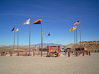
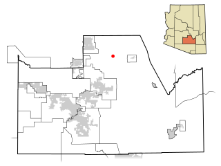
Teec Nos Pos is a census-designated place (CDP) in Apache County, Arizona, United States. The population was 507 at the 2020 census. It is the western terminus of U.S. Route 64.

<span class="mw-page-title-main">Sierra Vista Southeast, Arizona</span> CDP in Cochise County, Arizona

Sierra Vista Southeast, often referred to as Hereford or Nicksville, is a census-designated place (CDP) in Cochise County, Arizona, United States. The population was 14,797 at the 2010 census. It includes the neighborhoods Ramsey Canyon, and Sierra Vista Estates within its boundaries.

<span class="mw-page-title-main">Kachina Village, Arizona</span> CDP in Coconino County, Arizona

Kachina Village is a census-designated place (CDP) in Coconino County, Arizona, United States. The population was 2,622 at the 2010 census. Kachina Village is primarily a bedroom community for Flagstaff.

<span class="mw-page-title-main">Kaibito, Arizona</span> CDP in Coconino County, Arizona

Kaibeto is a census-designated place (CDP) in Coconino County, Arizona, United States. The population was 1,522 at the 2010 census.

<span class="mw-page-title-main">LeChee, Arizona</span> CDP in Coconino County, Arizona

LeChee is a census-designated place (CDP) in Coconino County, Arizona, United States. The population was 1,443 at the 2010 census.

<span class="mw-page-title-main">Winslow West, Arizona</span> CDP in Coconino County, Arizona

Winslow West is a census-designated place (CDP) in Coconino and Navajo counties in Arizona, United States. The population was 438 at the 2010 census. The entire community is off-reservation trust land belonging to the Hopi Tribe of Arizona. It lies just west of the city of Winslow, and is more than 50 km (31 mi) south of the main Hopi Reservation.

<span class="mw-page-title-main">Claypool, Arizona</span> CDP in Gila County, Arizona

Claypool is a census-designated place (CDP) in Gila County, Arizona, United States. The population was 1,538 at the 2010 census, down from 1,794 at the 2000 census. It was named after W. D. Claypool, a member of both the State House of Representatives and State Senate in the 1910s and 1920s.

<span class="mw-page-title-main">Cibola, Arizona</span> CDP in La Paz County, Arizona

Cibola is a census-designated place (CDP) in La Paz County, Arizona, United States. The population was 250 at the 2010 census, up from 172 in 2000. It is named for the famed city of gold of the same name.

<span class="mw-page-title-main">Sun Lakes, Arizona</span> CDP in Maricopa County, Arizona

Sun Lakes is an unincorporated community and census-designated place (CDP) in Maricopa County, Arizona, United States. The population was 14,868 at the 2020 census. Sun Lakes is an active adult community comprising five country club communities in three homeowner associations. These include the gated communities of Oakwood and IronWood (IronOaks), the gated and non-gated communities of Palo Verde and Cottonwood, and the non-gated community of Sun Lakes 1. Sun Lakes is a master-planned community developed by Robson Communities.

<span class="mw-page-title-main">Whiteriver, Arizona</span> Census designated place in Arizona, United States

Whiteriver is a census-designated place (CDP) located on the Fort Apache Indian Reservation in Navajo County, Arizona, United States. The population was 4,104 at the 2010 census, making it the largest settlement on the Reservation.

<span class="mw-page-title-main">Avra Valley, Arizona</span> CDP in Pima County, Arizona

Avra Valley is a census-designated place (CDP) in Pima County, Arizona, United States. The population was 6,050 at the 2010 census, up from 5,038 in 2000.

<span class="mw-page-title-main">Littletown, Arizona</span> CDP in Pima County, Arizona

Littletown was a census-designated place (CDP) in Pima County, Arizona, United States. The population was 1,010 at the 2000 census. The area was annexed into Tucson in 2017.

<span class="mw-page-title-main">Summit, Arizona</span> CDP in Pima County, Arizona

Summit is a census-designated place (CDP) in Pima County, Arizona, United States. The population was 3,702 at the 2000 census.

<span class="mw-page-title-main">Queen Valley, Arizona</span> CPD in Pinal County, Arizona

Queen Valley is a census-designated place (CDP) in north central Pinal County, Arizona, United States. The population was 820 at the 2000 census.

<span class="mw-page-title-main">Meadow Valley, California</span> Census-designated place in California, United States

Meadow Valley is a census-designated place (CDP) in Plumas County, California, United States. The population was 453 at the 2020 census, down from 464 at the 2010 census.

<span class="mw-page-title-main">Bluewater, California</span> Census-designated place in California, United States

Bluewater is a census-designated place (CDP) in San Bernardino County, California, United States. The population was 172 at the 2010 census, down from 265 at the 2000 census.

<span class="mw-page-title-main">Affton, Missouri</span> Census-designated place in Missouri, United States

Affton is a census-designated place (CDP) in south St. Louis County, Missouri, United States, near St. Louis. The population was 20,417 at the 2020 United States Census.

<span class="mw-page-title-main">Harper, Texas</span> Census-designated place in Texas, United States

Harper is an unincorporated community and census-designated place (CDP), located 23 miles (37 km) west of Fredericksburg on U.S. Highway 290, in Gillespie County, in the U.S. state of Texas. The population was 1,192 at the 2010 census.

References

  1. "2020 U.S. Gazetteer Files". United States Census Bureau. Retrieved October 29, 2021.
  2. 1 2 U.S. Geological Survey Geographic Names Information System: Mountainaire, Arizona
  3. "Profile of General Population and Housing Characteristics: 2010 Demographic Profile Data (DP-1): Mountainaire CDP, Arizona". United States Census Bureau . Retrieved December 8, 2011.
  4. "Map of Mountainaire CDP". Archived from the original on February 16, 2020. Retrieved March 29, 2020.
  5. Climate Summary for Mountainaire, Arizona
  6. "Census of Population and Housing". Census.gov. Retrieved June 4, 2016.
  7. "U.S. Census website". United States Census Bureau . Retrieved January 31, 2008.