Parks, Arizona

Last updated

Parks, Arizona
CDP
Spring Valley Cabin, AZ.jpg
Historic Spring Valley Cabin near Parks [2]
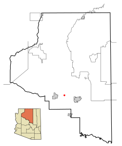
Coconino County incorporated areas Parks highlighted.svg
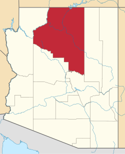
Location in Coconino County and the state of Arizona
Usa edcp location map.svg
Red pog.svg
Parks, Arizona
Location in the United States
Coordinates: 35°17′29″N111°57′32″W / 35.29139°N 111.95889°W / 35.29139; -111.95889
CountryUnited States
State Arizona
County Coconino
Area
[3]
  Total169.92 sq mi (440.09 km2)
  Land169.90 sq mi (440.03 km2)
  Water0.02 sq mi (0.06 km2)
Elevation
[4]
7,304 ft (2,226 m)
Population
 (2020)
  Total1,382
  Density8.13/sq mi (3.14/km2)
Time zone UTC-7 (MST)
ZIP code
86018
Area code 928
FIPS code 04-53350
GNIS feature ID2409033 [4]
Website www.city-data.com/city/Parks-Arizona.html

Parks is a census-designated place (CDP) in Coconino County, Arizona, United States. The population was 1,188 at the 2010 census. [5]

Contents

Geography

According to the United States Census Bureau, the CDP has a total area of 172.4 square miles (446.4 km2), of which 172.3 square miles (446.3 km2) is land and 0.02 square miles (0.06 km2), or 0.01%, is water. [6]

Demographics

Historical population
CensusPop.Note
2020 1,382
U.S. Decennial Census [7]

As of the census [8] of 2000, there were 1,137 people, 462 households, and 342 families residing in the CDP. The population density was 6.6 inhabitants per square mile (2.5/km2). There were 918 housing units at an average density of 5.3 per square mile (2.0/km2). The racial makeup of the CDP was 93.7% White, 0.4% Black or African American, 0.7% Native American, 0.4% Asian, 0.5% Pacific Islander, 1.8% from other races, and 2.6% from two or more races. 5.2% of the population were Hispanic or Latino of any race.

There were 462 households, out of which 29.2% had children under the age of 18 living with them, 63.6% were married couples living together, 5.8% had a female householder with no husband present, and 25.8% were non-families. 18.6% of all households were made up of individuals, and 5.4% had someone living alone who was 65 years of age or older. The average household size was 2.46 and the average family size was 2.78.

In the CDP, the age distribution of the population shows 22.6% under the age of 18, 3.9% from 18 to 24, 29.2% from 25 to 44, 34.3% from 45 to 64, and 10.0% who were 65 years of age or older. The median age was 43 years. For every 100 females, there were 109.0 males. For every 100 females age 18 and over, there were 106.6 males.

The median income for a household in the CDP was $39,886, and the median income for a family was $45,000. Males had a median income of $34,500 versus $27,875 for females. The per capita income for the CDP was $19,377. About 6.4% of families and 9.2% of the population were below the poverty line, including 9.6% of those under age 18 and 5.7% of those age 65 or over.

Related Research Articles

<span class="mw-page-title-main">Lukachukai, Arizona</span> CDP in Apache County, Arizona

Lukachukai is a census-designated place (CDP) in Apache County, Arizona, United States. The population was 1,701 at the 2010 census. It is within the Navajo Nation.

<span class="mw-page-title-main">Rough Rock, Arizona</span> CDP in Apache County, Arizona

Rough Rock is a census-designated place (CDP) in Apache County, Arizona, United States. The population was 414 at the 2010 census.

<span class="mw-page-title-main">Bitter Springs, Arizona</span> Census-designated place in Coconino County, Arizona

Bitter Springs is a native village and census-designated place (CDP) on the Navajo Nation in Coconino County, Arizona, United States. As of the 2020 census, the CDP population was 364

Kaibab is an unincorporated community and census-designated place (CDP) in Mohave County, Arizona, United States. It is within the Kaibab Indian Reservation. The population of the CDP was 140 at the 2020 census.

<span class="mw-page-title-main">Kaibito, Arizona</span> CDP in Coconino County, Arizona

Kaibeto is a census-designated place (CDP) in Coconino County, Arizona, United States. The population was 1,522 at the 2010 census.

<span class="mw-page-title-main">LeChee, Arizona</span> CDP in Coconino County, Arizona

LeChee is a census-designated place (CDP) in Coconino County, Arizona, United States. The population was 1,443 at the 2010 census.

<span class="mw-page-title-main">Mountainaire, Arizona</span> CDP in Coconino County, Arizona

Mountainaire is a census-designated place (CDP) in Coconino County, Arizona, United States. The population was 1,119 at the 2010 census.

<span class="mw-page-title-main">Tonalea, Arizona</span> CDP in Coconino County, Arizona

Tonalea is a census-designated place (CDP) in Coconino County, Arizona, United States. The population was 549 at the 2010 census. It has also been known as Red Lake.

<span class="mw-page-title-main">Winslow West, Arizona</span> CDP in Coconino County, Arizona

Winslow West is a census-designated place (CDP) in Coconino and Navajo counties in Arizona, United States. The population was 438 at the 2010 census. The entire community is off-reservation trust land belonging to the Hopi Tribe of Arizona. It lies just west of the city of Winslow, and is more than 50 km (31 mi) south of the main Hopi Reservation.

<span class="mw-page-title-main">Gisela, Arizona</span> CDP in Gila County, Arizona

Gisela is an unincorporated community and census-designated place (CDP) in Gila County, Arizona, United States. The population was 570 at the 2010 census.

<span class="mw-page-title-main">San Carlos, Arizona</span> CDP in Gila County, Arizona

San Carlos is a census-designated place (CDP) in Gila County, Arizona, United States. The population was 4,038 at the 2010 census, up from 3,716 in 2000.

<span class="mw-page-title-main">Strawberry, Arizona</span> CDP in Gila County, Arizona

Strawberry is an unincorporated community and census-designated place (CDP) in Gila County, Arizona, United States. The population was 961 at the 2010 census.

<span class="mw-page-title-main">Vail, Arizona</span> CDP in Pima County, Arizona

Vail is a census-designated place (CDP) in Pima County, Arizona, United States. It is 24 miles (39 km) southeast of Tucson. The population was 10,208 at the 2010 census, up from 2484 in the 2000 census. The area is known for the nearby Colossal Cave, a large cave system, and the Rincon Mountains District of Saguaro National Park, a top tourism spot within Arizona.

<span class="mw-page-title-main">Village of Oak Creek, Arizona</span> Community in Yavapai County, Arizona

Village of Oak Creek is an unincorporated community located within Big Park a census-designated place (CDP) in Yavapai County, Arizona, United States. The population was 6,147 at the 2010 census, up from 5,245 in 2000. Big Park is the name of the CDP while the community is more commonly known as the Village of Oak Creek (VOC), and is a bedroom community for Sedona, located seven miles away. Tourism and service to retirees and second-home owners are the basis for the local economy. Big Park, the pioneers' name for the large open area that became the Village of Oak Creek in the early 1960s, is set among scenic red-rock buttes and canyons. The Bell Rock scenic area adjoins the north end of VOC, and the town is surrounded by the Coconino National Forest. A Forest Service Visitor Center is located at the south end of VOC.

<span class="mw-page-title-main">Level Park–Oak Park, Michigan</span> Census-designated place & unincorporated community in Michigan, United States

Level Park–Oak Park is a census-designated place for statistical purposes in Calhoun County in the U.S. state of Michigan. The CDP population was 3,260 at the 2020 census. The CDP is immediately northwest of the city of Battle Creek and is part of the Battle Creek Metropolitan Statistical Area.

<span class="mw-page-title-main">Madison Park, New Jersey</span> Populated place in Middlesex County, New Jersey, US

Madison Park is an unincorporated community and census-designated place (CDP) located within Old Bridge Township, in Middlesex County, in the U.S. state of New Jersey. As of the 2010 United States Census, the CDP's population was 7,144. The name "Madison Park" reflects Old Bridge's original name of "Madison Township" which it had when it was formed on March 2, 1869 from portions of South Amboy Township, until November 5, 1975, when voters approved a referendum changing the township's name to Old Bridge Township.

<span class="mw-page-title-main">Silver Ridge, New Jersey</span> Populated place in Ocean County, New Jersey, US

Silver Ridge is an unincorporated community and census-designated place (CDP) located within Berkeley Township, in Ocean County, in the U.S. state of New Jersey. As of the 2010 United States Census, the CDP's population was 1,133.

Melrose Park is a suburban community and census-designated place (CDP) in Cayuga County, New York, United States. The population was 2,294 at the 2010 census. It is a suburb of Auburn, located south of the city in the town of Owasco.

<span class="mw-page-title-main">Gold Canyon, Arizona</span> Census-designated place in Arizona, United States

Gold Canyon is a census-designated place (CDP) and unincorporated community in Pinal County, Arizona, United States. The community is sometimes incorrectly called Gold Camp.

<span class="mw-page-title-main">Clearbrook, New Jersey</span> Populated place in Middlesex County, New Jersey, US

Clearbrook is a gated community and census-designated place (CDP) located in Monroe Township, Middlesex County, in the U.S. state of New Jersey. It is in the western part of the township, bordered to the north by Encore at Monroe and to the east by Concordia and The Ponds. It is 3.5 miles (5.6 km) southwest of Jamesburg and 5 miles (8 km) northeast of Hightstown.

References

  1. Spring Valley Cabin at Kaibab National Forest
  2. Spring Valley Cabin at Kaibab National Forest
  3. "2020 U.S. Gazetteer Files". United States Census Bureau. Retrieved October 29, 2021.
  4. 1 2 U.S. Geological Survey Geographic Names Information System: Parks, Arizona
  5. "Profile of General Population and Housing Characteristics: 2010 Demographic Profile Data (DP-1): Parks CDP, Arizona". United States Census Bureau . Retrieved December 8, 2011.
  6. "Geographic Identifiers: 2010 Demographic Profile Data (DP-1): Parks CDP, Arizona". United States Census Bureau . Retrieved December 8, 2011.
  7. "Census of Population and Housing". Census.gov. Retrieved June 4, 2016.
  8. "U.S. Census website". United States Census Bureau . Retrieved January 31, 2008.