Dunstall

Last updated

Dunstall
St. Mary's Church, Dunstall - geograph.org.uk - 119400.jpg
St. Mary's Church, Dunstall
Staffordshire UK location map.svg
Red pog.svg
Dunstall
Location within Staffordshire
Population209 (2011 census)
OS grid reference SK 186204
District
Shire county
Region
Country England
Sovereign state United Kingdom
Post town BURTON-ON-TRENT
Postcode district DE13
Dialling code 01283
Police Staffordshire
Fire Staffordshire
Ambulance West Midlands
UK Parliament
List of places
UK
England
Staffordshire
52°46′52″N1°43′30″W / 52.781°N 1.725°W / 52.781; -1.725

Dunstall is a small village and civil parish in the borough of East Staffordshire, Staffordshire, England. It lies between Burton upon Trent and Barton-under-Needwood. The population of the parish at the 2001 census was 215, [1] decreasing to 209 at the 2011 Census. [2]

Contents

History of Dunstall

Population

The population of Dunstall has fluctuated in the past, but not very dramatically. In 1801 it was reported that the population was 177, in 1817 it was 157, in 1821 it was 184 and in 1831 it was 204 showing that the population has always fluctuated in this once registered township. [3] In 1870–72, John Marius Wilson described Dunstall as "a town-ship chapelry" with a population of just 240 residents living in 51 houses however while the population has decreased the number of houses has gradually increased with 1950 seeing more than 90 houses and the 2001 census reporting a population of 215. [4] Of the population of 215 reported in 2001, 37 are aged between 0 and 15, 19 are aged between 16 and 24, 51 are aged between 25 and 44 and the largest age group within the population of Dunstall is 45 to 64 with 71 people fitting between this age bracket and just 29 are aged 65 and over. Therefore, the dependant population is smaller than the economically active population, showing Dunstall does not have a large problem with an ageing population unlike the majority of other places within the United Kingdom. [5]

Population change in Dunstall

Population Change in Dunstall between 1880 and 1960.jpg

This line graph shows the pattern in the population change of Dunstall dating from 1880 to 1960. The rate of change has fluctuated in Dunstall with the highest amount of change happening between 1900 and 1920, reflecting times of war with possibly people migrating to be in the army and possibly dying during the First World War. There were also high rates of emigration from the United Kingdom to places such as Canada shown in the Canadian census of 1901 where 12.7% of the population were foreign born migrants. [6] The increase in the population is evident and is perhaps a direct result of the decline in infant mortality that was present in the United Kingdom in the late 19th century along with a decrease in fertility rates combined with a higher life expectancy contributing to the age structure of Dunstall as well as the whole of the United Kingdom. [7] However, overall the population of Dunstall seems to be declining but not rapidly.

Employment and Revenue

Male occ 1881.jpg
Female occ 1881.jpg

Dunstall historically had a mainly charity based revenue, centred on the church: The common lands were controlled by church wardens in the 1860s who annually sold the grazing's produced and reinvested the money into various community projects, shown in 1907 where Dunstall's income was registered as charity based with allotments being granted to young apprentice's for £5-£10, and these became so popular that rent on these allotments steadily rose from £30 in 1907 to £45 by 1970 to over £350 in the 1990s. [4] Historical records show that Dunstall was predominately an agricultural area with 32 males and 2 females being employed in agriculture, the largest number of people employed in any occupation in 1881. [8] The pie charts show the employment structures of both male and female residents in 1881. It is reported that out of the occupations that are known for women, the largest sector was in domestic service or office, reflecting the role and place for women at the time. In the 2001 census, Dunstall was reported to have 111 economically active residents with 75 of those people being employed in services and 39 being employed in manufacturing and extractive industries. [9] This therefore shows that people are now employed in more service based industries rather than the primary sector, reflecting the development of the United Kingdom and the move away from primary industries.

Boundary changes

The area known as Dunstall has been adjusted by the boundaries of the parish being changed in line with population fluctuations and therefore land allocations changing due to population demands. 4 changes are known to have taken place and been mapped in response to the changing population and land allocations. [10]

Places of interest

Dunstall Hall

Dunstall Hall and Estate Dunstall Hall - geograph.org.uk - 865954.jpg
Dunstall Hall and Estate

The parish includes the estate of Dunstall Hall [11] and within the grounds of the estate, Deer Park Cricket Ground, which has been used by Staffordshire and the Derbyshire Cricket Board. It is also a popular destination for weddings and other celebrations after being opened in March 2007 for events of those kinds as well as a venue for business functions. [11] Dunstall Hall is a stone Grade II listed house [12] which has been in the hands of many owners throughout centuries who have inherited land and created Dunstall Hall Estate. Dunstall Estate, which compromises over 1,000 acres of land, has been passed through and bought by seven different families since 1145 and Dunstall Hall that stands today was built on the original foundations of the old Dunstall Hall which was rebuilt in the 1600s. [13] The present owners, Sir Stanley and Lady Clarke, acquired the estate in 1997 after the previous owner died who had carried out a mass refurbishment to an exceptional standard allowing for Dunstall Hall to become the popular destination it is today. [11] One of the previous owners was Charles Arkwright, who had inherited the estate from his father, Richard Arkwright junior. Richard junior was the son of Sir Richard Arkwright; Sir Richard was the inventor in 1764 of the water frame (a component of the first spinning jenny) and was the builder of the first water-powered cotton-spinning mill (at Cromford in Derbyshire). Richard junior purchased the estate as a gift for his son Charles. Richard junior had invested in property and banking after selling his father's mills and left an estate worth approximately £3.5 million (£150 million today) when he died in 1842. [13]

Church

The parish church of Dunstall, St Mary's, was built to serve the Dunstall Hall estate by the Arkwright family. After their move to Cromford, the new owner of the estate, John Hardy, completed the church in 1853. [14] The Arkwright family pledged £12,000 in total to help build the church, school (which in now the church hall) and a parsonage as Charles had always wanted to have a church in this community, however he died before any stones were laid, leaving the Hardy family to complete his wishes. [15] To show the community's appreciation to John Hardy and his wife Isobel, a stained-glass window was erected and dedicated to their memory. [14] It is a Grade II* listed building with enough seats to house a carol service of approximately 120 people. [15]

Today the church is part of a joint benefice with St James, Barton and St Michael & All Angels, Tatenhill.

Sport and Leisure

Cricket

Dunstall Cricket Club was founded in the 1870s and reformed in 1960. [16] Their home ground is located on the Dunstall Estate (The Deer Park). [17] The club originally played in the Burton and District Cricket League before they moved to the Derbyshire County Cricket League in 1992. [16] The club was awarded the ECB Clubmark in 2009, [17] and they have a long established Junior training section that play competitive cricket in the Burton & District Youth Cricket League. [18]

Dunstall Cricket Club has been host to former professional cricketers Derek Randall and Devon Malcolm who have played for the England cricket team as well as former West Indies internationals Phil Simmons and Jimmy Adams. [17]

See also

Related Research Articles

<span class="mw-page-title-main">Staffordshire</span> County of England

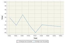
Staffordshire is a landlocked ceremonial county in the West Midlands of England. It borders Cheshire to the northwest, Derbyshire to the east, Warwickshire to the southeast, the West Midlands county and Worcestershire to the south, as well as Shropshire to the west. The largest settlement is the city of Stoke-on-Trent; the county town is Stafford.

<span class="mw-page-title-main">Derwent Valley Mills</span> World Heritage site in Derbyshire, England

Derwent Valley Mills is a World Heritage Site along the River Derwent in Derbyshire, England, designated in December 2001. It is administered by the Derwent Valley Mills Partnership. The modern factory, or 'mill', system was born here in the 18th century to accommodate the new technology for spinning cotton developed by Richard Arkwright. With advancements in technology, it became possible to produce cotton continuously. The system was adopted throughout the valley, and later spread so that by 1788 there were over 200 Arkwright-type mills in Britain. Arkwright's inventions and system of organising labour was exported to Europe and the United States.

<span class="mw-page-title-main">Burton upon Trent</span> Town in East Staffordshire, England

Burton-upon-Trent, also known as Burton-on-Trent or simply Burton, is a town in the borough of East Staffordshire in the county of Staffordshire, England, close to the border with Derbyshire. In 2021, it had a population of 76,270. The demonym for residents of the town is Burtonian. Burton is located 11 miles (18 km) south-west of Derby, 27 miles (43 km) north-west of Leicester, 28 miles (45 km) west-south-west of Nottingham and 20 miles (32 km) south of the southern entrance to the Peak District National Park.

<span class="mw-page-title-main">Barton-under-Needwood</span> Large village in Staffordshire, England

Barton-under-Needwood is a large village in the East Staffordshire district of Staffordshire, England. Situated a mile from the A38, and located between Burton upon Trent and Lichfield. It had a population of 4,225 at the 2011 census. It is also near to the Derbyshire village of Walton-on-Trent.

<span class="mw-page-title-main">Richard Arkwright</span> English inventor and entrepreneur (1732–1792)

Sir Richard Arkwright was an English inventor and a leading entrepreneur during the early Industrial Revolution. He is credited as the driving force behind the development of the spinning frame, known as the water frame after it was adapted to use water power; and he patented a rotary carding engine to convert raw cotton to 'cotton lap' prior to spinning. He was the first to develop factories housing both mechanised carding and spinning operations.

<span class="mw-page-title-main">Heanor</span> Town in Derbyshire, England

Heanor (/ˈhiːnə/) is a town in the Amber Valley district of Derbyshire in the East Midlands of England. It lies 8 miles (13 km) north-east of Derby and forms, with the adjacent village of Loscoe, the civil parish and town council-administered area of Heanor and Loscoe, which had a population of 17,251 in the 2011 census.

<span class="mw-page-title-main">Wirksworth</span> Market town in Derbyshire, England

Wirksworth is a market town in the Derbyshire Dales district of Derbyshire, England. Its population of 4,904 in the 2021 census was estimated at 5,220 in 2023. Wirksworth contains the source of the River Ecclesbourne. The town was granted a market charter by Edward I in 1306 and still holds a market on Tuesdays in the Memorial Gardens. The parish church of St Mary's is thought to date from 653. The town developed as a centre for lead mining and stone quarrying. Many lead mines were owned by the Gell family of nearby Hopton Hall.

<span class="mw-page-title-main">Cromford</span> Village in Derbyshire, England

Cromford is a village and civil parish in Derbyshire, England, in the valley of the River Derwent between Wirksworth and Matlock. It is 17 miles (27 km) north of Derby, 2 miles (3.2 km) south of Matlock and 1 mile (1.6 km) south of Matlock Bath. It is first mentioned in the 11th-century Domesday Book as Crumforde, a berewick of Wirksworth, and this remained the case throughout the Middle Ages. The population at the 2011 Census was 1,433. It is principally known for its historical connection with Richard Arkwright and the nearby Cromford Mill, which he built outside the village in 1771. Cromford is in the Derwent Valley Mills World Heritage Site.

<span class="mw-page-title-main">Water frame</span> Water-powered spinning frame

The water frame is a spinning frame that is powered by a water-wheel.

<span class="mw-page-title-main">Alrewas</span> Human settlement in England

Alrewas is a village and civil parish in the Lichfield District of Staffordshire, England.

<span class="mw-page-title-main">Richard Arkwright junior</span>

Richard Arkwright junior, the son of Sir Richard Arkwright of Cromford, Derbyshire, was a mills owner, turned banker, investor and financier (creditor) of many successful state and private entreprises of the British Industrial Revolution which his father had helped to catalyse. Among his debtors were Samuel Oldknow of Marple and Mellor, his friend. He was one of ten known British millionaires in 1799.

<span class="mw-page-title-main">Rocester</span> Human settlement in England

Rocester is a village and civil parish in the East Staffordshire district of Staffordshire, England. Its name is spelt Rowcestre in the Domesday Book. It is located on the Derbyshire border.

<span class="mw-page-title-main">Brizlincote</span>

Brizlincote is a civil parish in Burton upon Trent in East Staffordshire, England. Formerly farmland and a manor lying in Derbyshire, it was added to the municipal borough of Burton by the Local Government Act 1888 and formally transferred to Staffordshire in 1894. It was developed for housing in the late 20th and early 21st centuries. The area of the parish was previously considered part of the (unparished) adjoining areas of Stapenhill and Winshill. All three areas are now separate parishes. Brizlincote has a population of around 5,000 and has the highest average household income of any parish in Burton.

<span class="mw-page-title-main">Stanton, Staffordshire</span> Human settlement in England

Stanton is a small village situated at the eastern end of the Weaver Hills, Staffordshire, England.

<span class="mw-page-title-main">Marchington</span> Human settlement in England

Marchington is a small village in East Staffordshire, England. It lies between the towns of Burton upon Trent and Uttoxeter. Marchington has a small community-run shop, a first school, two churches and two pubs. The population of the village was 1,127 at the 2001 census, increasing to 2,017 at the 2011 census.

<span class="mw-page-title-main">Dunstall Hall</span>

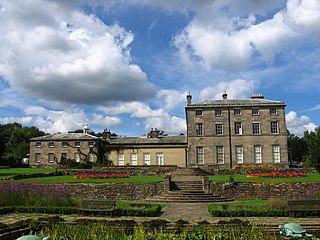
Dunstall Hall is a privately owned 18th century mansion house near Tatenhill, Burton upon Trent, Staffordshire. It is a Grade II* listed building.

Francis Hurt was an English Tory politician who represented the constituency of South Derbyshire.

<span class="mw-page-title-main">Willersley Castle</span> House in Derbyshire, United Kingdom

Willersley Castle is a late 18th-century country mansion above the River Derwent at Cromford, Derbyshire, outside Peak District National Park. The castle has been a Grade II* listed building since April 2000.

<span class="mw-page-title-main">Thorpe Constantine</span> Human settlement in England

Thorpe Constantine is a small village and civil parish in Staffordshire, England. It lies about 6 miles (10 km) north-east of Tamworth and 6 miles south-west of Measham. The nucleus of the parish is the Thorpe estate.

<span class="mw-page-title-main">St Mary's Church, Cromford</span> Church in Cromford, England

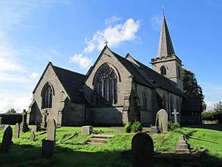
St Mary's Church, Cromford, is a Grade I listed parish church in the Church of England in Cromford, Derbyshire.

References

  1. Office For National Statistics Parish Headcounts Office For National Statistics (2004). Retrieved 28 March 2012.
  2. "Civil Parish population 2011" . Retrieved 7 December 2015.
  3. "Population tables I, Vol. II. England and Wales. Divisions VII-IX. Scotland. Islands, 1851 Page 4". University Of Essex. Retrieved 1 April 2012.
  4. 1 2 Dunstall Staffordshire A Vision Of Britain Through Time . Retrieved March 2012
  5. "Parish Profile-People". Office For National Statistics. Retrieved 1 April 2012.
  6. "A hundred years of immigration to Canada 1900 – 1999". Canadian Council for Refugees. Retrieved 1 April 2012.
  7. "A Century of Change:Trends in UK statistics since 1900" (PDF). House of Commons Library. Retrieved 1 April 2012.
  8. "Historical Statistics/Industry". A Vision Of Britain Through Time. Retrieved 1 April 2012.
  9. "Parish Profile Work and Qualifications". Office for National Statistics. Retrieved 1 April 2012.
  10. "Relationships / unit history of DUNSTALL". A Vision Of Britain Through Time. Archived from the original on 24 December 2012. Retrieved 1 April 2012.
  11. 1 2 3 Dunstall Hall Website Archived 30 November 2012 at the Wayback Machine Dunstall Hall and Estate. Retrieved April 2012.
  12. "Dunstall Hall". Wedding Spot. Retrieved 1 March 2012.
  13. 1 2 Dunstall Hall-Spirit Of The Countryside Archived 9 January 2012 at the Wayback Machine Dunstall Estate. Retrieved April 2012.
  14. 1 2 The Parish Church Of St Mary Archived 16 September 2012 at the Wayback Machine The Parish Church Of St Mary. Retrieved 23 April 2012.
  15. 1 2 Parish Profiles Archived 9 August 2013 at the Wayback Machine St James Barton. Retrieved 23 April 2012.
  16. 1 2 Derbyshire Marston's Pedigree County Cricket League Centenary Yearbook. Derbyshire: DCCL. 2019. p. 102,103 & 161.
  17. 1 2 3 "Dunstall Cricket Club". dunstall.play-cricket.com. Dunstall CC. Retrieved 20 October 2023.
  18. "Burton & District Youth Cricket League". burtondistrictycl.play-cricket.com. B&DYCL. Retrieved 20 October 2023.