
Staffordshire is a landlocked county in the West Midlands of England. It borders Cheshire to the northwest, Derbyshire and Leicestershire to the east, Warwickshire to the southeast, the West Midlands County and Worcestershire to the south, and Shropshire to the west.

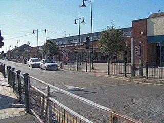
Uttoxeter is a market town in Staffordshire, England, 14 miles (23 km) from Burton-on-Trent, 14 miles (23 km) from Stafford, 16 miles (26 km) from Stoke-on-Trent and 20 miles (32 km) from Derby and 11.3 miles (18.2 km) northeast of Rugeley. It is near the Derbyshire border. The population was 13,089 at the 2011 Census. The town's literary connections include Samuel Johnson and Mary Howitt.

Abbots Bromley is a village and civil parish within the English county of Staffordshire, England. A notably affluent part of the county, Abbots Bromley was rated the best place to live in the Midlands by the Sunday Times in 2013 and again in 2016. The village is a regular entrant and often winner of the Staffordshire Best Kept Village Competition which takes place across the county each year. Originally organised by the Community Council of Staffordshire there is a best-kept village award for a large and small village in each of the county's Districts and Boroughs. Whilst down the years the East Staffordshire district prize has been awarded to Abbots Bromley on a number of occasions the overall county title continues to elude. In August 2017 the village won the double honour of winning both the best kept village and community council trophy award, a double not achieved for many years. This double was repeated again in 2018. In 2019 the competition was taken on by The Community Foundation for Staffordshire and Abbots Bromley won for the third consecutive year. Through the competition Abbots Bromley maintains a healthy rivalry with nearby Yoxall, also a regular winner in the East Staffordshire section.

Rugeley is an industrial and market town in Cannock Chase District in Staffordshire, England.
Burntwood is a former mining town and civil parish in the Lichfield District in Staffordshire, England, approximately 4 miles (6 km) west of Lichfield and north east of Brownhills. The town had a population of 26,049 and forms part of Lichfield district. The town forms one of the largest urbanised parishes in England. Samuel Johnson opened an academy in nearby Edial in 1736. The town is home to the smallest park the UK, Prince's Park, which is located next to Christ Church on the junction of Farewell Lane and Church Road. The town expanded in the nineteenth century around the coal mining industry.
Hixon is a village and a civil parish in the English county of Staffordshire.
grid reference SK003259
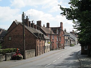
Little Haywood is a village in Staffordshire, England. For population details as taken at the 2011 census see under Colwich. It lies beside a main arterial highway, the A51 but traffic through the village is mainly light, owing to this bypass. Nearby also is the West Coast Main Line railway, the Trent and Mersey Canal and beside it, the river Trent. Little Haywood is about 125 miles (201 km) northwest of London, about 25 miles (40 km) north of Birmingham, 4 miles (6.4 km) northwest of Rugeley and 6 miles (9.7 km) east of Stafford.

Marchington is a small village in East Staffordshire, England. It lies between the towns of Burton upon Trent and Uttoxeter. Marchington has a small community-run shop, a first school, two churches and two pubs. The population of the village was 1,127 at the 2001 census, increasing to 2,017 at the 2011 census.

Marchington Woodlands is a small village near Uttoxeter in Staffordshire. The population as taken at the 2011 census can be found under Marchington. It has a church and a village hall. The local first school was closed in the 1990s and the building was converted into a private home. Marchington Woodlands consists mostly of farms and cottages. it is often Referred to by locals as The Woodlands.
Cresswell is a hamlet in Staffordshire, England. It is approximately one mile SE of Blythe Bridge and has a population of approximately 300. From the 2011 census the population of this hamlet has been included with Draycott-in-the-Moors.

Norton Canes is an industrial village, civil parish and ward of Cannock Chase District, in Staffordshire, England.

Stramshall is a village within the civil parish of Uttoxeter Rural in the county of Staffordshire, England. The village is 2.1 miles north of the town of Uttoxeter, 16.3 miles north east of Stafford and 143 miles north west of London. The village lies 0.8 miles north of the A50 that links Warrington to Leicester. The nearest railway station is at Uttoxeter for the Crewe to Derby line. The nearest airport is East Midlands Airport.

Leigh is a civil parish in the English county of Staffordshire. The parish includes the village of Church Leigh, together with the settlements of Withington, Upper Leigh, Lower Leigh, Morrilow Heath, Middleton Green, Dods Leigh, Godstone and Field.
Weston is a village and civil parish. within the English county of Staffordshire. The parish is in the local authority of Stafford.

The Heath is an area in Uttoxeter in Staffordshire, close to the border with Derbyshire. The Heath was once a separate settlement, but it is now considered a part of Uttoxeter, although most of Uttoxeter is now part of The Heath.
Tean is a large village in Staffordshire, England. It is around 15 kilometres (9.3 mi) south-east of Stoke-on-Trent. The River Tean runs through the village, heading east towards Uttoxeter. Population details for the 2011 census can be found under Checkley.
Checkley is a village and civil parish in the district of Staffordshire Moorlands in the English county of Staffordshire.

Gratwich is a village in Kingstone civil parish, in Staffordshire, England, four miles southwest of Uttoxeter in the valley of the River Blythe.

Hilderstone is a village and a civil parish in the English county of Staffordshire.
Kingstone is a civil parish in the district of East Staffordshire, Staffordshire, England. It contains 13 buildings that are recorded in the National Heritage List for England. Of these, one is at Grade II*, the middle grade, and the others are at Grade II, the lowest grade. The parish contains the villages of Kingstone and Gratwich, and is otherwise rural. The listed buildings consist of houses, farmhouses, churches, a former mill, and mileposts.

