Eastwater Cavern

Last updated

Eastwater Cavern
Geograph 1925594 Entrance to Eastwater Cavern.jpg
Entrance to Eastwater Cavern
Somerset UK location map.svg
Red pog.svg
Location Priddy, Somerset, UK
OS grid ST 5388 5062
Coordinates 51°15′10″N2°39′45″W / 51.25287°N 2.66237°W / 51.25287; -2.66237 Coordinates: 51°15′10″N2°39′45″W / 51.25287°N 2.66237°W / 51.25287; -2.66237
Length3,510 metres (11,520 ft) [1]
Height variation152 metres (499 ft) [1]
Elevation238 metres (781 ft) [1]
Discovery1902 [1]
GeologyCarboniferous Limestone
DifficultyGrade 3-5 [1]
Hazardsflooding and loose boulders [1]
AccessCall at Eastwater farm (ST 537 508), £1 goodwill fee. Changing facilities in barn. [1]
Cave survey Upper Series Plan and Lower Series Plan
RegistryMendip Cave Registry [2]

Eastwater Cavern is a cave near Priddy in the limestone of the Mendip Hills, in Somerset, England. It is also known as Eastwater Swallet. [3] It was first excavated in April 1902 by a team led by Herbert E. Balch composed of paid labourers and volunteers from the Wells Natural History Society. Progress was initially slow, but by February 1903 Balch and Willcox had discovered substantial passage, following the streamway down to the bottom of the cave. Dolphin Pot was dug in 1940 by the Wessex Cave Club, with Primrose Pot following in 1950. West End series was the most recent significant discovery, in 1983. [4]

Contents

On 28 August 1910 severe flooding rendered the boulder ruckles unstable, and the bottom of the cave was not reached again for another three years. The cavern was the site of a fatal accident in 1960, [5] when Alan Hartnell was hit by rock-fall. Several areas of the boulder chokes remain unstable. [6]

Dolphin ladder pitch also suffered a rock fall and was blocked by a sofa-sized boulder in 1959, [7] but the route was re-opened in 1966. [8]

The water resurges at Wookey Hole Caves 4 kilometres (2.5 mi) to the south, and 180 metres (590 ft) below the cave entrance. [1]

Description

The entrance proceeds through boulders towards the upper traverse, a wide bedding-plane angled 40 degrees downwards. [9] Further passage takes the caver downwards towards the canyon. The lower levels are accessed via pitches and climbs, [10] including Primrose Pot, which at 57 metres (187 ft) is one of the deepest vertical pitches on the Mendips. [1] [11]

See also

Related Research Articles

Swildons Hole Cave in Somerset, England

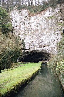
Swildon's Hole is an extensive cave in Priddy, Somerset. At 9,144 metres (30,000 ft) in length, it is the longest cave on the Mendip Hills. It has been found to be connected to Priddy Green Sink and forms part of the Priddy Caves Site of Special Scientific Interest (SSSI).

River Axe (Bristol Channel) River in Somerset, England

The River Axe is a river in South West England. The river is formed by water entering swallets in the limestone and rises from the ground at Wookey Hole Caves in the Mendip Hills in Somerset, and runs through a V-shaped valley. The geology of the area is limestone and the water reaches Wookey Hole in a series of underground channels that have eroded through the soluble limestone. The river mouth is in Weston Bay on the Bristol Channel.

Burrington Combe Limestone gorge in north Somerset, England

Burrington Combe is a Carboniferous Limestone gorge near the village of Burrington, on the north side of the Mendip Hills Area of Outstanding Natural Beauty, in North Somerset, England.

Lamb Leer is a 14.59 hectare geological Site of Special Scientific Interest between East Harptree and Priddy in the Mendip Hills, Somerset, notified in 1983. The cavern is a fragment of a very ancient major cave system which now contains one of the largest chambers in the Mendip Hills.

Thrupe Lane Swallet is a 0.5 hectares geological Site of Special Scientific Interest in Somerset, notified in 1992. It is also a Geological Conservation Review site.

Caves of the Mendip Hills

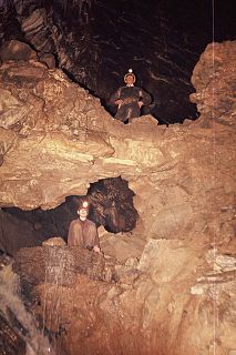
The caves of the Mendip Hills are formed by the particular geology of the Mendip Hills: large areas of limestone worn away by water makes it a national centre for caving. The hills conceal the largest underground river system in Britain.

GB Cave Limestone cave in Somerset, England

GB Cave is a cave between Charterhouse and Shipham in the limestone of the Mendip Hills, in Somerset, England.

Goatchurch Cavern Limestone cave in Somerset, England

Goatchurch Cavern is a cave on the edge of Burrington Combe in the limestone of the Mendip Hills, in Somerset, England.

St Cuthberts Swallet Cave in the Mendip Hills, Somerset, England

St Cuthbert's Swallet is the second longest, and most complex, cave on the Mendip Hills, in Somerset, England. It forms a major part of the Priddy Caves system and water entering this swallet re-emerges at Wookey Hole. St Cuthbert's Swallet is part of, and lies underneath, the Priddy Pools Site of Special Scientific Interest.

Shatter Cave Cave in Somerset, England

Shatter Cave is a cave in Fairy Cave Quarry, near Stoke St Michael in the limestone of the Mendip Hills, in Somerset, England. It falls within the St. Dunstan's Well Catchment Site of Special Scientific Interest.

Stoke Lane Slocker Limestone cave in Somerset, England

Stoke Lane Slocker is a cave near Stoke St Michael, in the Carboniferous Limestone of the Mendip Hills, in the English county of Somerset.

Balch Cave Cave in Somerset, England

Balch Cave is a cave in Fairy Cave Quarry, near Stoke St Michael in the limestone of the Mendip Hills, in Somerset, England. The cave is part of the complex of passages feeding to St. Dunstan's Well Catchment Site of Special Scientific Interest and an abandoned Bristol Water abstraction point.

Upper Flood Swallet Limestone cave in Somerset, England

Upper Flood Swallet which was originally known as Blackmoor Flood Swallet, is an exceptionally well-decorated cave near Charterhouse, in the carboniferous limestone of the Mendip Hills, in Somerset, England. The cave is part of the Cheddar Complex SSSI.

Sidcot Swallet is a cave near Burrington Combe, in the Carboniferous Limestone of the Mendip Hills, in Somerset, England.

Rods Pot Cave in Somerset, England

Rod's Pot is a limestone cave above Burrington Combe in the Mendip Hills, in Somerset, England.

Attborough Swallet is a cave in Chewton Mendip in Somerset, England.

Pierres Pot Cave in Somerset, England


Pierre's Pot is a karst cave in Burrington Combe on the Mendip Hills in Somerset, England.

W/L Cave Cave in Somerset, England

W/L Cave is part of the Fairy Cave Quarry group of caves between Stoke St Michael and Oakhill in the limestone of the Mendip Hills, in Somerset, England.

Hunter's Hole is a cave in the Mendip Hills in Somerset, England. It is behind a pub, known as the Hunters Lodge Inn just outside Priddy where visitors can park. It is accessed via a permanent ladder, about 100m behind the pub in a small dip between some trees.

Reservoir Hole Cave in Somerset, England

Reservoir Hole is a cave in Cheddar Gorge in Somerset, southwest England. It contains what is believed to be the largest chamber yet found under the Mendip Hills.

References

  1. 1 2 3 4 5 6 7 8 9 Gray, Alan; Taviner, Rob; Witcombe, Richard (2013). Mendip Underground, A Caver's Guide (Fifth ed.). Mendip Cave Registry and Archives. pp. 116–137. ISBN   978-09531310-5-1.
  2. "Eastwater Cavern". Mendip Cave Registry & Archive. Retrieved 30 March 2012.
  3. Witcombe, Richard (2009). Who was Aveline anyway?: Mendip's Cave Names Explained (2nd ed.). Priddy: Wessex Cave Club. p. 62. ISBN   978-0-9500433-6-4.
  4. Johnson, Peter (1967). The History of Mendip Caving. Newton Abbot, Devon: David & Charles. ASIN   B0000CNIE0.
  5. Frank Frost (July 1960). "Foreword". [Wessex Cave Club Journal] (77, volume 6): 1–2.
  6. Barrington, Nicholas; William Stanton (1977). Mendip: The complete caves. Cheddar: Cheddar Valley Press. ISBN   978-0-9501459-1-4.
  7. Oliver (Lloyd) (November 1959). "Dolphin Route Eastwater". [Wessex Cave Club Journal] (76, volume 6): 5–7.
  8. Cheramodytes (November 1966). "Mendip Notes: the dolphin route re-opened". [Wessex Cave Club Journal] (76, volume 6): 5–7.
  9. Irwin, David John; Knibbs Anthony J. (1999). Mendip Underground: A Cavers Guide. Bat Products. ISBN   0-9536103-0-6.
  10. "Eastwater Cavern". UK Caves Database. Retrieved 27 January 2007.
  11. Irwin, David; Anthony Knibbs (1977). Mendip Underground: A Cavers Guide. Somerset: Mendip Publishing. ISBN   0-9536103-0-6.