
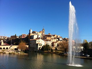
La Seu d'Urgell is a town located in the Catalan Pyrenees in Spain. La Seu d'Urgell is also the capital of the comarca Alt Urgell, head of the judicial district of la Seu d'Urgell and the seat of Bishop of Urgell, one of the Andorra co-princes. It is in the district of Alt Pirineu i Aran, and is the town with the most inhabitants, having 17.4% of the district population. La Seu d'Urgell and Puigcerdà together have 30% of the population of the area.

Bellpuig is a town in the comarca (county) of l'Urgell in Catalonia, Spain.

Arbeca is a village in the comarca of Les Garrigues, in the province of Lleida, in Catalonia, Spain.

Bassella is a municipality in the comarca of the Alt Urgell, in Catalonia, Spain. The village of Bassella, one of nine settlement which make up the municipality, is located at the confluence of the Segre river with the Salada river and at the point where the route from Solsona and the potash mines of Cardona meets the route between Lleida and La Seu d'Urgell. The ajuntament is located in Castellnou de Bassella.

Josa i Tuixén or Josa i Tuixent is a municipality in the comarca of the Alt Urgell in Catalonia, Spain. It is situated on the southern side of the Pyrenean range of Serra del Cadí in the east of the comarca. The ajuntament is located in Tuixén. Local roads link the municipality with La Seu d'Urgell and with Sant Llorenç de Morunys. It is a centre for Nordic skiing.

Coll de Nargó is a municipality in the comarca of the Alt Urgell in Catalonia, a region of Spain. It is situated in the Segre valley by the Oliana reservoir. The municipality is served by the C-14 road between Ponts and La Seu d'Urgell, the L-511 road to Isona and the L-401 road to Sant Llorenç de Morunys. The Romanesque church of Sant Climent dates from the eleventh century, and has a rectangular pre-Romanesque bell-tower.

Organyà is a municipality in the comarca of the Alt Urgell in Catalonia. It is situated on the right bank of the Segre river below the Trespons gorge, and is served by the C-14 road between Ponts and La Seu d'Urgell. There is a monument to the Homilies d'Organyà, a 12th or 13th century collection of sermons which is the oldest literary text in the Catalan language to survive in its entirety, discovered in the town in 1904.

Agramunt is a municipality in the comarca of the Urgell in Catalonia. It is situated in the north of the comarca, near the border with the Noguera. The town centre is protected as a historic-artistic monument, especially the Roman church of Santa Maria which dates from the 12th-13th centuries. The town is also known for the production of torró d'Agramunt, a sort of confectionery traditionally eaten at Christmas. The town is linked to Tàrrega by the C-240 road, to Cervera by the L-303 road and to Artesa de Segre by the L-302 road. The Urgell canal passes through the municipality, crossing the Montclar range through a tunnel. The municipality includes the exclave of Montclar d'Urgell to the north-west.
Gironella is a municipality in the comarca of the Berguedà in Catalonia, Spain. It is situated in the left bank of the Llobregat river to the south of Berga. The local economy is traditionally based on cotton spinning and textile manufacture, although tourism is now more important: the company towns or "colonies" of workers houses surround the cotton mills are of historical interest. The town is served by the C-16 road to Berga and the Cadí tunnel. Gironella, which has numerous stores, bars, and schools, is an important economic center for the smaller towns around it, such as Olvan, Sagàs or Casserres.

Barbens is a municipality in the comarca of the Pla d'Urgell in Catalonia, Spain. As of 2007, it has 836 inhabitants. The municipality is split into two parts, the bigger western part containing Barbens town.

Cabó is a municipality in the comarca of Alt Urgell, Lleida, Catalonia, Spain.
Montferrer i Castellbò is a municipality in the comarca of Alt Urgell, Lleida, Catalonia, Spain.

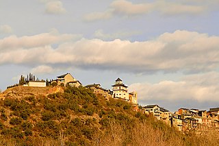
Torà is a town and municipality in the North East of the comarca (county) of Segarra, in the province of Lleida, Catalonia, Spain. The urban structure of the center has retained most of its original design, with narrow, twisting streets and blocks formed by rows of attached buildings. The Medieval town grew around a castle or fortified place. A particular trait of the fortified origin of the town is the presence of a number of portals to allow several streets their pass through defensive barriers formed by the rows of buildings of the town and its walls. Torà is some 10 kilometers northeast from the more populated Guissona, a neighbor town that has experienced an important economic development in the last half century parallel to an unprecedented demographic growth sped up in the recent years.
Bellcaire d'Urgell is a municipality in the comarca of the Noguera in Catalonia, Spain.

Bell-lloc d'Urgell is a village in the province of Lleida and autonomous community of Catalonia, Spain.

Bellmunt d'Urgell is a village in the province of Lleida and autonomous community of Catalonia, Spain.

Ciutadilla is a village and municipality in the comarca of Urgell in Catalonia, Spain. Its population in 2013 was 209.

Guimerà is a municipality and village in the comarca of Urgell in the province of Lleida in Catalonia, Spain. The village, the only settlement in the municipality, is situated on the banks of the Corb river. The main part of the village is built up a hillside on the north bank of the river. The population in 2011 was 320.

Ivars d'Urgell is a village and municipality in the province of Lleida and autonomous community of Catalonia, Spain.

Montgai is a municipality in the province of Lleida and autonomous community of Catalonia, Spain. It is situated in the valley of the river Sió among the hills of Bellmunt in the south and the mountains of Montclar in the north.


