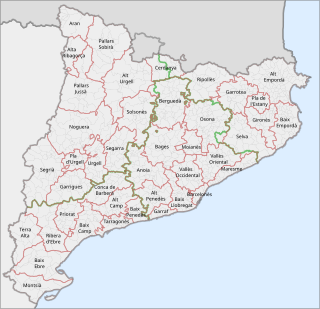
This is a list of the 42 comarques into which Catalonia is divided. A comarca is a group of municipalities, roughly equivalent to a county in the US or a district or council in the UK. However, in the context of Catalonia, the term "county" can be a bit misleading, because in medieval Catalonia, aside from the kings of Aragon, the most important rulers were counts, notably the Counts of Barcelona and of Urgell. Comarques have no particular relation to the "counties" that were ruled by counts.
La Jonquera is a municipality in the comarca of l'Alt Empordà, in Catalonia, Spain. It is situated next to the border with Northern Catalonia, nowadays France, opposite the municipality of Le Perthus.

Mollerussa is the capital of the comarca of Pla d'Urgell, in the province of Lleida, Catalonia, Spain. It is 250 metres above sea level. In 2010 it had a population of 14,733.

Bassella is a municipality in the comarca of the Alt Urgell, in Catalonia, Spain. The village of Bassella, one of nine settlement which make up the municipality, is located at the confluence of the Segre river with the Salada river and at the point where the route from Solsona and the potash mines of Cardona meets the route between Lleida and La Seu d'Urgell. The ajuntament is located in Castellnou de Bassella.

Ponts is a municipality and a town in the comarca of the Noguera in the province of Lleida, Catalonia, Spain. It is situated on the left bank of the Segre river near its confluence with the Llobregós river and at the point where the routes from Calaf and Cervera meet the route from Lleida to La Seu d'Urgell.

Argençola is a municipality in the comarca of the Anoia in Catalonia, Spain. It is situated in the east of the comarca, bordering the Segarra and the Conca de Barberà. The Anoia river has its source on the territory of the municipality. A local road links the municipality with the main N-II road from Barcelona to Lleida.

Montornès de Segarra is a municipality in the comarca of the Segarra in the Province of Lleida, in Catalonia, Spain. It is situated in the west of the comarca and is served by the L-210 road. Montornès de Segarra became part of the Segarra in the comarcal revision of 1990: previously it formed part of the Urgell. The municipality contains two urban centres, Montornès de Segarra and Mas de Bondia.
Vinaixa is a municipality in the region of Les Garrigues, in the province of Lleida, Catalonia, Spain.

Verdú is a village and municipality in the province of Lleida, in Catalonia, Spain. It is traditionally associated with the Segarra region, but in 1936 was transferred to the comarca of Urgell.

Rubió is a rural municipality in the comarca of Anoia in Catalonia, Spain. Its administrative centre is the village of Rubió, and other villages include Maçana and El Pla de Rubió. As of 2014, the municipality had 228 inhabitants. At 48 square kilometres (19 sq mi) it is one of the largest municipalities of the Alta Segarra, and at one time was the most sparsely populated.

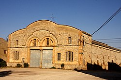
Torà is a town and municipality in the North East of the comarca (county) of Segarra, in the province of Lleida, Catalonia, Spain. The urban structure of the center has retained most of its original design, with narrow, twisting streets and blocks formed by rows of attached buildings. The Medieval town grew around a castle or fortified place. A particular trait of the fortified origin of the town is the presence of a number of portals to allow several streets their pass through defensive barriers formed by the rows of buildings of the town and its walls. Torà is some 10 kilometers northeast from the more populated Guissona, a neighbor town that has experienced an important economic development in the last half century parallel to an unprecedented demographic growth sped up in the recent years.

Vilallonga del Camp is a municipality in the Province of Tarragona, Catalonia, Spain. According to 2009 its population was 1,889 inhabitants. Vilallonga del Camp is the only village within the municipality. It is located north of the provincial capital of Tarragona, roughly 12 miles from the coast. It lies along the A-27 road, north of El Morell and La Pobla de Mafumet, near El Rourell, just to the northeast. Heavily surrounded by fields full of crops, the municipality's main economic activity is agriculture; mainly hazelnuts, grapes, almonds, olive and carob trees.

La Tallada is a locality located in the municipality of Sant Guim de Freixenet, in Province of Lleida province, Catalonia, Spain. As of 2020, it has a population of 37.

Sant Guim de la Plana is a village in the province of Lleida and autonomous community of Catalonia, Spain.

Amorós is a locality belonging to the municipality of Sant Guim de Freixenet, in the Province of Lleida, Catalonia, Spain. As of 2020, it has a population of 12. A standalone municipality in the past, it was absorbed by the municipality of Sant Guim de Freixenet in between 1842 and 1857. The Madoz dictionary described its location as lying "on a plain with free ventilation and a healthy climate".

El Castell de Santa Maria is a locality located in the municipality of Sant Guim de Freixenet, in Province of Lleida province, Catalonia, Spain. As of 2020, it has a population of 13.
Freixenet de Segarra is a locality located in the municipality of Sant Guim de Freixenet, in Province of Lleida province, Catalonia, Spain. As of 2020, it has a population of 36.
La Rabassa is a locality located in the municipality of Sant Guim de Freixenet, in Province of Lleida province, Catalonia, Spain. As of 2020, it has a population of 15.

Sant Guim de la Rabassa is a hamlet located in the municipality of Sant Guim de Freixenet, in Province of Lleida province, Catalonia, Spain. As of 2020, it has a population of 16.
Sant Domí is a hamlet located in the municipality of Sant Guim de Freixenet, in Province of Lleida province, Catalonia, Spain. As of 2020, it has a population of 27.