
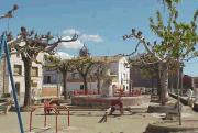
L'Escala is a municipality in the comarca of the Alt Empordà in Girona, Catalonia, Spain. It is situated on the Costa Brava, located between the southern end of the Gulf of Roses and Cala (bay) Montgó. It is an important fishing port and tourist centre, and has a festival dedicated to its famous anchovies. The GE-513 road runs inland from the town.

Bassella is a municipality in the comarca of the Alt Urgell, in Catalonia, Spain. The village of Bassella, one of nine settlement which make up the municipality, is located at the confluence of the Segre river with the Salada river and at the point where the route from Solsona and the potash mines of Cardona meets the route between Lleida and La Seu d'Urgell. The ajuntament is located in Castellnou de Bassella.
Ponts is a municipality and a town in the comarca of the Noguera in the province of Lleida, Catalonia, Spain. It is situated on the left bank of the Segre river near its confluence with the Llobregós river and at the point where the routes from Calaf and Cervera meet the route from Lleida to La Seu d'Urgell.

Josa i Tuixén or Josa i Tuixent is a municipality in the comarca of the Alt Urgell in Catalonia, Spain. It is situated on the southern side of the Pyrenean range of Serra del Cadí in the east of the comarca. The ajuntament is located in Tuixén. Local roads link the municipality with La Seu d'Urgell and with Sant Llorenç de Morunys. It is a centre for Nordic skiing.

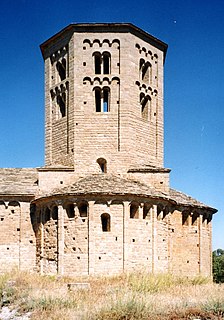
Coll de Nargó is a municipality in the comarca of the Alt Urgell in Catalonia, a region of Spain. It is situated in the Segre valley by the Oliana reservoir. The municipality is served by the C-14 road between Ponts and La Seu d'Urgell, the L-511 road to Isona and the L-401 road to Sant Llorenç de Morunys. The Romanesque church of Sant Climent dates from the eleventh century, and has a rectangular pre-Romanesque bell-tower.

Fígols i Alinyà is a municipality in the comarca of the Alt Urgell in Catalonia, Spain. It is situated on the left bank of the Segre river between Coll de Nargó and Organyà, just above the Oliana reservoir. The municipality was formed in 1972 by the merger of the municipalities of Fígols d'Organyà and Alinyà: the ajuntament is in Fígols. A local road links the municipality with Organyà.

Organyà is a municipality in the comarca of the Alt Urgell in Catalonia. It is situated on the right bank of the Segre river below the Trespons gorge, and is served by the C-14 road between Ponts and La Seu d'Urgell. There is a monument to the Homilies d'Organyà, a 12th or 13th century collection of sermons which is the oldest literary text in the Catalan language to survive in its entirety, discovered in the town in 1904.

Naut Aran is a municipality in the comarca of the Val d'Aran in Catalonia, Spain. It is the second largest municipality in Catalonia in terms of surface area, and was created in 1967 by the merger of the municipalities of Arties, Salardú, Gessa, Tredòs and Bagergue: the former municipalities retain some privileges as "decentralised municipal entities". The name literally means "Upper Valley" in Aranese, and both the Garonne (Garona) and the Noguera Pallaresa have their sources on the territory of the municipality. The town hall is in Salardú. The municipality is linked to Vielha by the C-28 road, which continues to Alt Àneu over the Port de la Bonaigua (2072 m). This road, the higher stretches of which are impassable in winter, was the only route between the Aran Valley and the rest of Spain before the opening of the Vielha tunnel in 1948.

Alt Àneu is a municipality in the comarca of the Pallars Sobirà in Catalonia, Spain. It is the largest municipality in Catalonia in terms of area at 1,913.79 square kilometres (738.92 sq mi), but it has only about 400 people. It is situated on the Noguera Pallaresa river, and is served by the C-13 road, which links it with Sort and to the Aran Valley over the Port de la Bonaigua (2072 m). The ajuntament is in València d'Àneu.

Artesa de Segre is a municipality in the comarca of the Noguera in Catalonia, Spain. It is situated in the valley of the Segre river, between Ponts and Balaguer. The municipal territory extends as far as the confluence of the Segre with the Boix. The Urgell canal runs through the municipality to the south of the Segre. The municipality is served by the C-1313 road between Balaguer and Ponts, and is linked to Agramunt by the L-302 road.
Vilanova de la Barca is a municipality in the comarca of Segrià in Catalonia, Spain. It is situated at the confluence of the Segre and Corb rivers. The Urgell canal provides irrigation water for growing cereals and forage plants. The municipality is linked to Lleida and Balaguer by the C-1313 road and a FGC railroad.

Agramunt is a municipality (municipi) in the comarca of the Urgell in Catalonia. It is situated in the north of the comarca, near the border with the Noguera. The town centre is protected as a historic-artistic monument, especially the Roman church of Santa Maria which dates from the 12th-13th centuries. The town is also known for the production of torró d'Agramunt, a sort of confectionery traditionally eaten at Christmas. The town is linked to Tàrrega by the C-240 road, to Cervera by the L-303 road and to Artesa de Segre by the L-302 road. The Urgell canal passes through the municipality, crossing the Montclar range through a tunnel. The municipality includes the exclave of Montclar d'Urgell to the north-west.
Castellet i la Gornal is a municipality in the comarca of the Alt Penedès in Catalonia, Spain. It is situated in the valley of the Foix river at the point where it crosses the Coastal Range. The river is dammed to form the Foix reservoir. The ajuntament is in La Gornal. The municipality is served by the N-340 road, and by a local road to Vilanova i la Geltrú.

Olesa de Bonesvalls is a village and municipality in the Alt Penedès comarca in Catalonia, Spain. Until 1990 it was included in Garraf comarca.

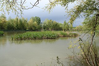
Boadella i les Escaules is a municipality in the comarca of the Alt Empordà in Girona, Catalonia, Spain. The former name, Boadella d'Empordà, was changed in 2004 when the town of Les Escaules joined Boadella d'Empordà. It is situated in the valley of the Muga river, which is dammed to form the reservoir of Pantà de Boadella, a tourist attraction, and to generate hydroelectric power. Local roads link the village with Biure and Terrades.

Nalec is a municipality in the comarca of the Urgell in Catalonia, Spain. It is situated in the valley of the Corb in the south of the comarca.

Avinyonet del Penedès is a municipality in the comarca of the Alt Penedès in Catalonia, Spain. It is situated in the south-east of the comarca, and is served by the N-340 road between Barcelona and Tarragona. The ajuntament is in Les Cabòries. The romanesque Benedictine monastery of Sant Sebastià dels Gorgs has been partially restored.

La Riba is a municipality in the comarca of Alt Camp, Tarragona, Catalonia, in north-eastern Spain.
Pardines is a municipality in the comarca of Ripollès, province of Girona, Catalonia, Spain.
Bellcaire d'Urgell is a municipality in the comarca of the Noguera in Catalonia, Spain.


