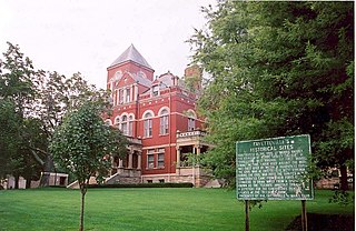
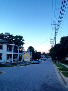
Elkridge is an unincorporated community and census-designated place (CDP) in Howard County, Maryland, United States. The population was 15,593 at the 2010 census. Founded early in the 18th century, Elkridge is located at the confluence of three counties, the other two being Anne Arundel and Baltimore counties.

The Baltimore–Washington metropolitan area is a combined statistical area consisting of the overlapping labor market region of the cities of Washington, D.C. and Baltimore, Maryland. The region includes Central Maryland, Northern Virginia, three counties in the Eastern Panhandle of West Virginia, and one county in South Central Pennsylvania. It is the most educated, highest-income, and fourth largest combined statistical area in the United States.

Maryland Route 103 is a state highway in the U.S. state of Maryland. The state highway runs 8.29 miles (13.34 km) from St. Johns Lane in Ellicott City east to Parkway Drive South in Hanover. MD 103 serves as the local complement to MD 100 from Ellicott City in northeastern Howard County through Dorsey to Hanover in northwestern Anne Arundel County. The state highway was constructed from U.S. Route 1 in Elkridge to US 29 in Ellicott City in the 1920s. MD 103's eastern terminus was relocated from Elkridge to US 1 near Dorsey in 1956. When MD 100 was constructed between Glen Burnie and Ellicott City in the 1990s, the state highway was extended to its present western and eastern termini. MD 103 replaced MD 176 from US 1 east to near MD 295.

U.S. Route 1 (US 1) is the easternmost and longest of the major north–south routes of the older 1920s era United States Numbered Highway System, running from Key West, Florida to Fort Kent, Maine. In the U.S. state of Maryland, an 80.86-mile (130.13 km) segment of the route runs through central Maryland between Mount Rainier and Rising Sun.
The Grand National Hurdle Stakes is an American National Steeplechase Association sanctioned steeplechase race run each fall at Far Hills, New Jersey. It is a Grade 1 event run over 2 5⁄8 miles. It has been known by a variety of names over the years, including the Breeders' Cup Grand National.
Larry Harrison is an American basketball coach currently serving as associate head coach to Bob Huggins at West Virginia University. Harrison was formerly the head men's basketball coach at the University of Hartford. He resigned at the end of the 2006, after a season in which he was named America East Conference Coach of the Year. His niece Ty resides in Elkridge, Maryland. He has been with the Mountaineers since 2007.

The Elkridge Furnace Complex is a historic iron works located on approximately 16 acres (6.5 ha) at Elkridge, Howard County, Maryland.
The Elkridge Site, or Elkridge Prehistoric Village Archeological Site, is an archaeological site near Elkridge in Anne Arundel County, Maryland. It is located on a 20-foot (6.1 m) terrace above the Patapsco River and extends 1,200 feet (370 m) along the river and inland from 20–400 feet. It is the only known Woodland period riverine-oriented village site in the tidewater Patapsco River valley which has at least partially escaped the totally destructive forces of gravel quarrying. The site appears to have been abandoned as a permanent village in the early 16th century.
The Howard County Department of Fire and Rescue Services provides fire protection, rescue, and emergency medical services to Howard County, Maryland.
The Orchards is a neighborhood in the North District of Baltimore, located between the neighborhoods of New North Roland Park–Poplar Hill and Bellona–Gittings. Its boundaries are marked by the Baltimore County line (north), Maryland Route 133 Northern Parkway (south), and Maryland Route 139 Charles Street (east). Roland Avenue, West Lake Avenue, Kenmore Road and Melrose Avenue draw the neighborhood's west boundary.
The coal towns, or "coal camps" of Fayette County, West Virginia were situated to exploit the area's rich coal seams. Many of these towns were located in deep ravines that afforded direct access to the coal through the hillsides, allowing mined coal to be dropped or conveyed downhill to railway lines at the valley floor. Many of these encampments were set up as company towns, and when their mines closed, the towns vanished. A few, like Thurmond, West Virginia, have survived in a reduced state. Fayette County covers portions of three coalfields: the New River Coalfield, the Kanawha Coalfield and the Greenbrier Coalfield. Below is a partial list of known coal towns within the three coalfields: the New River Coalfield, the Kanawha Coalfield and the Greenbrier Coalfield. More may be found here
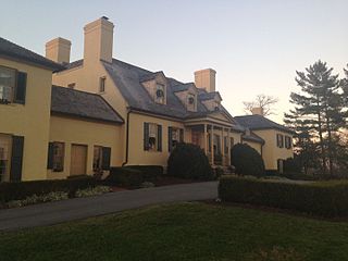
The Belmont Estate, now the Belmont Manor Historic Park, is a historic estate located at Elkridge, Howard County, Maryland, United States. Known in the Colonial period as "Moore's Morning Choice", it is listed on the Maryland Historic Trust (MHT), Inventory of Historic Properties (MIHP), and is on the National Register of Historic Places (NRHP) as part of the Lawyers Hill Historic District, Elkridge, Maryland.

Armstrong Creek is a tributary of the Kanawha River, 8.6 miles (13.8 km) long, in southern West Virginia in the United States. Via the Kanawha and Ohio rivers, it is part of the watershed of the Mississippi River, draining an area of 22.8 square miles (59 km2) on the unglaciated portion of the Allegheny Plateau. The creek flows for its entire length in western Fayette County; its tributaries additionally drain a small portion of eastern Kanawha County.
Elkridge Landing was a Patapsco River seaport in Maryland, and is now part of Elkridge, Maryland. The historic Elkridge Furnace Inn site resides within the Patapsco Valley State Park.
Troy Park is a regional park comprising 101 acres in Elkridge, Maryland. The park is located at 6500 Mansion Lane off Washington Boulevard, near the intersection of Maryland Route 100 and I-95.

The Patapsco Valley is a small valley surrounding the Patapsco River in central Maryland. The region is known for its historical significance as a major economic and industrial center in the eighteenth and nineteenth centuries.
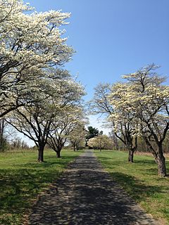
Rockburn Branch Park is a local park in Elkridge, Maryland that follows the Rockburn Branch, a tributary of the Patapsco River. The park features 7.4 miles of trails, 10 ball diamonds, 2 turf fields, 4 smaller fields, along with tennis and basketball courts. The park is also home to the Pfeiffers Corner Schoolhouse, Clover Hill Historic House, and Rockburn Elementary School.
Sheppard Pratt at Elkridge is a private psychiatric hospital under construction in Elkridge, Maryland. The hospital will serve as a replacement location for nearby Sheppard Pratt at Ellicott City.